Item 6: Parking and
Vehicle Control Bylaw (2011), No 207
Amendments to Schedules
|

|
Hearing Panel
24 March 2023
|
REPORT R26504
Parking
and Vehicle Control Bylaw (2011), No 207
Amendments to Schedules
1. Purpose of Report
To approve proposed alterations
to Schedules of the Parking and Vehicle Control Bylaw (2011), No 207, to give
effect to minor safety and parking improvements, roading improvements carried
out as part of the capital works programme and changes from new subdivisions.
2. Recommendation
|
That the Hearing Panel
1. Receives
the report Parking and Vehicle Control Bylaw (2011), No 207 Amendments to
Schedules (R26504) and its
attachments (1355221503-8263 and 1355221503-8016); and
2. Approves amendments detailed
in report R27231 and its attachments (1355221503-8263 and 1355221503-8016) to
the following Schedules of the Bylaw, Parking and Vehicle Control (2011), No
207:
· Schedule
1 – One Way Streets
· Schedule
4 - Special Parking Areas
· Schedule
8 – Time Limited Parking Areas
· Schedule
9 – No Stopping and no Parking Areas
· Schedule
13 – Stop Signs
· Schedule
14 – Give Way Signs
|
3. Background
3.1 The Parking and
Vehicle Control Bylaw 2011 allows for the Council by resolution, to add, amend
or delete specifications contained within the Schedules. The Council has
delegated this power to the Hearings Panel. To ensure that the Bylaw is
enforceable it is important to ensure that the Schedules are updated on a
regular basis. The Bylaw Schedules were last updated in September 2022.
3.2 Minor alterations and
additions are proposed to Schedules 1, 4, 8, 9, 13 and 14 of the Bylaw as
detailed in section 4.
3.3 The proposed
alterations and additions are shown for indicative purposes only by plans
attached to this report. The purpose of these plans is to assist the Panel to
easily and quickly understand the nature of the changes proposed. These plans
will not form part of the final bylaw. The actual changes as they will be
incorporated into the final schedules of the Bylaw, and with the level of detail
required for enforcement purposes, are set out in the schedule of changes
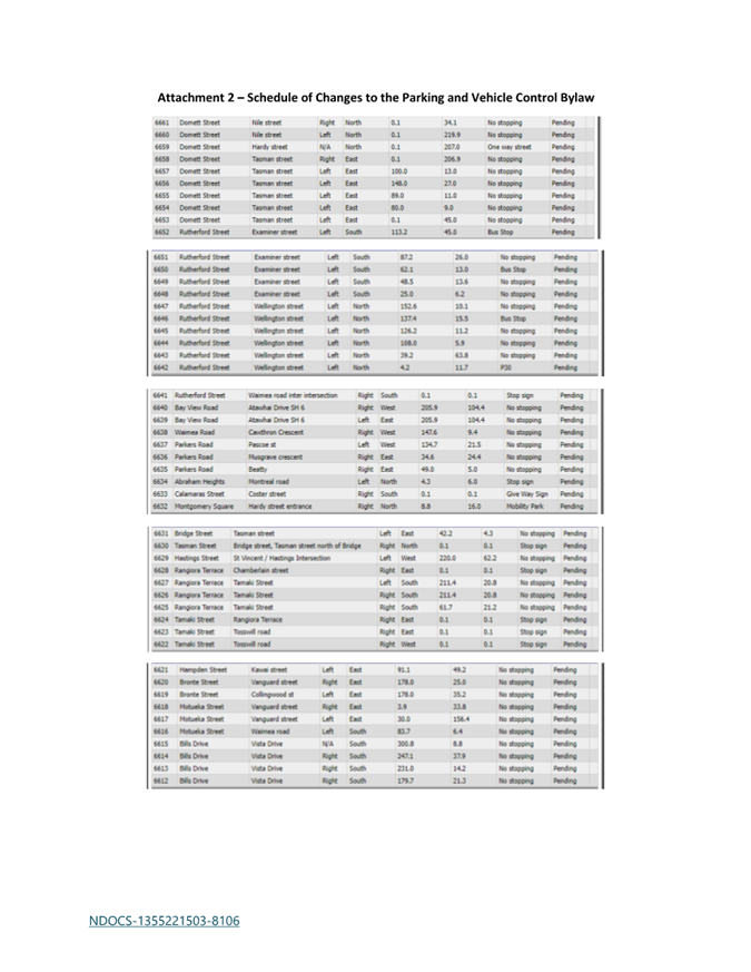
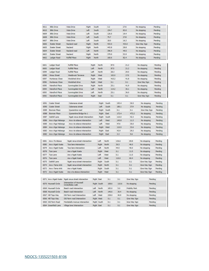
appended as Attachment 2.
4. Discussion
Schedule 1 – One Way
Streets
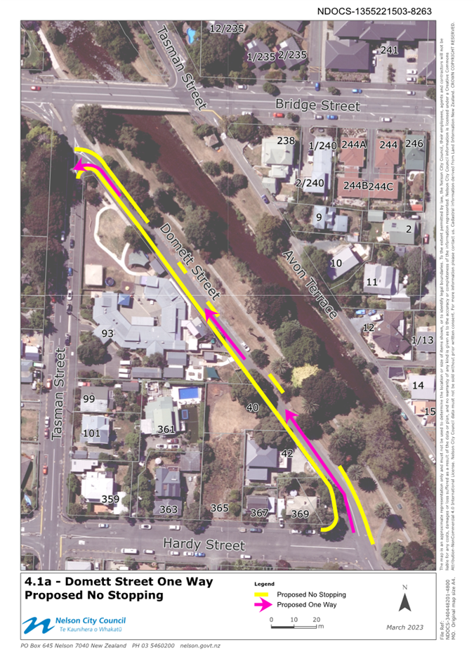
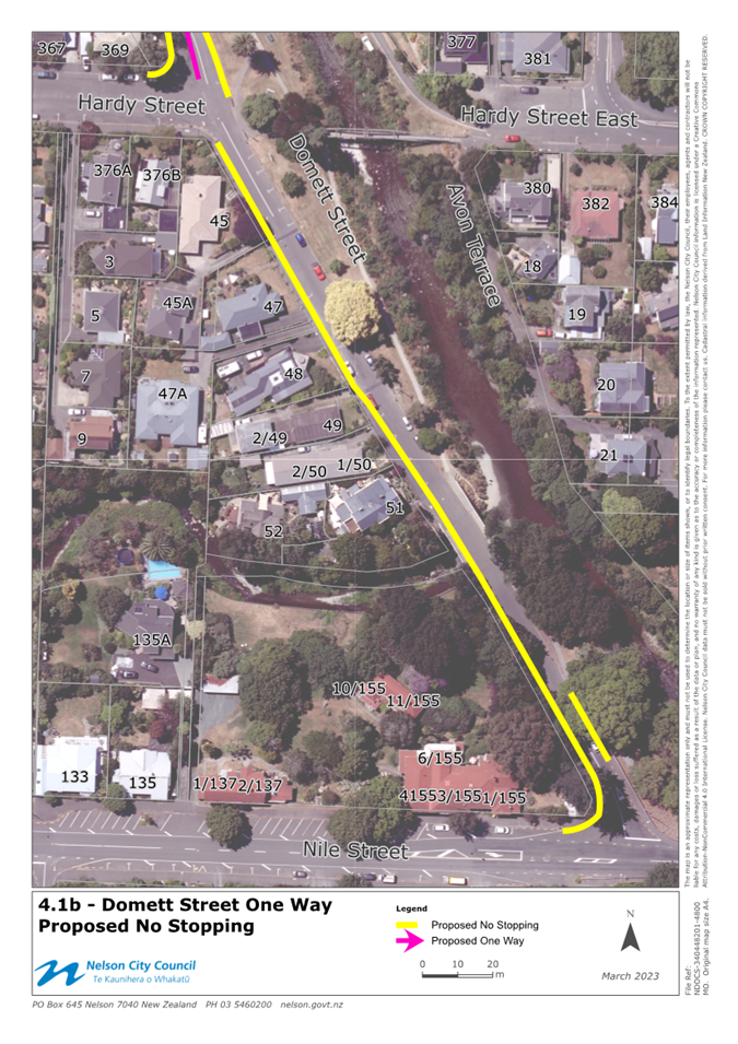
4.1 Domett Street –
One Way
Following consultation with
residents of Domett Street, officers have finalised the design for the Domett
Street improvements, which proposes to turn the northern section of Domett
Street (between Hardy and Tasman Streets) into a one-way road (northbound). To
make this layout enforceable, officers recommend adding this proposed one-way road
to the bylaw. The proposed one-way section of Domett Street is shown in
Attachment 1, titled 4.1a and 4.1b.
Schedule 4 – Special
parking Areas
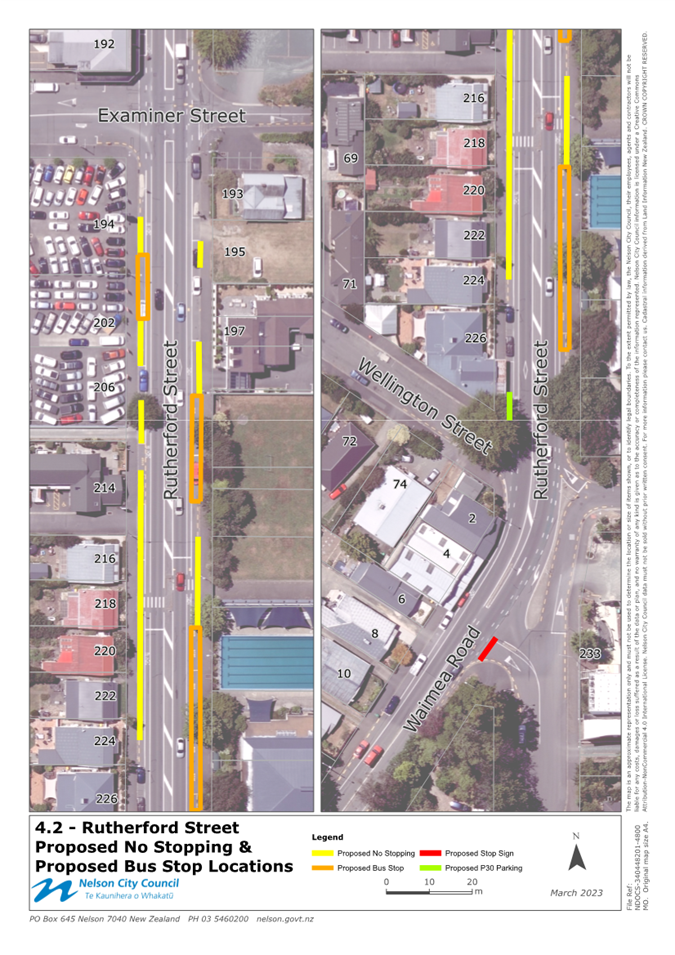
4.2 Rutherford Street -
Bus Stops
In conjunction with the recent
Rutherford St/Waimea Rd stormwater project, line marking improvements have been
made along Rutherford Street resulting in relocation of the northbound bus stop
to the north, and minor changes to the southbound bus stops to better align
with the nearby pedestrian crossing. Officers consulted on the wider changes
and worked with residents and businesses to achieve the best outcome based on
competing priorities. This layout has been implemented as part of the project
work and has achieved the desired outcomes of improving cyclist and pedestrian
safety in the area. The changes to the bus stops on Rutherford Street are shown
in attachment 1, titled 4.2 and require retrospective
approval to update bylaw schedules.
4.3 Hounsell Circle -
Mobility Carparks
Following completion of Te Pa
Harakeke, and the success of this new community facility, the need for a
designated mobility carpark has been identified. A new mobility carpark will
provide greater access for mobility card holders to enjoy this great new facility.
One mobility carpark is proposed within the existing parking area, closest to
the train station. The proposed mobility car park is shown in attachment 1,
titled 4.3.
4.4 Montgomery Carpark
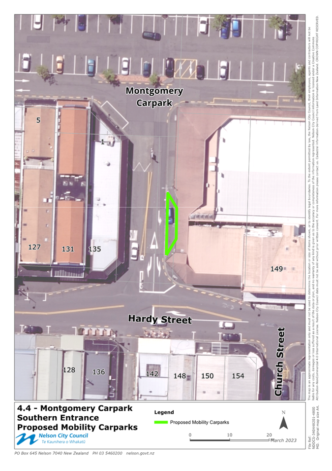
Entrance – Mobility Carparks
To support access to the Saturday
Market, officers have been working on several mobility carpark options that
compensate for those temporarily blocked when the Saturday market occupies
Montgomery Carpark. Officers have identified two carparks, close to the
Saturday market that have a limited impact on surrounding businesses. The
proposed Mobility Carparks are shown in attachment 1, titled 4.4. Officers
propose to make these carparks dual purpose, with mobility car parking on
Saturdays, and P5 time limited parking at all other times (current
restriction).
Schedule 8 – Time
Limited Parking Areas
4.5 Rutherford Street
– P30 Parking Area
In conjunction with the recent
Rutherford St/Waimea Rd stormwater project, line marking and signage
improvements have been made along Rutherford Street. This included updating the
current P10 time limited parking on the corner of Rutherford St / Wellington
St. The old time limit related to the nearby premise, being a dairy. Officers
discussed the parking needs with Rustic Cuisine (new business) and confirmed
that P30 parking would be more appropriate for their business model and
customers. This change has been implemented during reinstatement of Rutherford
Street and is working well. This update is shown in attachment 1, titled 4.2 and
requires retrospective approval to update bylaw schedules.
Schedule 9 – No
Stopping and No Parking Areas
4.6 Domett Street –
No Stopping
Following consultation with residents of Domett Street,
officers have now finalised the design for upgrading Domett Street, which
proposes to formalise parking and install strategic no stopping to improve
overall safety in the area. This no stopping is proposed in areas where parking
would either block visibility/access or unduly narrow the traffic lanes. The
proposed no stopping is shown in Attachment 1, titled 4.1.
4.7 Rutherford
Street/Waimea Road – No Stopping
In conjunction with the recent Rutherford St/Waimea Rd stormwater
project, line marking improvements have been made along Rutherford Street which
involved relocating bus stops, realigning cycle lanes, altering parking and
installing no stopping to support these changes. Officers sought feedback from
residents and businesses and adopted feedback to minimise overall impact. The
no stopping installed resulted in no loss of on-street carparking within this
stretch of road. The no stopping installed is shown in attachment 1, titled 4.2
and requires retrospective approval to update bylaw
schedules.
4.8 Hounsell Circle
– No Stopping
Following completion Te Pa Harakeke, and the success of
this new community facility, the need for no stopping in
Hounsell Circle has arisen to ensure that parking is used both safely and
efficiently. The proposed no stopping will ensure those accessing the
designated perpendicular parking area are not blocked in by vehicles parking
opposite. The proposed no stopping is shown in attachment 1, titled 4.3.
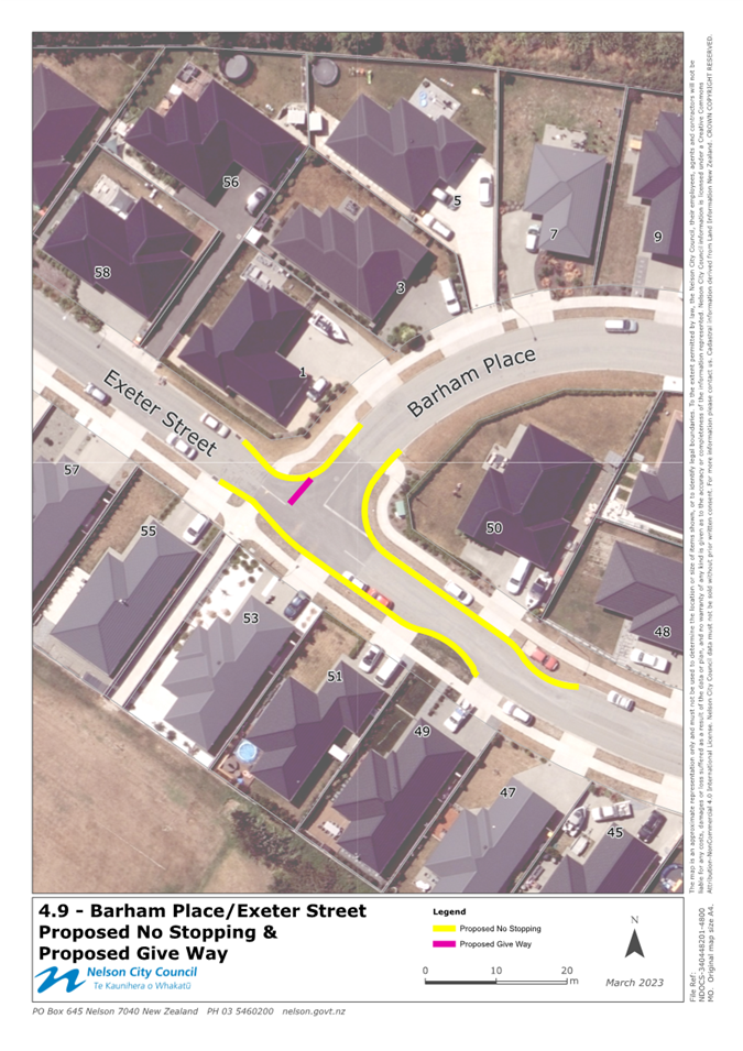
4.9 Barham Place/Exeter
Street – No Stopping
Following concerns raised
regarding parking and visibility near the Barham Place/Exeter Street intersection,
officers have reviewed options to improve safety whilst making the roading
environment more self-explanatory. Officers propose to change the priority so
that Exeter Street turns freely into Barham Place (as a continuation of either
road) and control the remaining section of Exeter Street (west of Barham Place)
under a Give Way. To support this change, no stopping is required to ensure
visibility to/from the corner and clear traffic lanes for larger vehicles using
this intersection. Officers letter dropped residents following an initial road
safety enquiry which generated one response. This feedback suggested Council
had not gone far enough with its no stopping proposal. This feedback has been
considered and included in the current proposal. The proposed no stopping is
shown in attachment 1, titled 4.9.
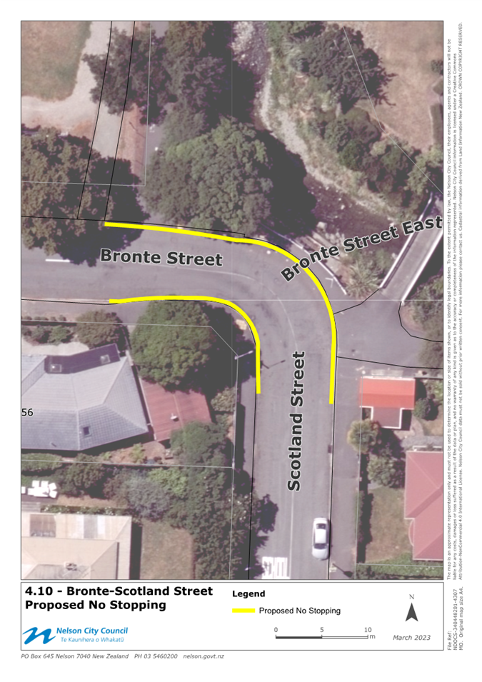
4.10 Bronte St / Scotland St –
No Stopping
Following concern raised
regarding the safety of school children and cyclists near the corner of Bronte
St and Scotland St, officers have been consulting with the community on a range
of options to improve visibility and overall safety where Shakespeare Walk
meets Bronte Street beside St Joseph’s school. Following three rounds of
feedback, officers are recommending installing the no stopping shown in attachment
1, titled 4.10. Ensuring no vehicles stop/park on this corner will enable
greater visibility between vehicles, cyclists and pedestrians, particularly
during school pick-up time when a larger number of traffic movements
concentrate in this area.
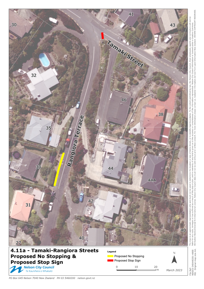
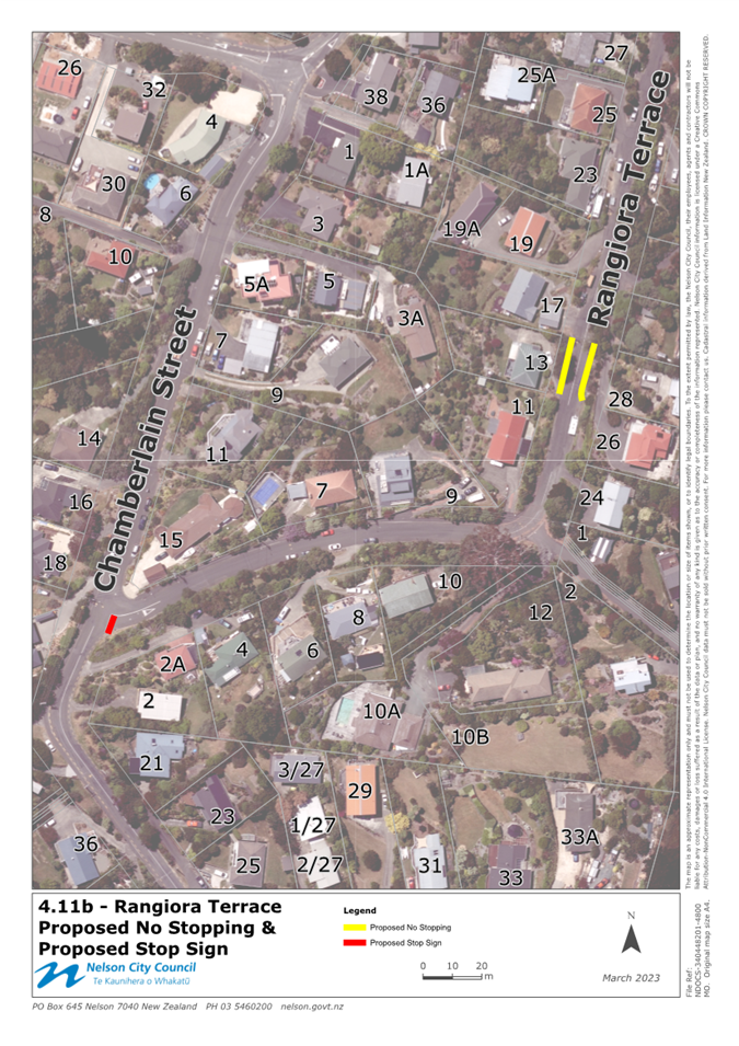
4.11 Port Hills Traffic Calming
– No Stopping
Following concerns raised by
southern Tahunanui Hills residents, officers have been working with residents
to lower speeds and improve safety along Stansell Ave and Tosswill Ave, which
includes several side streets. Officers held a community meeting onsite and
have engaged with these residents through letter drops and face to face
meetings. Following this engagement work, officers have completed a detailed
design and are in the process of procuring a contractor to carry out the
installation of speed humps, signage, and line marking. No Stopping is proposed
in various areas along these roads, as shown in attachment 1, titled 4.11a and
4.11b.
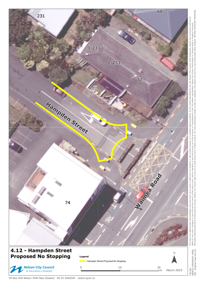
4.12 Hampden Street Turning Head
– No Stopping
Following Council’s
decision to make the Hampden Street closure permanent, officers have designed
and are soon to install a ‘hammer-head’ style turning head where
Hampden Street historically met Waimea Road. To ensure this turning head works
safety and efficiently, no stopping is required to prohibit parking within the
turning area. The proposed no stopping is shown in attachment 1, titled 4.12
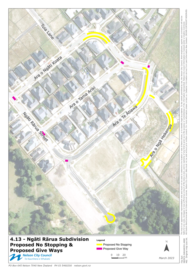
4.13 Ngāti Rārua Subdivision
– No Stopping
Following construction and
vesting of new roads through the subdivision process, Council needs to accept
into its parking and vehicle control bylaw, new restrictions on roads that are
now within Nelson City Council’s control. Several roads within the Ngāti
Rārua subdivision have been or are soon to be vested in Council. Officers
recommend adding the no stopping, as shown in Attachment 1, titled 4.13, to the
bylaw to ensure these restrictions are enforceable.
4.14 235 Bridge Street – No
Stopping
Concern has been raised
regarding parking that occurs between the driveway to 2/235 Bridge St and
villas within Green Gables retirement village. The distance between driveways
is such that larger vehicles frequently overhang the kerb dropdown, which makes
access to and from these driveways difficult. Officers have trialled a white
parking triangle in this location but are finding that this parking behaviour
continues to occur. Therefore, officers are proposing to install no stopping as
the next course of action, as shown in Attachment 1, titled 4.14. Green Gables
support this proposal.
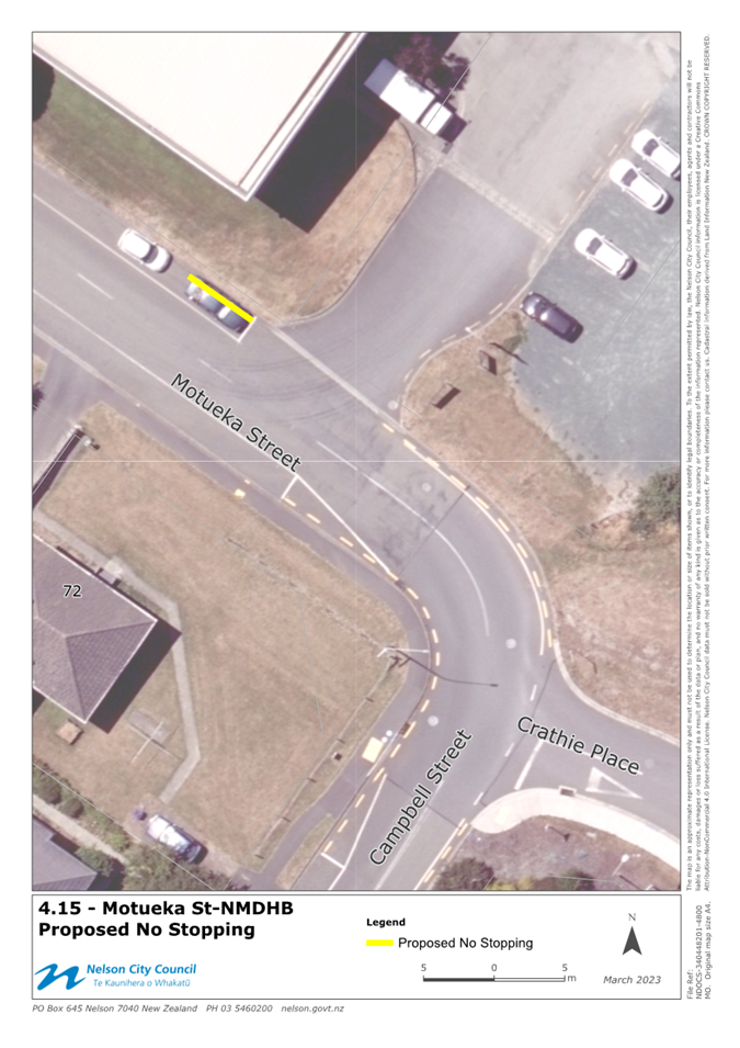
4.15 Motueka Street (East) – No
Stopping
Officers have been approached by
Te Whatu Ora, raising concern about parking near the maintenance/laundry
driveway in Motueka Street. Officers have been working with hospital staff and
have recently seen some safety improvements installed on hospital land. To
further support safe entry and exit of this driveway, officers propose the
installation of no stopping to the west of this driveway, as shown in
attachment 1, titled 4.15. Removal of this parking will improve visibility when
exiting the driveway. Te Whatu Ora support this proposal.
4.16 57 Parkers Rd – No Stopping
Concern has been raised
regarding parking that occurs between the two driveways servicing 57 Parkers
Road. The distance between driveways is such that vehicles frequently overhang
the kerb dropdown, which makes access to and from the business difficult.
Officers have trialled a white parking triangle in this location but are
finding that this parking behaviour continues to occur. Therefore, officers are
proposing to install no stopping as the next course of action, as shown in
Attachment 1, titled 4.16. 57 Parkers Road are the applicant of this no
stopping, and therefore support this installation.
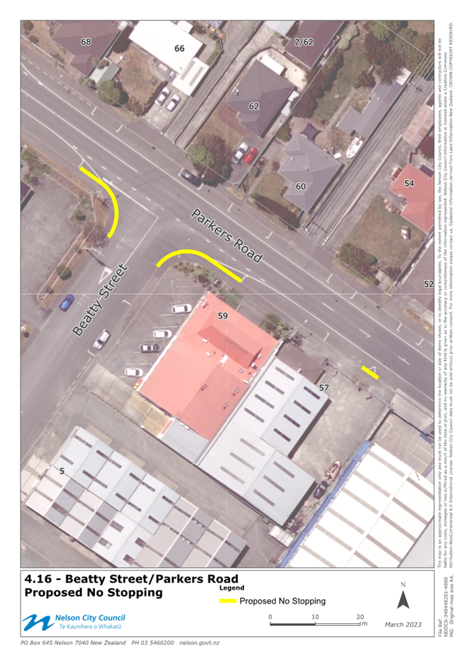
4.17 Beatty St / Parkers Road –
No Stopping
Officers are frequently
contacted regarding parking that occurs around the Beatty Street and Parkers
Road corners. Parking frequently occurs closer than 6m to the corners, and at
times has blocked the footpath road crossing points. To reinforce these no
stopping areas (where vehicles cannot legally park), officers propose to
install no stopping lines, 6m from the intersection on both corners of Beatty
Street and Parkers Road. No formal feedback was sought as this behaviour is in
breach of existing parking regulation. The proposed no stopping is shown in
attachment 1, titled 4.16.
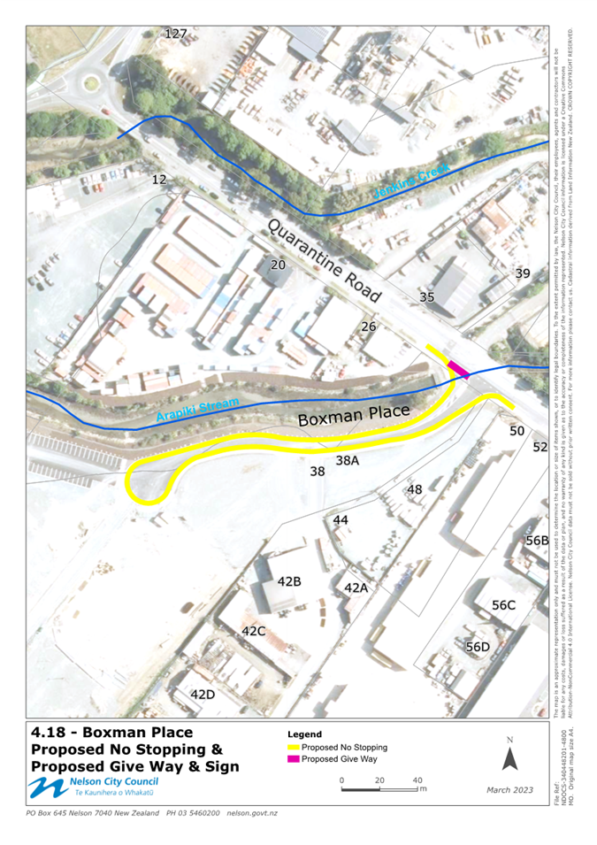
4.18 Boxman Place – No Stopping
Following construction and
vesting of new roads through the subdivision process, Council needs to accept
into its parking and vehicle control bylaw, new restrictions on roads that are
now within Nelson City Council’s control. Boxman Place subdivision has
now been vested in Council, and officers recommend adding the no stopping, as
shown in Attachment 1, titled 4.18, into this bylaw to ensure these
restrictions are enforceable.
4.19 518 Waimea Road – No
Stopping
Officers have been approached by
the resident at 516 Waimea Road who raises concern about vehicles parking
directly east of the bus stop near 518 Waimea Road. Parking within the indented
bus stop makes merging with traffic more difficult for buses and obstructs
visibility when exiting the driveway of 516 Waimea Road. Officers have letter
dropped residents seeking feedback regarding this proposal, and at the time of
writing this report, feedback is pending. Any feedback received will be tabled
at the hearing panel meeting. The proposed no stopping is shown in attachment
1, titled 4.19.
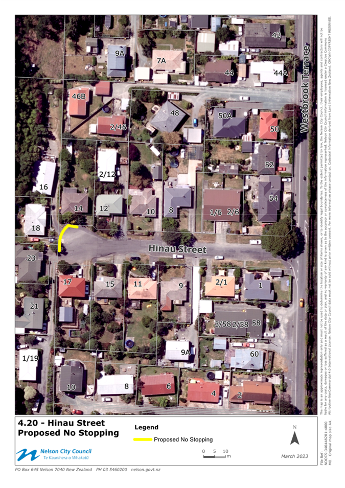
4.20 Hinau St – No Stopping
Following discussions with a
resident of Hinau Street, it was identified that the no stopping situated in
Hinau Street was incorrectly entered into the bylaw schedules. The bylaw
currently shows the no stopping starting 110 metres from Westbrook Terrace,
extending for 17m along the right-hand side of Hinau Street. This measurement
should in fact be 101m from Westbrook Terrace, extending 17m along the right-hand
side of Hinau Street. Once this anomaly was identified, officers have sought to
rectify and update this to ensure the no stopping can be correctly enforced.
The no stopping was first entered into the current bylaw in 2007 and is still
required to ensure the safe and efficient turning of vehicles of Hinau Street.
The no stopping (as it is marked currently) is shown in attachment 1, titled
4.20.
4.21 Hill Tops Way – No Stopping
Following construction and vesting of new roads through the
subdivision process, Council needs to accept into its parking and vehicle
control bylaw, new restrictions on roads that are now within Nelson City
Council’s control. Several roads within the Ngawhatu subdivision have now
been or vested to Council. Officers therefore recommend adding the no stopping,
as shown in Attachment 1, titled 4.21, into this bylaw to ensure these
restrictions are enforceable.
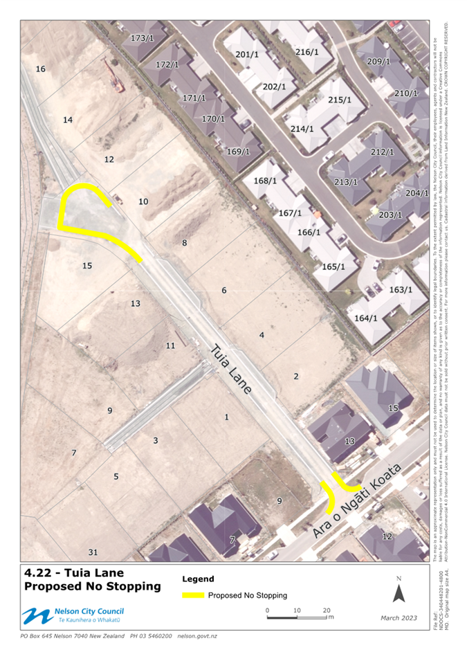
4.22 Tuia Lane – No Stopping
Following construction and vesting of new roads through the
subdivision process, Council needs to accept into its parking and vehicle
control bylaw, new restrictions on roads that are now within Nelson City
Council’s control. Tuia Lane has now been vested in Council, and officers
therefore recommend adding the no stopping, as shown in Attachment 1, titled 4.22,
into this bylaw to ensure these restrictions are enforceable.
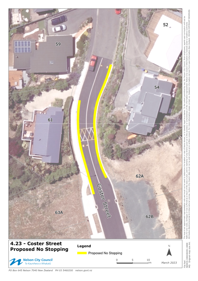
4.23 Coster Street – No Stopping
Following construction and vesting of new roads through the
subdivision process, Council needs to accept into its parking and vehicle
control bylaw, new restrictions on roads that are now within Nelson City
Council’s control. Coster Street has now been vested in Council, and
officers therefore recommend adding the no stopping, as shown in Attachment 1,
titled 4.23, into this bylaw to ensure these restrictions are enforceable.
4.24 Wansford Place – No
Stopping
Following construction and vesting of new roads through the
subdivision process, Council needs to accept into its parking and vehicle
control bylaw, new restrictions on roads that are now within Nelson City
Council’s control. Wansford Place has now been vested in Council, and
officers therefore recommend adding the no stopping, as shown in Attachment 1,
titled 4.24, into this bylaw to ensure these restrictions are enforceable.
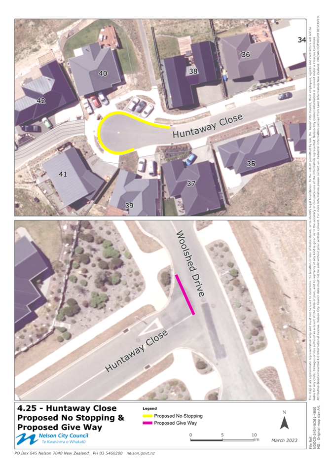
4.25 Huntaway Close – No
Stopping
Following construction and vesting of new roads through the
subdivision process, Council needs to accept into its parking and vehicle
control bylaw, new restrictions on roads that are now within Nelson City
Council’s control. Huntaway Close has now been vested in Council, and
officers therefore recommend adding the no stopping, as shown in Attachment 1,
titled 4.25, into this bylaw to ensure these restrictions are enforceable.
4.26 Ledger Road – No Stopping
Following construction and
vesting of new roads through the subdivision process, Council needs to accept
into its parking and vehicle control bylaw, new restrictions on roads that are
now within Nelson City Council’s control. Ledger Road has now been vested
in Council, and officers therefore recommend adding the no stopping, as shown
in Attachment 1, titled 4.26, into this bylaw to ensure these restrictions are
enforceable.
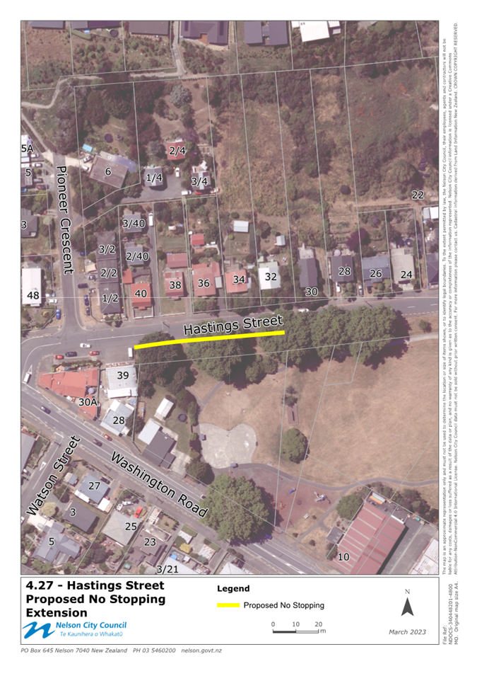
4.27 Hastings Street – No
Stopping
During the reconstruction of
Hasting Street, officers are seeking to update road markings to better
formalise the road layout and prohibit parking under the heritage trees along
Pioneer Park. Officers propose to increase the length of no stopping currently
included within the bylaw to encompass the full length of heritage trees, which
will prohibit parking near these iconic trees, on top of the various tree
roots, and along the un-sealed edge of Hastings Street. Residents have been
informed of the proposed parking layout through regular project letter drops.
The proposed no stopping is shown in attachment 1, titled 4.27.
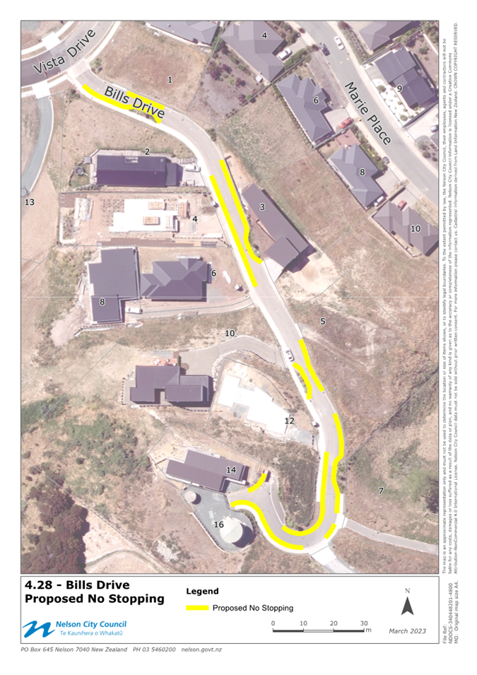
4.28 Bills Drive – No Stopping
Following construction and
vesting of new roads through the subdivision process, Council needs to accept
into its parking and vehicle control bylaw, new restrictions on roads that are
now within Nelson City Council’s control. Bills Drive has now been vested
in Council, and officers therefore recommend adding the no stopping, as shown
in Attachment 1, titled 4.28, into this bylaw to ensure these restrictions are
enforceable.
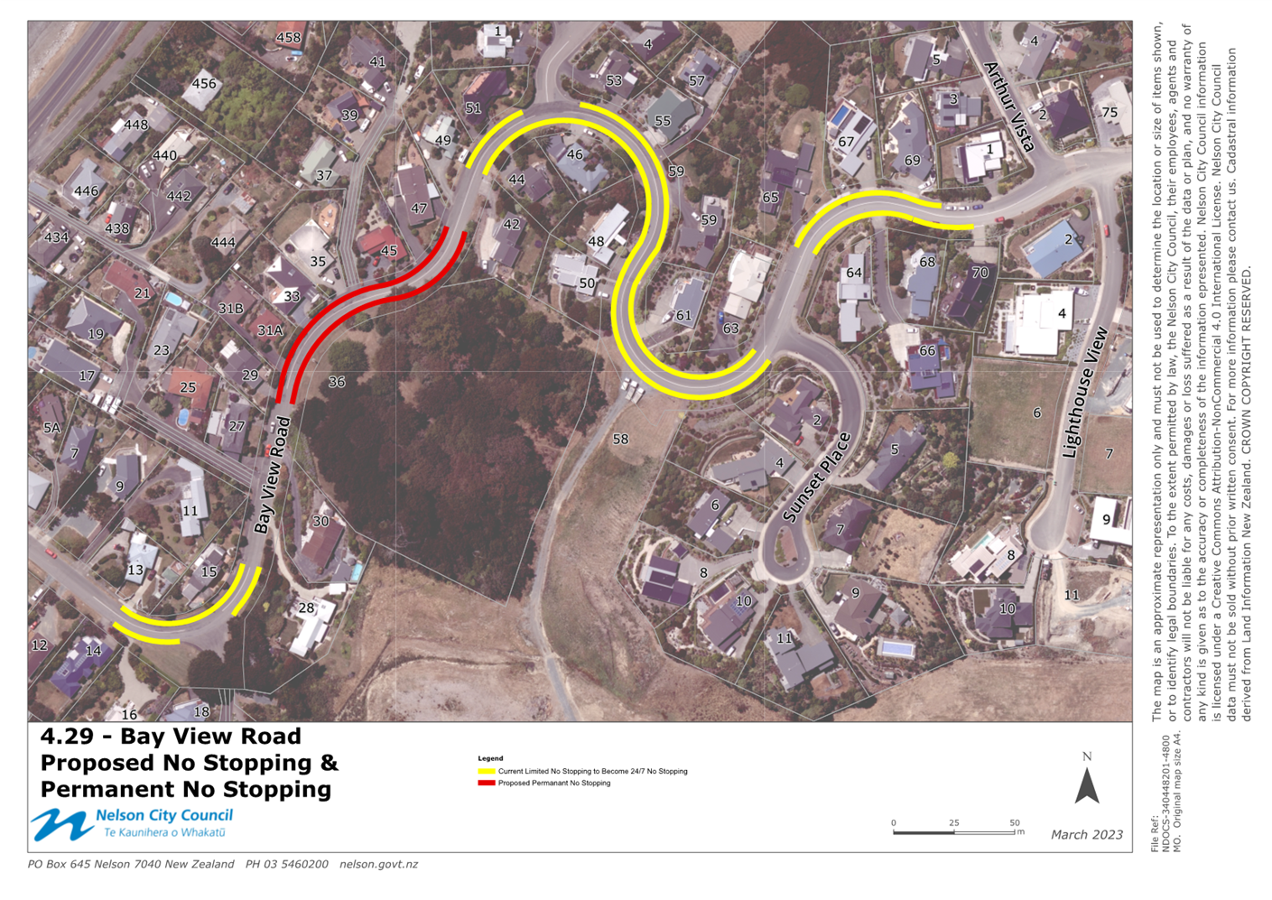
4.29 Bay View Road – No Stopping
4.29.1 Bay View Road has been developed in stages over a
number of decades (from the 1950s). Different stages of the road have been
designed and built in accordance with the version of Council’s
Engineering Standards or Land Development Manual (LDM) current at the time of
development. The road width varies from 7.5m to 9.1m but is generally
consistent with the requirements of a Sub-Collector road classification. There
are several comparatively tight curves over the length of Bay View Road.
4.29.2 Concerns have been raised by residents regarding
the fact that they need to cross the road centreline when passing parked
vehicles, and that there is inadequate sight distance to see vehicles
approaching. The presence of heavy vehicles, and general increase in traffic
associated with the current stage of development has highlighted these issues
further.
4.29.3 Parking restrictions were introduced to Bay View
Road early in 2022 as a trial. These prohibited parking from 8:00 am to 5:00 pm
Monday to Friday. Council has sought feedback from residents regarding their
experience with the current parking restrictions, and whether those
restrictions should be removed, retained, or be extended. Engagement included a
direct letter drop and the Shape Nelson feedback page.
4.29.4 A large amount of detailed feedback has been
gathered analysed and this, coupled with knowledge that further development is
occurring at the top of Bay View Road, has led officers to propose installation
of no stopping as shown in Attachment 1, titled 2.29.
Schedule 13 – Stop Signs
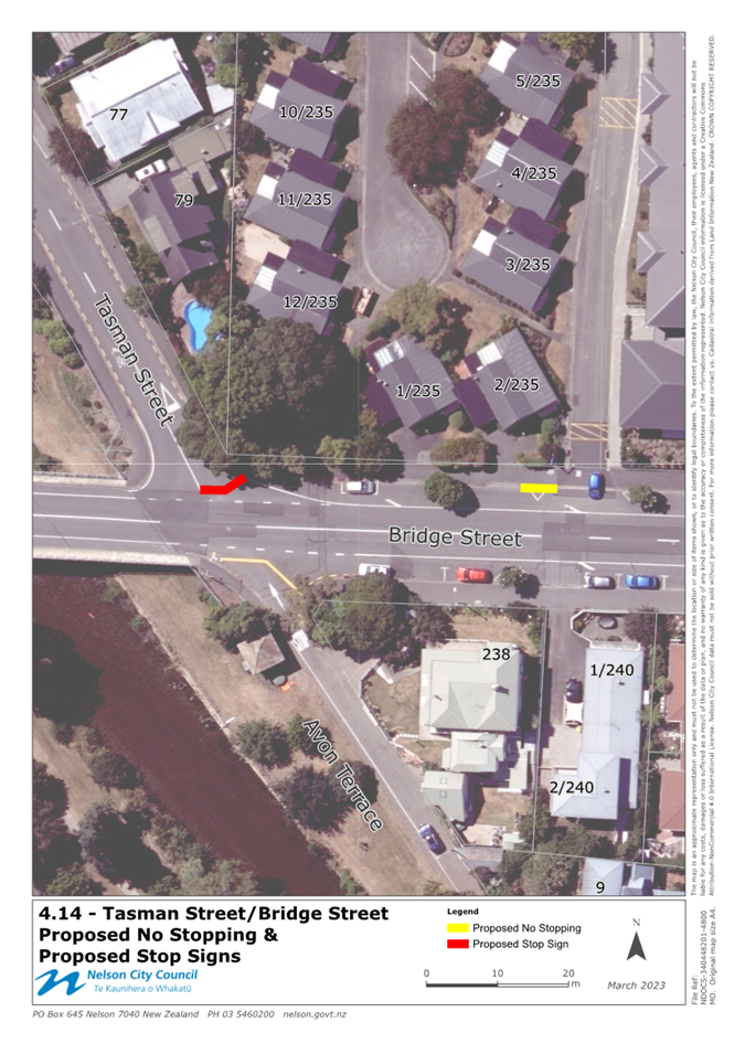
4.30 Tasman St / Bridge St –
Stop Sign
Officers propose to change the
Bridge Street / Tasman Street intersection from a Give Way Sign to a Stop Sign.
This intersection does not comply with the minimum visibility requirements for
a Give Way sign, and following onsite observations and customer enquiries,
officers propose making this change to highlight the need to stop at this
intersection. The proposed stop sign is shown in attachment 1, titled 4.14.
Police have provided their support for this proposal.
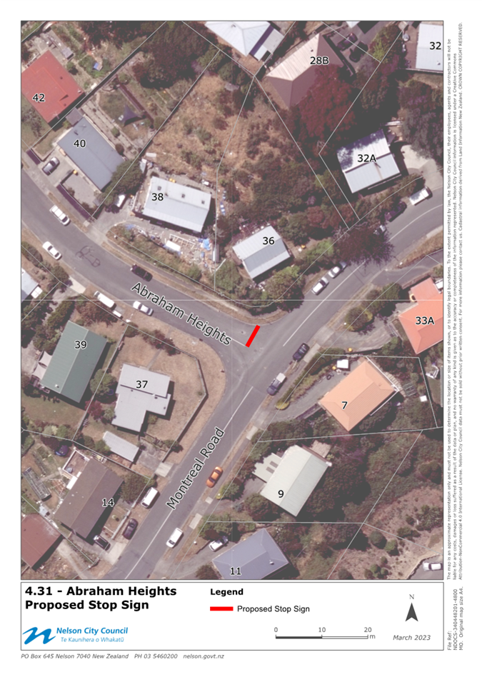
4.31 Abraham Heights – Stop Sign
Officers propose to formalise
the Abraham Heights intersection with Montreal Road (currently an un-controlled
Give Way) with a Stop Sign. Visibility when exiting Abraham heights is limited
due to road geometry, and officers recommend installing a Stop Sign at this
intersection. The proposed Stop Sign is shown in attachment 1, titled 4.31.
Police have provided their feedback on this proposal which noted that this
intersection should be controlled. Police suggested placing this intersection
on Give Way Sign, however officers recommend a Stop Sign in this location in
accordance with the required standard for visibility at an intersection.
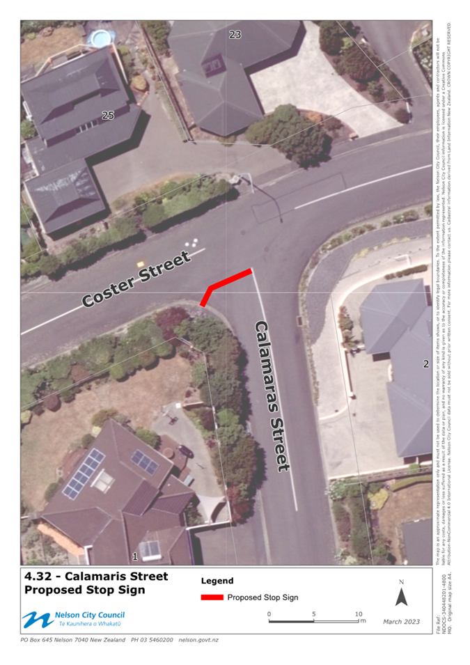
4.32 Calamaras St – Stop Sign
Following feedback regarding
limited visibility when exiting Calamaras Street, officers have identified and
now propose to place Calamaras Street, at the Calamaras St / Coster St
intersection, on a Stop Sign. The proposed stop sign is shown in attachment 1,
titled 4.32. Police have provided their support for this proposal.
4.33 Rutherford St / Waimea Road
– Stop Sign
In conjunction with the recent
Rutherford St/Waimea Rd stormwater project, safety improvements have been made
to the intersection of Rutherford St and Waimea Road. This included realigning
Rutherford Street intersection and replacing the current Give Way with a Stop
Sign. Given the high traffic volume and complexity of this intersection,
officers have reinstated this intersection using a Stop Sign to improve safety.
The Stop Sign installed is shown in attachment 1, titled 4.2 and requires
retrospective approval to update bylaw schedules. Police have provided their
support for this proposal.
4.34 Tamaki St / Tosswill Rd –
Stop Signs
Following concerns raised by southern Tahunanui Hills
residents, officers have been working with residents to lower speeds and
improve safety along Stansell Ave and Tosswill Ave, and several side streets
(as mentioned previously). Included within this project, safety improvements
have been identified at the Tamaki Street / Tosswill Road intersection which
involves changing both legs of Tamaki Street from Give Way to Stop Signs. The
proposed Stop Signs are shown in attachment 1, titled 4.34. Police have provided
their support for this proposal.
4.35 Tamaki St / Rangiora Tce /
Chamberlain St – Stop Signs
Following concerns raised by southern Tahunanui Hills
residents, officers have been working with residents to lower speeds and
improve safety along Stansell Ave and Tosswill Ave, and several side streets
(as mentioned previously). Included within this project, safety improvements
have been identified at the Tamaki Street / Rangiora Terrace and Rangiora
Terrace / Chamberlain Street intersections. Officers propose to place Tamaki
Street (east of Rangiora Terrace) on a Stop Sign, and Rangiora Terrace /
Chamberlain Street on a Stop Sign to improve safety and reduce driver confusion
at this intersection. The proposed Stop Signs are shown in attachment 1, titled
4.11a and 4.11b. Police have provided their support for this proposal.
Schedule 14 – Give Way
Signs
4.36 Boxman Place – Give Way
Sign
Following construction and
vesting of Boxman Place in Council, the Give Way Sign associated with this new
road needs to be reflected in Council’s bylaw to ensure this traffic
restriction is enforceable. The Give Way Sign is shown in attachment 1, titled
4.18.
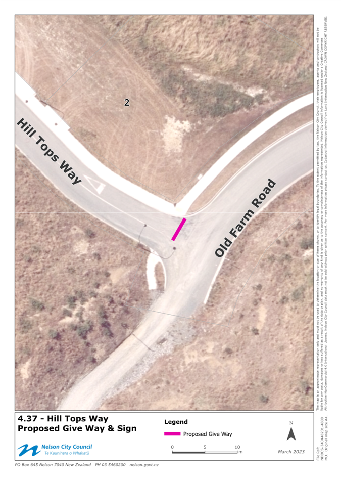
4.37 Hill Tops Way – Give Way
Sign
Following construction and vesting of Hill Tops Way in
Council, the Give Way Sign associated with this new road needs to be reflected
in Council’s bylaw to ensure this traffic restriction is enforceable. The
Give Way Sign is shown in attachment 1, titled 4.37.
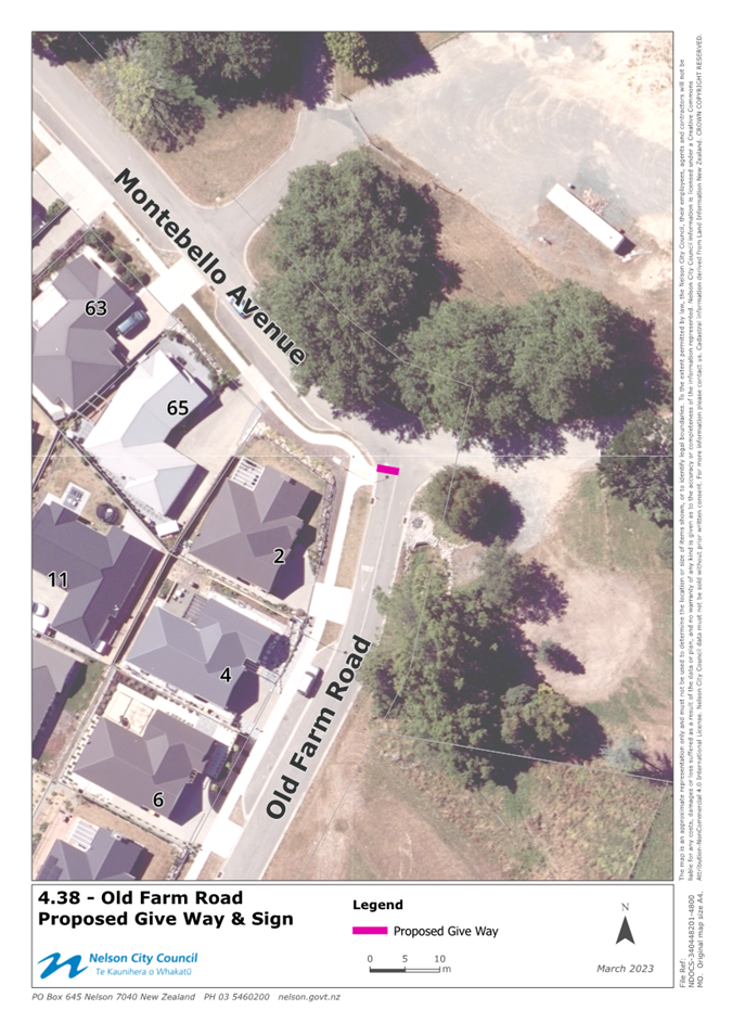
4.38 Old Farm Road – Give Way
Sign
Following construction and vesting of Old Farm Road in
Council, the Give Way Sign associated with this new road needs to be reflected
in Council’s bylaw to ensure this traffic restriction is enforceable. The
Give Way Sign is shown in attachment 1, titled 4.38.
4.39 Greenfield Lane – Give Way
Sign
Following construction and vesting of Greenfield Lane in
Council, the Give Way Sign associated with this new road needs to be reflected
in Council’s bylaw to ensure this traffic restriction is enforceable. The
Give Way Sign is shown in attachment 1, titled 4.39.
4.40 Ara O Ngāti Koata –
Give Way Signs
Following construction and vesting of Ara O Ngāti
Koata in Council, the
Give Way Sign associated with this new road needs to be reflected in Council’s
bylaw to ensure this traffic restriction is enforceable. The Give Way Sign is
shown in attachment 1, titled 4.13.
4.41 Ara o Tama Ariki – Give Way
Signs
Following construction and vesting of Ara o Tama Ariki in
Council, the Give Way Sign associated with this new road needs to be reflected
in Council’s bylaw to ensure this traffic restriction is enforceable. The
Give Way Sign is shown in attachment 1, titled 4.13.
4.42 Oak Hill Lane – Give Way
Sign
Following construction and vesting of Ara o Tama Ariki in
Council, the Give Way Sign associated with this new road needs to be reflected
in Council’s bylaw to ensure this traffic restriction is enforceable. The
Give Way Sign is shown in attachment 1, titled 4.13.
4.43 Wansford Place – Give Way
Sign
Following construction and vesting of Wansford Place in
Council, the Give Way Sign associated with this new road needs to be reflected
in Council’s bylaw to ensure this traffic restriction is enforceable. The
Give Way Sign is shown in attachment 1, titled 4.24.
4.44 Huntaway Close – Give Way
Sign
Following construction and vesting of Huntaway Close in
Council, the Give Way Sign associated with this new road needs to be reflected
in Council’s bylaw to ensure this traffic restriction is enforceable. The
Give Way Sign is shown in attachment 1, titled 4.25.
4.45 Exeter Street/Barham Place - Give
Way Sign
Following concerns raised
regarding parking and visibility near the Barham Place / Exeter Street
intersection, officers have reviewed options to improve safety whilst make the
roading environment more self-explaining. Officers propose to change the
priority so that Exeter Street turns freely into Barham Place (as a
continuation of both roads), and control the remaining section of Exeter Street
(west of Barham Place) under a Give Way Sign. The proposed Give Way Sign is
shown in attachment 1, titled 4.9.
5. Options
5.1 There are limited
options for the items presented in this report as the changes in schedules 1,
4, 8, 9 13 and 14 are proposed changes to improve safe traffic movement and
access. Option 1 is the recommended option.
|
|
|
Advantages
|
· Changes
to Schedules are designed to improve safety and efficiency
|
|
Risks and Disadvantages
|
· Minor
loss of parking
|
|
|
|
Advantages
|
· There
are no identified advantages
|
|
Risks and Disadvantages
|
· Failure
to approve changes will result in the continued unsafe and inefficient use of
the roading network.
· Changes
implemented through the subdivision and capital works programme will not be
enforceable.
|
Author: Matt
Bruce, Team Leader Transport and Solid Waste
Attachments
Attachment 1: 1355221503-8263
- Proposed Changes Shown Indicatively on Aerials ⇩
Attachment 2: 1355221503-8016
- Schedule of Changes to the Parking and Vehicle Control Bylaw ⇩
|
Important considerations for decision making
|
|
Fit with Purpose of Local Government
The report recommendation meets current and future
needs of communities in contributing to the safe use of the roading and
parking network in the City.
|
|
Consistency with Community Outcomes and Council Policy
The content and recommendations of this report are
consistent with Councils Community Outcomes – “Our Infrastructure
is efficient, cost effective and meets current and future needs”. In
particular that we have good quality, affordable and effective
infrastructure, and transport networks. This report is directly aligned to
the requirements of the Parking Policy, the Parking and Vehicle Control Bylaw
and with Council’s strategic direction through the Regional Land
Transport Strategy.
|
|
Risk
To ensure that the Bylaw is enforceable, it is
important to ensure that the Schedules are updated on a regular basis.
Failure to update Schedules will open enforcement up to challenge.
|
|
Financial impact
Costs are within allocated annual budgets for road
maintenance or capital projects.
|
|
Degree of significance and level of engagement
This matter is of low significance. Nearby
businesses and residents that could be affected, have been consulted where
required.
|
|
Climate Impact
Not applicable for safe and efficient operation of
Councils existing transport network.
|
|
Inclusion of Māori in the decision making process
No engagement with Maori has been
undertaken in preparing this report. No engagement with Maori has been
undertaken in preparing this report.
|
|
Delegations
The Hearings Panel has the following delegations to
consider changes to the Parking and vehicle Control Bylaw.
Powers to Decide:
The power to make changes to the schedules to
the Parking and Vehicle Control Bylaw.
|