Notice of the Ordinary meeting of
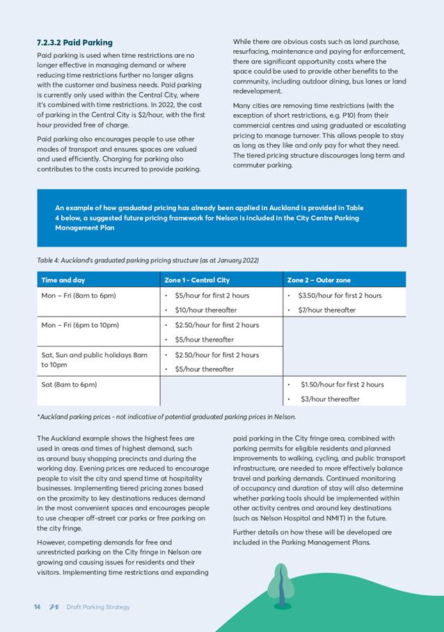
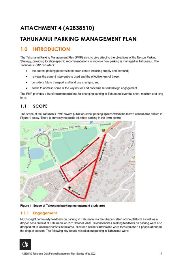
Infrastructure Committee
Te Kōmiti Hanganga
|
Date: Thursday
31 March 2022
Time: 9.00a.m.
Location: via
Zoom
|
Agenda
Rārangi take
Chairperson Cr
Brian McGurk
Deputy
Chairperson Cr
Rohan O'Neill-Stevens
Members Her
Worship the Mayor Rachel Reese
Cr
Yvonne Bowater
Cr
Trudie Brand
Cr
Mel Courtney
Cr
Judene Edgar
Cr
Kate Fulton
Cr
Matt Lawrey
Cr
Gaile Noonan
Cr
Pete Rainey
Cr
Rachel Sanson
Cr
Tim Skinner
Quorum 7 Pat
Dougherty
Chief Executive
Nelson City Council Disclaimer
Please note that the contents of these
Council and Committee agendas have yet to be considered by Council and officer
recommendations may be altered or changed by the Council in the process of making
the formal Council decision. For enquiries call (03) 5460436.
Infrastructure Committee
Areas of
Responsibility:
·
Bylaws, within the areas of responsibility
·
Recycling
·
Regional Landfill
·
Solid Waste management, including transfer stations and waste
minimisation
·
Stormwater and Flood Protection
·
Transport network, including, roading network and associated
structures, walkways, cycleways and shared pathways, footpaths and road
reserve, street lighting, traffic management control and parking.
·
Wastewater, including Bell Island Wastewater Treatment Plant
·
Water
Delegations:
The committee has all of the
responsibilities, powers, functions and duties of Council in relation to
governance matters within its areas of responsibility, except where they have
been retained by Council, or have been referred to other committees, subcommittees
or subordinate decision-making bodies.
The exercise of Council’s
responsibilities, powers, functions and duties in relation to governance
matters includes (but is not limited to):
·
Monitoring Council’s performance for the committee’s
areas of responsibility, including legislative responsibilities and compliance
requirements
·
Developing, monitoring and reviewing strategies, policies and
plans, with final versions to be recommended to Council for approval
·
Developing and approving draft Activity Management Plans in
principle, including the Infrastructure Strategy, for inclusion in the draft
Long Term Plan
·
Reviewing and determining whether a bylaw or amendment,
revocation or replacement of a bylaw is appropriate
·
Undertaking community engagement, including all steps relating to
Special Consultative Procedures or other formal consultation processes
·
Approving submissions to external bodies or organisations, and on
legislation and regulatory proposals
·
Hear, consider and decide all applications for road stopping
·
Approval of increases in fees and charges over the Consumer Price
Index (CPI)
Powers to
Recommend to Council:
In the following situations the
committee may consider matters within the areas of responsibility but make
recommendations to Council only (in accordance with sections 5.1.3 - 5.1.5 of
the Delegations Register):
·
Matters that, under the Local Government Act 2002, the operation
of law or other legislation, Council is unable to delegate
·
The purchase or disposal of land or property relating to the
areas of responsibility, other than in accordance with the Long Term Plan or
Annual Plan
·
Unbudgeted expenditure relating to the areas of responsibility,
not included in the Long Term Plan or Annual Plan
·
Decisions regarding significant assets
·
Approval of final versions of strategies, policies and plans
31
March 2022
Page
No.
Karakia
and Mihi Timatanga
1. Apologies
An apology has been received from
Her Worship the Mayor R Reese
2. Confirmation
of Order of Business
3. Interests
3.1 Updates
to the Interests Register
3.2 Identify
any conflicts of interest in the agenda
4. Public
Forum
5. Confirmation
of Minutes
5.1 24
February 2022 9 - 15
Document number M19261
Recommendation
|
That the Infrastructure Committee
1. Confirms the minutes of the meeting
of the Infrastructure Committee, held on 24 February 2022, as a true and
correct record.
|
6. Chairperson's Report
7. Draft Parking
Strategy - Approval to seek public feedback 16
- 90
Document number R26375
Recommendation
|
That
the Infrastructure Committee
1. Receives
the report Draft Parking Strategy - Approval to seek public feedback (R26375) and its attachments (A2862519,
A2838508, A2838509, A2838510 and A2844394); and
2. Agrees to seek public feedback on
the Draft Parking Strategy (A2862519) and the Draft Parking Management Plans
(A2838508, A2838509 and A2838510); and
3. Agrees that the Draft Parking
Strategy engagement process and public feedback opportunities meet the
requirements of the Local Government Act 2002 including the principles of
consultation in section 82; and
4. Approves the Draft Parking Strategy
(A2862519) and Draft Parking Management Plans (A2838508, A2838509 and
A2838510) for public feedback; and
5. Delegates to the Chair, Deputy
Chair and Chief Executive to approve any minor amendments required to the
supporting information or public feedback materials prior to the start of the
consultation process; and
6. Approves the consultation approach
set out in section 8 (attachment A2844394) of this report (R26375); and
7. Notes
the approach includes sufficient steps to ensure the Draft Parking Strategy
and proposed Parking Management Plans will be reasonably accessible to the
public and will be publicised in a manner appropriate to its purpose and
significance.
|
8. Pride Crossing - Way
Forward 91 - 108
Document number R26253
Recommendation
|
That the Infrastructure Committee
1. Receives the report Pride Crossing
- Way Forward (R26253) and its attachments (A2749080, A2773987, A2829334 and
A2829335); and
2. Approves either:
a) a pride crossing, as a permanent feature,
on the Central Trafalgar Street courtesy crossing (opposite Bank Lane) at an
estimated cost of $15,000;
OR
b) Revokes Resolution IC/2021/001 of the Infrastructure
Committee meeting held on 25 February 2021:
“Approves
the installation of a Progress Pride design on a central city raised courtesy
crossing as a permanent feature”; then
3. Approves
the installation of a pride decal on either the Trafalgar Street bike rack
and/or Montgomery Square bike rack at an estimated cost of $4,000 or $8,000
respectively.
|
9. Sandbag Policy
Options 109 - 120
Document number R26525
Recommendation
|
That
the Infrastructure Committee
1. Receives the report Sandbag Policy Options
(R26525) and its attachments
(A2840348, A2840350).
|
Recommendation to Council
|
That the Council
1. Confirms that Council does not
support the general provision of sandbags, sand or bags, to private property
owners/occupants prior to or during flood events; and
2. Notes
that officers are working in conjunction with the Nelson Tasman Emergency
Management Group to promote flood readiness to the community, and
specifically to those property owners located within the flood hazard/coastal
inundation overlay.
|
10. Hampden Street (west)
Intersection with Waimea Road- Long term closure to motor vehicles 121 - 131
Document number R26581
Recommendation
|
That
the Infrastructure Committee
1. Receives
the report Hampden Street (west) Intersection with Waimea Road-
Long term closure to motor vehicles (R26581) and its attachment (A2846492); and
2. Determines
that the intersection of Waimea Road and Hampden Street (west) be closed to
vehicular traffic long-term by determining under section 319(1)(f) of the
Local Government Act 1974 that part of the Hampden Street road west of Waimea
Road is a footpath and cycle track.
|
Recommendation to Council
|
That the Council
1. Approves
that the intersection of Waimea Road and Hampden Street (west) be closed to
vehicular traffic long-term by determining under section 319(1)(f) of the
Local Government Act 1974 that part of the Hampden Street (west) road is
footpath and cycle track.
|
11. Nelson Tasman Regional Landfill
Business Unit 2022/23 Business Plan 132 - 154
Document number R26658
Recommendation
|
That
the Infrastructure Committee
1. Receives the report Nelson Tasman Regional
Landfill Business Unit 2022/23 Business Plan (R26658) and its attachment (A2796488).
|
12. Nelson Regional Sewerage
Business Unit 2022/23 Business Plan 155 - 173
Document number R26659
Recommendation
|
That
the Infrastructure Committee
1. Receives the report Nelson Regional Sewerage
Business Unit 2022/23 Business Plan (R26659)
and its attachment (A2728794).
|
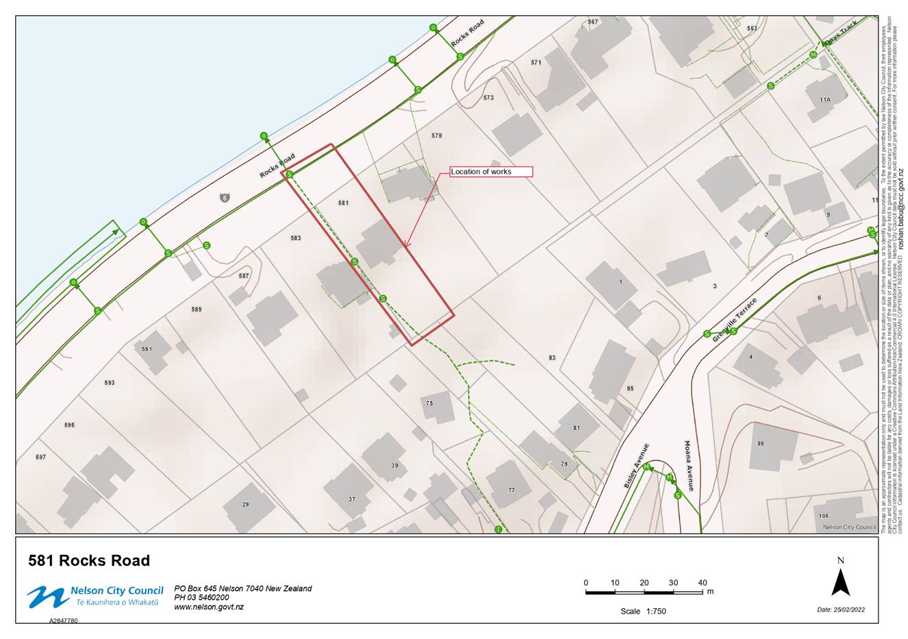
13. Tahunanui Catchment 4
Stormwater 174 - 179
Document number R26642
Recommendation
|
That
the Infrastructure Committee
1. Receives the report
Tahunanui Catchment 4 Stormwater (R26642) and its attachment (A2847780).
|
Recommendation to Council
|
That the Council
1. Approves
bringing forward budgeted capital funding of $350,000 from 2024/25 to
2021/22, to allow early completion of the Tahunanui Catchment 4 stormwater
project in 2021/22.
|
Confidential Business
14. Exclusion
of the Public
Recommendation
That the Infrastructure
Committee
1.
Excludes the
public from the following parts of the proceedings of this meeting.
2.
The general subject of each matter to be
considered while the public is excluded, the reason for passing this resolution
in relation to each matter and the specific grounds under section 48(1) of the
Local Government Official Information and Meetings Act 1987 for the passing of
this resolution are as follows:
|
Item
|
General subject of each matter to be
considered
|
Reason for passing this resolution in
relation to each matter
|
Particular interests protected (where
applicable)
|
|
|
1
|
Infrastructure Committee Meeting - Confidential Minutes - 24
February 2022
|
Section
48(1)(a)
The
public conduct of this matter would be likely to result in disclosure of
information for which good reason exists under section 7.
|
The withholding of the information is necessary:
· Section
7(2)(a)
To protect the
privacy of natural persons, including that of a deceased person
|
|
|
2
|
Walters Bluff Rd extension -
strategic land purchase
|
Section 48(1)(a)
The public conduct of this matter would be likely to
result in disclosure of information for which good reason exists under
section 7
|
The withholding
of the information is necessary:
·
Section 7(2)(a)
To protect the privacy of natural persons, including that of a deceased
person
·
Section 7(2)(i)
To enable the local authority to carry on, without prejudice or disadvantage,
negotiations (including commercial and industrial negotiations)
|
|
3
|
Part of
Forests Road - proposed road stopping
|
Section 48(1)(a)
The public conduct of this matter would
be likely to result in disclosure of information for which good reason exists
under section 7
|
The withholding of the information is necessary:
· Section 7(2)(a)
To protect the privacy of
natural persons, including that of a deceased person
· Section 7(2)(i)
To enable the local authority to
carry on, without prejudice or disadvantage, negotiations (including
commercial and industrial negotiations)
|
Karakia
Whakamutanga
Infrastructure Committee Minutes - 24
February 2022

Present: Cr
B McGurk (Chairperson), Her Worship the Mayor R Reese, Councillors Y Bowater, T
Brand, M Courtney, J Edgar, K Fulton, M Lawrey, R O'Neill-Stevens (Deputy
Chairperson), P Rainey, R Sanson and T Skinner
In
Attendance: Group Manager Infrastructure (A Louverdis), Team
Leader Governance (R Byrne), Governance Adviser (K McLean), Governance Support
Officer (A Bryce-Neumann) and Youth Councillors (C Rainey and A Clarke)
Apologies : Councillor
G Noonan
Karakia
and Mihi Timatanga
1. Apologies
|
Resolved IC/2022/001
|
|
|
That the Infrastructure Committee
1. Receives
and accepts the apology from Councillor G Noonan.
|
|
McGurk/Lawrey Carried
|
2. Confirmation
of Order of Business
There were no changes to the
order of business.
3. Interests
There were no updates to the
Interests Register, and no interests with items on the agenda were declared.
4. Public Forum
There was no public forum.
5. Confirmation of
Minutes
5.1 18
November 2021
Document number M19084, agenda
pages 8 - 14 refer.
|
Resolved IC/2022/002
|
|
|
That the Infrastructure
Committee
1. Confirms
the minutes of the meeting of the Infrastructure Committee, held on 18
November 2021, as a true and correct record.
|
|
Courtney/Sanson Carried
|
6. Chairperson's
Report
Document number R26616
|
There was no Chairperson’s report.
|
7. Waimea
Road/Hampden Street (west) intersection feedback
Document number R24828, agenda
pages 15 - 64 refer.
Manager Transport and Solid
Waste, Marg Parfitt, presented the report, noting background and next steps in
the public engagement process. She answered questions relating to the closure
as well as the pedestrian crossing.
Manager Infrastructure, Alec
Louverdis, answered questions and provided clarification about the legal risk,
noting that the risk would be mitigated through public consultation. He
confirmed that staff time would be minimal should Elected Members approve that
consultation be undertaken.
7. Exclusion of the
Public
|
Resolved IC/2022/003
|
|
|
That
the Infrastructure Committee
1. Excludes the public from the following parts of the proceedings
of this meeting.
2. The general subject of each matter to be considered while
the public is excluded, the reason for passing this
resolution in relation to each matter and the specific
grounds under section 48(1) of the Local Government
Official Information and Meetings Act 1987
for the passing of this resolution are as follows:
|
|
Edgar/McGurk Carried
|
|
Item
|
General subject of each matter to be
considered
|
Reason for passing this resolution in
relation to each matter
|
Particular interests protected (where
applicable)
|
|
|
7
|
Waimea Road/Hampden Street (west)
intersection feedback
|
Section 48(1)(a)
The public conduct of this matter would
be likely to result in disclosure of information for which good reason exists
under section 7.
|
The withholding of the information is
necessary:
· Section 7(2)(g)
To
maintain legal professional privilege
|
|
|
|
|
|
|
|
The
meeting went into confidential session at 9.38am and resumed in public session
at 10.07am.
The meeting was adjourned from
10.07am until 10.24am.
The Committee agreed (with
permission from the mover/seconder) that clause 4 be removed and clause 5 be
amended to reflect the engagement of community views.
|
Resolved IC/2022/004
|
|
|
That
the Infrastructure Committee
1. Receives
the report Waimea Road/Hampden Street (west)
intersection feedback (R24828) and its attachments (A2476129 ,
A2779496, A2779688 and A2779811); and
2. Determines
that there is sufficient information available from the feedback and
monitoring process on the Waimea Road and Hampden Street (west) intersection
trial summarised in this report (R24828) to enable the Council to seek
community views on a proposal to close the
intersection to vehicular traffic by determining under section 319(1)(f) of
the Local Government Act 1974 that part of Hampden Street is footpath;
and
3. Determines under
section 342(1)(b) of the Local Government Act 1974, that the intersection of
Waimea Road and Hampden Street (West) should be temporarily closed to traffic
until a decision has been made on the proposal to close the intersection to
vehicular traffic long term by determining under section 319(1)(f) of the
Local Government Act 1974 that part of Hampden Street is footpath; and
4. Notes a report summarising the
community views of the proposal will be brought back to a future Committee
for decision.
|
|
O'Neill-Stevens/McGurk Carried
|
8. Nelson Tasman
Regional Landfill Business Unit 2022/23 Business Plan
Document number R26208, agenda
pages 65 - 96 refer.
Manager Infrastructure, Alec
Louverdis presented the report. Nelson Tasman Regional Landfill Business Unit
Board Chair (Councillor Judene Edgar) spoke to the Business Plan and General
Manager Regional Services, Nathan Clarke, answered questions about fee
increase, staffing, monitoring and reduced emissions.
|
Resolved IC/2022/005
|
|
|
That
the Infrastructure Committee
1. Receives the report
Nelson Tasman Regional Landfill Business Unit 2022/23 Business Plan (R26208) and its attachments (A2808346 and
A2796488); and
2. Provides feedback to the
Nelson Tasman Regional Landfill Business via the General Manager on the draft
Nelson Tasman Regional Landfill 2022/23 Business Plan (A2796488).
|
|
Skinner/Courtney Carried
|
The meeting was
adjourned from 11.26am until 11.36am.
9. Submission to
Ministry for the Environment Te kawe i te haepapa para: Taking responsibility
for our waste: Proposals for a new waste strategy; Issues and options for new
waste legislation
Document number R26478, agenda
pages 97 - 114 refer.
Manager Transport and Solid
Waste, Margaret Parfitt, presented the report and answered questions about low
waste, reduction of waste, soft plastic and recycling.
|
Resolved IC/2022/006
|
|
|
That
the Infrastructure Committee
1. Receives the report
Submission to Ministry for the Environment Te kawe i te haepapa para: Taking
responsibility for our waste: Proposals for a new waste strategy; Issues and
options for new waste legislation (R26478)
and its attachment A2796115; and
2. Approves retrospectively the
submission to the Ministry for the Environment Te kawe i te haepapa para
feedback (A2796115) signed by the Infrastructure Committee Chair.
|
|
Edgar/Skinner Carried
|
10. Infrastructure Fees and Charges
2022-2023
Document number R26495, agenda
pages 115 - 121 refer.
Manager Transport and Solid
Waste, Margaret Parfitt, presented the report and answered questions about cost
recovery, solid waste, greenwaste and hazardous disposal.
|
Resolved IC/2022/007
|
|
|
That
the Infrastructure Committee
1. Receives the report
Infrastructure Fees and Charges 2022-2023 (R26495) and its attachment (A2770688); and
2. Approves an increase of 15%
to Solid Waste refuse charges, 10% to greenwaste charges, and increased
charges for hazardous disposal, at the Nelson Waste Recovery Centre as per
Attachment (A2770688 of Report R26495), effective 1 July 2022.
|
|
Sanson/O'Neill-Stevens Carried
|
11. Infrastructure Quarterly Report
Document number R26434, agenda
pages 122 - 170 refer.
Manager Capital Projects, Lois
Plum, presented the report. She along with Manager Utilities, David Light, and
Manager Transport and Solid Waste, Margaret Parfitt, answered questions about
planting requirements, the NWWTP resource consent renewal, Maitai Dam and inner
city recycling bins.
|
Recommendation
|
|
|
That
the Infrastructure Committee
1. Receives the report Infrastructure Quarterly Report (R26434) and its attachments (A2830037,
A2830767).
|
|
Recommendation to Council IC/2022/008
|
|
|
That the Council
1. Approves
bringing forward budgeted capital funding of $3,205,600 from 2022/2023 to
2021/2022, to allow early completion of the Awatea Place wastewater pump
station project in 2022/23; and
2. Approves
unbudgeted additional capital funding of $964,000 for the Rutherford Street
Stormwater upgrade project to allow award of a tender, following Tenders
Subcommittee approval, ahead of the approval of the Annual Plan, noting that
this amount has been included in the 2022/23 Annual Plan.
|
|
McGurk/Sanson Carried
|
12. Exclusion
of the Public
Prior to
moving into the confidential session, the Chairperson asked that all present
for the confidential session confirm that they were in a confidential space
where they could not be overseen or overheard. All confirmed this was the case at 12.11pm.
|
Resolved IC/2022/009
|
|
|
That the Infrastructure
Committee
1. Excludes the
public from the following parts of the proceedings of this meeting.
2. The general subject of
each matter to be considered while the public is excluded, the reason for
passing this resolution in relation to each matter and the specific grounds
under section 48(1) of the Local Government Official Information and Meetings
Act 1987 for the passing of this resolution are as follows:
|
|
Edgar/O'Neill-Stevens Carried
|
|
Item
|
General subject of each matter to be
considered
|
Reason for passing this resolution in
relation to each matter
|
Particular interests protected (where
applicable)
|
|
1
|
Infrastructure
Status Report - Confidential
|
Section
48(1)(a)
The public conduct of this
matter would be likely to result in disclosure of information for which good
reason exists under section 7
|
The withholding of the information is necessary:
· Section 7(2)(a)
To protect the privacy of
natural persons, including that of a deceased person
|
The meeting went into confidential
session at 12.11pm and resumed in public session at 2.14pm.
Karakia
Whakamutanga
13. Restatements
It was resolved while the public was
excluded:
|
1
|
CONFIDENTIAL: Infrastructure
Status Report - Confidential
|
|
|
1. Receives the report Infrastructure Status Report -
Confidential (R26597) and its
attachment (A1150333).
|
There being no further business the meeting ended at 2.15pm.
Confirmed
as a correct record of proceedings by resolution on (date)
Item 7: Draft Parking
Strategy - Approval to seek public feedback
|

|
Infrastructure Committee
31 March 2022
|
REPORT R26375
Draft
Parking Strategy - Approval to seek public feedback
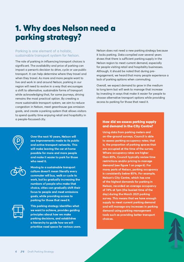
1. Purpose
of Report
1.1 To consider and approve
the Draft Parking Strategy and Draft Parking Management Plans for community
engagement and public feedback.
2. Summary
2.1 Following
pre-engagement with stakeholders and workshops with elected members a Draft
Parking strategy (Strategy) has been developed. These documents will serve as
the 10-year framework for guiding parking in Nelson.
2.2 The Strategy document
covers why Council needs to manage parking, what the drivers for change are,
and what parking challenges Nelson is facing. It contains objectives and
principles that will guide Council decision making about parking and
reallocating road space.
2.3 Based
on the Strategy, Parking Management Plans (PMPs) have been developed for the
Central City/fringe, Tahunanui and Stoke and provide a guide on how parking
resources will be managed in areas and key locations that experience high
parking demands.
2.4 The
Strategy and PMPs are presented to the Committee for approval to proceed with
wider community engagement.
3. Recommendation
|
That
the Infrastructure Committee
1. Receives
the report Draft Parking Strategy - Approval to seek public feedback (R26375) and its attachments (A2862519,
A2838508, A2838509, A2838510 and A2844394); and
2. Agrees to seek public feedback on
the Draft Parking Strategy (A2862519) and the Draft Parking Management Plans
(A2838508, A2838509 and A2838510); and
3. Agrees that the Draft Parking
Strategy engagement process and public feedback opportunities meet the
requirements of the Local Government Act 2002 including the principles of
consultation in section 82; and
4. Approves the Draft Parking Strategy
(A2862519) and Draft Parking Management Plans (A2838508, A2838509 and
A2838510) for public feedback; and
5. Delegates to the Chair, Deputy
Chair and Chief Executive to approve any minor amendments required to the
supporting information or public feedback materials prior to the start of the
consultation process; and
6. Approves the consultation approach
set out in section 8 (attachment A2844394) of this report (R26375); and
7. Notes the approach includes
sufficient steps to ensure the Draft Parking Strategy and proposed Parking
Management Plans will be reasonably accessible to the public and will be
publicised in a manner appropriate to its purpose and significance.
|
4. Background
4.1 The purpose of the
Strategy is to provide a framework for Council to make consistent and
transparent decisions for managing on-street and off-street parking, and to
prioritise road space. The Strategy establishes objectives and principles to
guide changes to Council-controlled parking in Nelson. The full strategy is
appended as Attachment 1.
4.2 The Strategy contributes
to Councils Long Term Plan (LTP) goal of “developing a sustainable
transport system as a key triennium focus for the next three years.”
It aligns with the overall vision for Councils Regional Land Transport Plan
(RLTP) for a safe and connected region that is liveable, accessible, and
sustainable.
4.3 The
Strategy is consistent with Council’s endorsement of the Nelson Future
Access Detailed Business Case and contributes to NCC’s climate change
goals by aligning the future transport system towards a low-carbon multi-modal
future with less dependence on single occupancy car movements.
4.4 The
PMPs provide a further guide on how parking resources are proposed to be
managed in larger centres and other key locations that experience high parking
demands.
4.5 The Strategy and PMPs are
high level, non-statutory policy documents that do not impose any directly
enforceable requirements in relation to parking. Current parking
requirements are in Council’s Parking and Vehicle Control Bylaw.
Any changes to the current parking requirements would require a change to the
Bylaw, including any changes proposed to implement a finalised Parking
Strategy. Any proposed changes to the Bylaw would follow the statutory
process which includes consultation through the Special Consultative Procedure.
4.6 The
Strategy has not been developed in isolation and has been developed in close
consideration of other Council strategies, including:
4.6.1 Whakamahere Whakatū Nelson Plan
(in development);
4.6.2 2022
Future Development Strategy (in development);
4.6.3 Public
Transport network plans;
4.6.4 Te
Ara ō Whakatū – Nelson City Centre Spatial Plan (since been
adopted by Council on 8 December 2020)
5. Engagement
5.1 Parking
Strategy city centre engagement was carried out alongside engagement for Te Ara ō Whakatū – Nelson City Centre
Spatial Plan. Overall, for the city centre, 81 meetings have been held with
over 250 attendees from over 40 community sectors. Meetings were kept
intentionally small to enable voices to be heard. Parking was a strong theme.
5.2 In preparing the Strategy
and PMP’s for the City Centre, Stoke and
Tahunanui the following work has been carried out:
· 2 dedicated
meetings/presentations with NMIT and key stakeholders alongside those held for
Te Ara ō Whakatū- Nelson City Centre Spatial Plan.
· Meetings with Stoke and
Tahunanui businesses and public drop in sessions;
· Shape Nelson page
inviting comment and suggestions;
· Demand forecasting;
· Workshops with elected
members;
· Parking surveys
5.3 Engagement
with Stoke and Tahunanui communities was delayed due to COVID19 alert levels.
However, since September 2021 public drop-in sessions have been held and over
80 face to face discussions occurred.
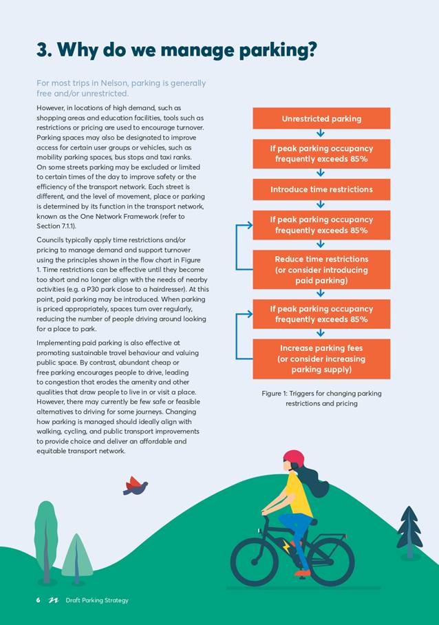
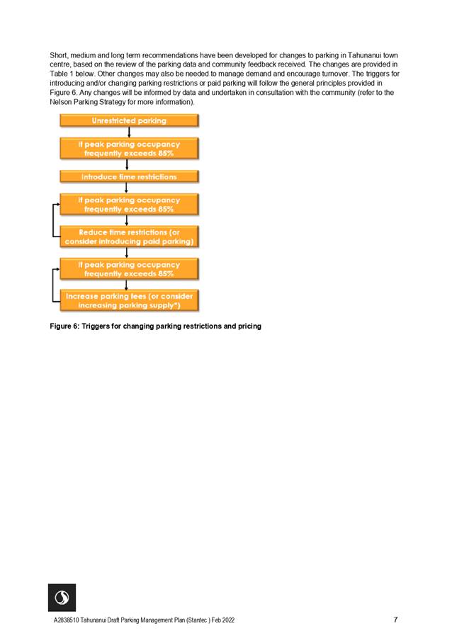
6. Discussion
Challenges
6.1 The
Strategy has been written recognising a number of key challenges that will
influence how parking is managed in Nelson including limited alternative
transport options, current relative costs of travelling by bus vs private
vehicle, competition with Richmond, and the overall current rates of car
dependency.
6.2 Parking
management can be both divisive and personal and needs to balance community
expectations for cheap or free parking close to destinations and access needs
of multiple users.
Objectives
6.3 The
proposed objectives for managing parking outline what Council is seeking to
achieve, align with Council’s vision for the city and will guide Council
when making decisions about parking. There are unavoidable conflicts between
these objectives, and trade-offs will need to be made to balance competing
demands.
6.4 The
proposed objectives for managing parking in Nelson are as follows:
• Supports mode shift;
• Supports a
people-focused city;
• Supports inclusive
access;
• Supports economic
development;
• Supports a safe
and efficient transport system; and
• Is valued and
managed efficiently
Principles
6.5 The
guiding Principles of the Strategy, which explain how Council will apply the
objectives to make decisions about parking and reallocating road space are:
· Street space is
prioritised to deliver safety and mode shift outcomes;
· Parking is valued
and managed equitably;
· Parking is used
efficiently;
· Road users who
benefit from parking contribute to the cost of parking provision;
· Parking availability
information is accessible;
· Staged
implementation of parking management to align with walking, cycling and public
transport improvements; and
· Changes to parking
are guided by policy and triggered by data
Parking
Management Framework
6.6 In
order to achieve the proposed objectives, a framework (based on best practice)
has been formulated that has guided the development of the PMP’s. This
framework, referred to in the draft Strategy as the Parking Road Map, includes:
· How space on our
streets is prioritised - balancing movement and place;
· Measuring progress
and triggers for change;
· Parking management
tools;
- Reserved
Parking
- Time
restrictions and Paid Parking
- Permits
- Park
and Ride
- Managing
Parking in Parks and Reserves
- Enforcement
and Revenue
- Technology
7. Parking
Management Plans
7.1 The
PMPs provide a guide on how parking resources will be managed in larger centres
and other key locations that experience high parking demands.
7.2 A
PMP outlines the existing parking supply and demands in the area and provides
an overview of the existing transport network and land use. A PMP also
highlights how any proposed changes might influence parking demand or supply in
the future. Based on this evidence, PMPs include short, medium and long-term
recommendations for improving how parking is managed.
7.3 PMP’s
have been developed for the Central City (including the fringe), Stoke and
Tahunanui and are discussed in detailed below.
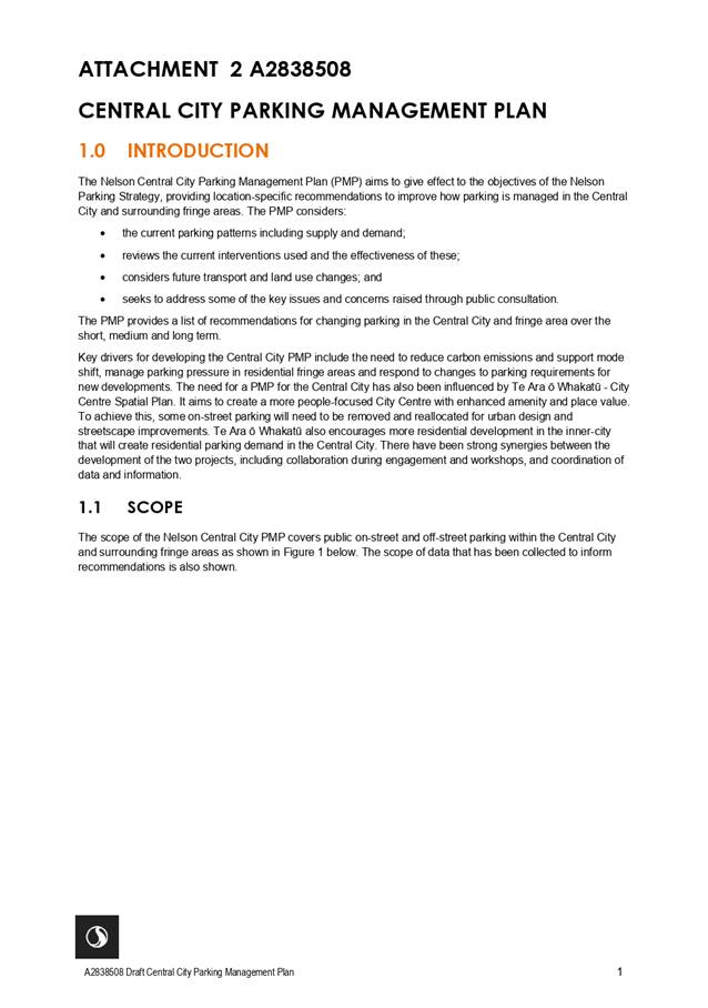
Central City
and fringe PMP
7.4 One
of the key influences in developing a PMP for the Central City is the
development of the Central City Spatial Plan - Te Ara ō Whakatū. This
was adopted by Council on 8 December 2021 and aims to create a more people-focused
City Centre with enhanced amenity and place value. To achieve this, some
on-street parking will need to be removed and reallocated for urban design and
streetscape improvements. Te Ara ō Whakatū also seeks to provide more
residential development in the inner-city that will create residential parking
demand in the Central City. There have been strong synergies between the
development of the two projects, including collaboration during engagement and
workshops, and coordination of data and information.
7.5 It is recommended that
there is no net gain in parking provision in the Central City and fringe areas.
This recommendation is based on the objectives within the Parking Strategy and
the observations of current levels of parking activity. Recorded occupancy data
shows there is sufficient supply within Central City to manage short and
medium-term parking demands to provide for visitors and shoppers to the
commercial area. Parking controls and travel demand management are recommended
tools to manage parking efficiently and equitably and encourage mode shift if
City Centre changes result in a potential reduction in parking.
7.6 The
data highlights there is already strong demand for long term parking on the
fringe. Residential intensification in the Central City and fringe areas,
combined with removal of minimum parking requirements, will continue to
increase pressure for on-street parking. However, continually increasing
parking supply to meeting growing demand erodes the liveability and vibrancy of
the Central City and fringe areas and encourages people to drive.
7.7 Short,
medium and long-term recommendations have been developed for changes to parking
in the Central City and fringe area based on the review of the parking data and
community feedback received. Triggers for several recommendations have been
identified to align with other major improvements or changes such as the
implementation of major changes to bus services, scheduled for 2023. The
proposed recommendations for changes to parking in the Central City and fringe
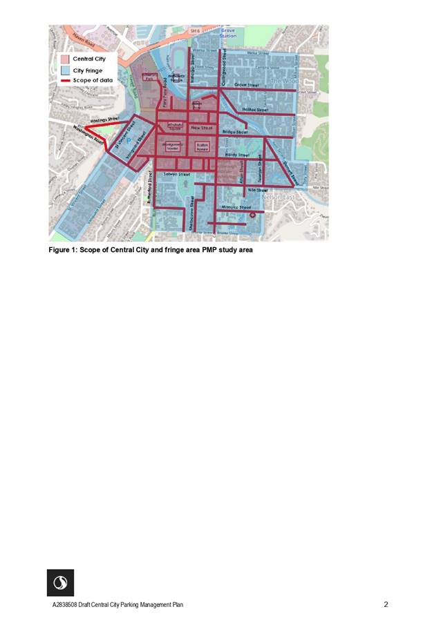
area are summarised below and outlined in full in attachment 2.
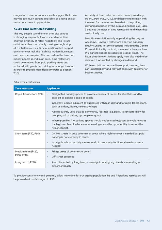
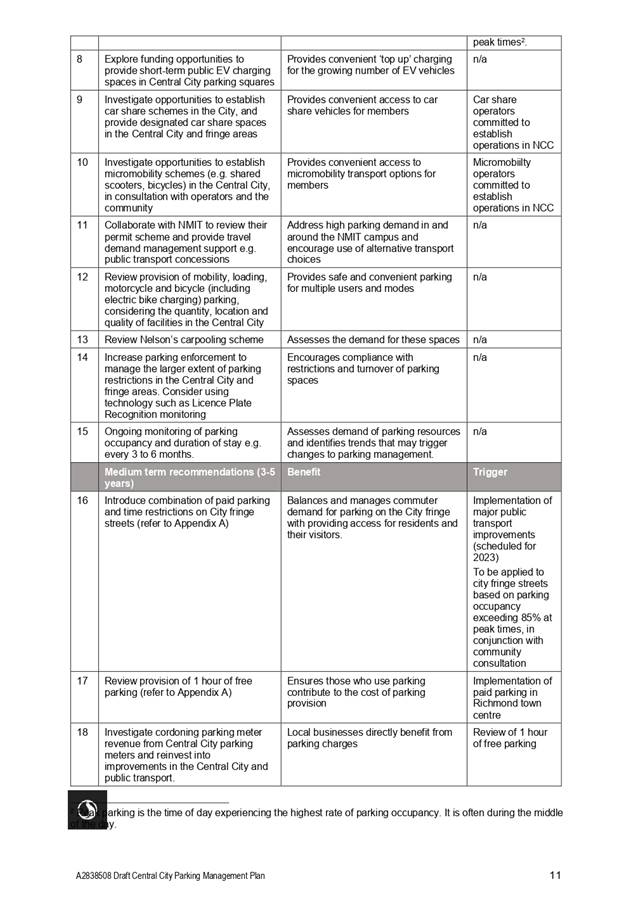
7.7.1 Short
term (1-2 years)
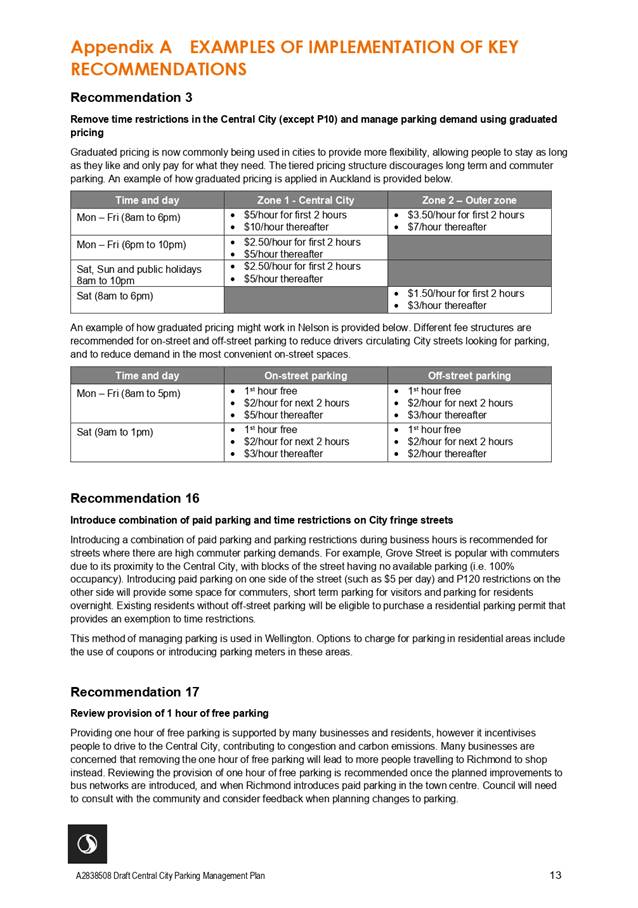
· Remove time restrictions
in the Central City (except P10) and manage parking demand using graduated
pricing;
· Review parking fees in the
Central City, ensuring off-street parking in the Central City is cheaper than
on-street parking;
· Increase the use of more
flexible parking restrictions to allow for multiple or shared use based on time
of day/week (e.g. P10 during business hours only, AM peak loading zones, shared
bus stops, and taxi zones based on time of day);
· Develop and implement
new residential parking scheme including removing dedicated residential parking
bays, increasing cost of permits and changes to eligibility and parking
exemptions;
· Introduce or change
pricing or restrictions as peak parking occupancy thresholds are reached;
· Explore funding
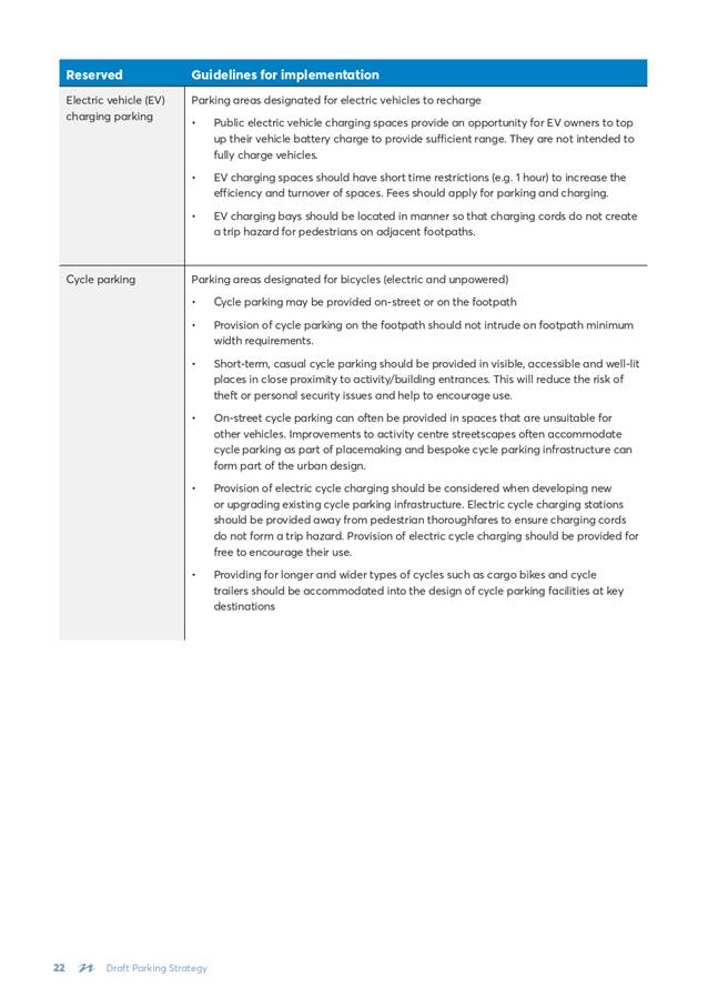
opportunities to provide short-term public EV charging spaces in Central City
parking squares;
· Investigate
opportunities to establish car share schemes in the City, and provide
designated car share spaces in the Central City and fringe areas;
· Investigate
opportunities to establish micro-mobility schemes (e.g. shared scooters,
bicycles) in the Central City, in consultation with operators and the
community;
· Collaborate with NMIT to
review their permit scheme and provide travel demand management support such as
enhanced bus concessions;
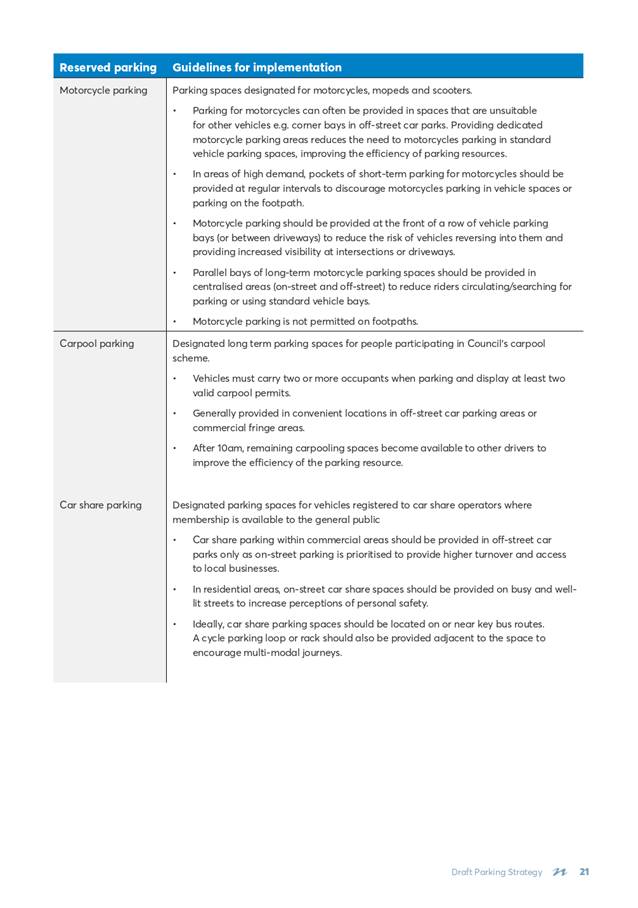
· Review provision of
mobility, loading, motorcycle and bicycle (including electric bike charging)
parking, considering the quantity, location and quality of facilities in the
Central City;
· Review Nelson’s
carpooling scheme;
· Increase parking
enforcement to manage the larger extent of parking restrictions in the Central
City and fringe areas. Consider using technology such as Licence Plate
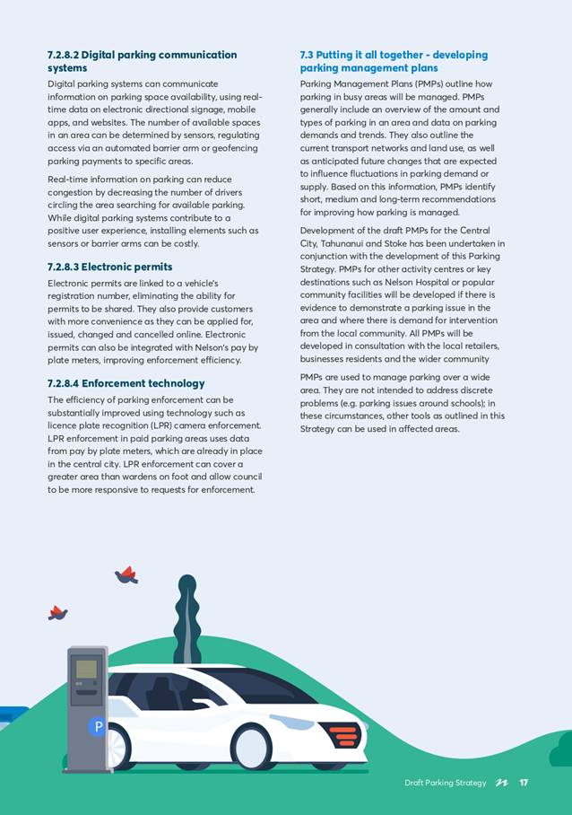
Recognition monitoring; and
· Ongoing monitoring of
parking occupancy and duration of stay e.g. every 3 to 6 months
7.7.2
Medium term (3-5 years)
· Introduce combination of
paid parking and time restrictions on City fringe streets
· Review provision of 1
hour of free parking;
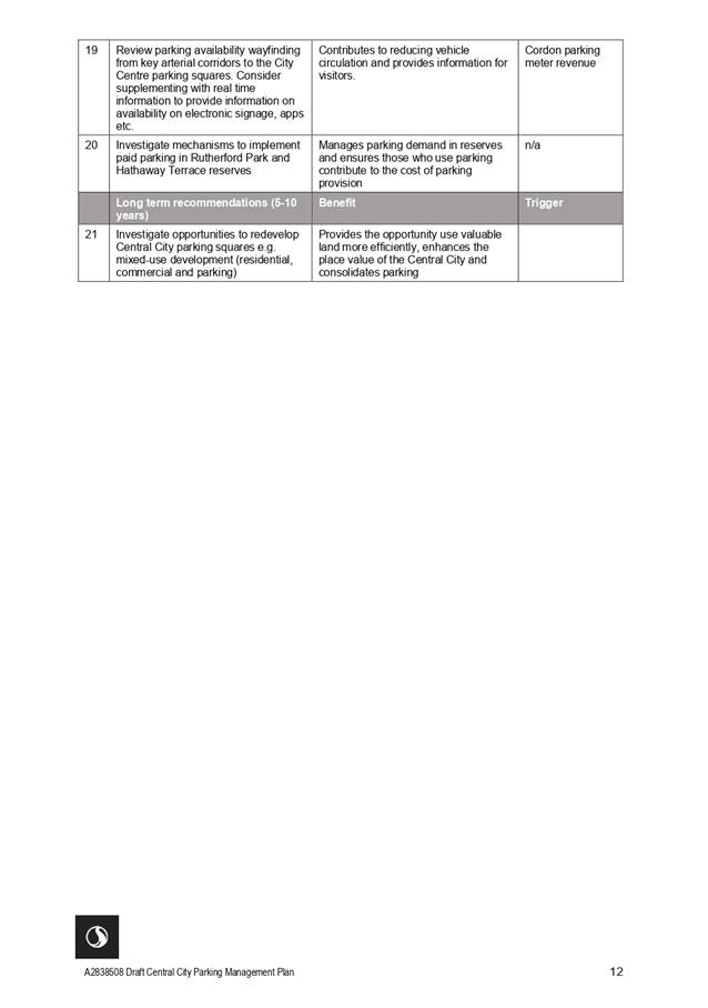
· Investigate further
cordoning parking meter revenue from Central City parking meters and reinvest
into improvements in the Central City and public transport;
· Review parking
availability wayfinding information from key arterial corridors to the City
Centre parking squares. Consider supplementing with real time information to
provide information on availability on electronic signage, apps etc; and
· Investigate mechanisms
to implement time restrictions and/or paid parking in Rutherford Park and
Hathaway Terrace reserves
7.7.3 Long
term (5-10 years)
· Investigate
opportunities to redevelop Central City parking squares e.g. mixed-use
development (residential, commercial and parking)
Stoke PMP
7.8 Based on the objectives
within the Strategy and the level of parking activity in Stoke, it is
recommended that no additional public parking spaces are provided in Stoke.
While there is forecast growth in the surrounding area, increasing parking
supply to meeting growing demand further erodes the vibrancy of a town centre
and encourages people to drive. Using parking management as well as travel
demand management tools to optimise existing parking supply will ensure public
parking resources are managed efficiently and equitably and encourage use of
sustainable transport modes.
7.9 Short,
medium and long-term recommendations have been developed for changes to parking
in Stoke town centre, based on the review of the parking data and community
feedback received. The proposed recommendations for changes are summarised
below provided in attachment 3
· Specific recommendations
for changes to parking and access in Strawbridge Square.
· Reduce existing P180
restrictions to P120
· Replace all P5 and P15
spaces with P10
· Increase taxi/PSV
parking in Strawbridge square near New World
· Introduce EV charging
spaces in Strawbridge Square and Greenmeadows community centre car parks
· Introduce motorcycle
parking bay in Strawbridge Square
· Review the need for
additional loading zones (e.g. within Strawbridge Square)
· Upgrade Strawbridge
Square to improve amenity and enhance pedestrian access across entrances
· Review access
arrangements to Strawbridge Square and consider implementing turn bans to
reduce queuing within the car park.
· Improve
signage/linemarking on one-way accesses to Strawbridge Square
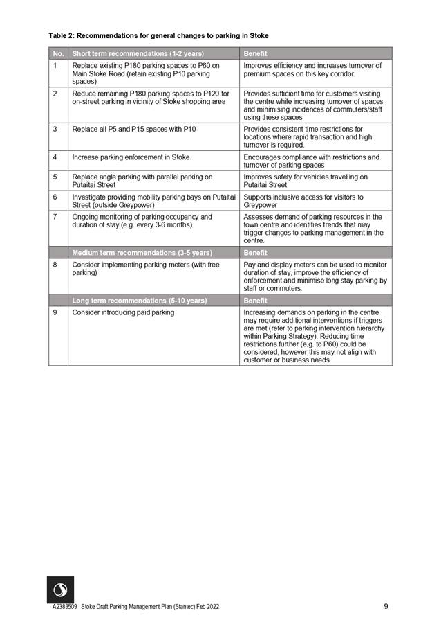
7.9.1 Stoke
short term (1-2 years)
· Replace existing P180
parking spaces with P60 on Main Stoke Road (retain existing P10 parking spaces)
· Reduce remaining P180
parking spaces to P120 for on-street and off-street parking in vicinity of
Stoke shopping area
· Replace all P5 and P15
spaces with P10
· Increase parking
enforcement in Stoke
· Replace angle parking
with parallel parking on Putaitai Street
· Investigate providing
mobility parking bays on Putaitai Street (outside Greypower)
· Ongoing monitoring of
parking occupancy and duration of stay (e.g. every six months)
7.9.2 Stoke
midterm (3-5 years)
· Consider
implementing parking meters (with free parking)
7.9.4
Stoke Long term (5-10 years)
· Consider introducing
paid parking
Tahunanui PMP
7.10 Based
on the objectives within the Parking Strategy and the level of parking activity
in Tahunanui, it is recommended that no additional public parking spaces are
provided in Tahunanui.
7.11 Short,
medium and long-term recommendations have been developed for changes to parking
in Tahunanui, based on the review of the parking data and community feedback
received. The proposed recommendations for changes are summarised below
provided in attachment 4.
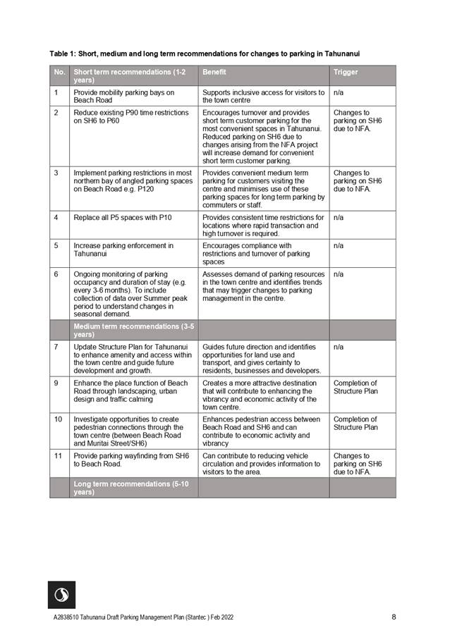
7.11.1 Tahunanui
short term (1-2 years)
· Provide mobility parking
bays on Beach Road
· Reduce existing P90 time
restrictions to P60 on State Highway 6
· Implement P120 parking
restrictions in most northern bay of angled parking spaces on Beach Road
· Replace all P5 spaces
with P10
· Increase parking
enforcement in Tahunanui
· Ongoing monitoring of
parking occupancy and duration of stay (e.g. every six months). To include
collection of data over summer peak period to understand changes in seasonal
demand
7.11.2
Tahunanui Medium term (2-3 years)
· Update Structure Plan
for Tahunanui to enhance amenity and access within the town centre and guide
future development and growth
· Enhance the place
function of Beach Road through landscaping, urban design and traffic calming
· Investigate
opportunities to create pedestrian connections through the town centre (between
Beach Road and Muritai Street/SH6)
· Provide parking
wayfinding from SH6 to Beach Road
7.11.3 Tahunanui Long Term (5-10
years)
· Implement time
restrictions for other streets within the town centre
· Implement parking meters
(to control length of stay - with free parking)
· Introduce paid parking
7.12 Waka
Kotahi plan to reintroduce southbound lanes later this year on State Highway 6
in Tahunanui. Whilst this work by Waka Kotahi is not part of the draft Parking
Strategy, separate to the Strategy officers are preparing a business case that
will consider off-street parking for the businesses and will be bringing a
report back to Council once completed.
8. Community
Engagement Approach
8.1 While
there is may be high levels of public interest in some changes to parking
requirements, it is considered that the decision to adopt a Strategy and the
PMPs is of low to moderate significance when assessed under Council’s
Significance and Engagement Policy. For example, these high level policy
documents do not impact of levels of service, Council’s debt or the level
of rates. Any decisions to change parking requirements themselves will be
subject to future decision-making processes, for example amendment of the
Parking and Vehicle Control Bylaw or LTP or Hearing Panel-Other processes and
consultation at that time as required.
8.2 Given
that the draft Strategy and PMPs includes outcomes that will be of interest to
the community, officers recommend a consultation process consistent with the
principles of section 82 of the Local Government Act 2002 (LGA02). This
will enable Council to be informed of the views of the community and those
affected in deciding to adopt, or not adopt, the Parking Strategy and
PMPs.
8.3 It
is proposed that a formal public consultation process will commence on 11 April
2022. The public will be encouraged to provide feedback on the Draft Strategy
and PMPs with online or physical options including via Shape Nelson, email,
phone or hardcopy public feedback form. This public consultation period will
close on 16 May 2022 (5 weeks total duration).
8.4 A full list of
organisations who will be directly contacted and invited to comment on the
draft is appended as Attachment 5. In summary during the 5-week feedback period
Council will seek to engage through a range of means including:
· Local media
· Direct engagement with
interest groups and key stakeholders. Newsletter updates
and direct information will be sent to those listed in the engagement
plan
· Our Nelson – early
April publication date – Draft Parking Strategy and plans (distribution
20,000)
· Shape Nelson –
NCC’s consultation page will reflect the consultation document
· Social media –
event scheduling and social media posts using created content
· Iwi partners have been
made aware of the Strategy development through a Te Ohu Taiao (Environment)
meeting that was held in May 2021
· Note: Face to face
events will be dependent on COVID-19 setting.
8.5 Officers
will summarise the feedback received and report this to this Committee with
recommendations incorporated into the final document.
8.6 The updated Parking
Strategy will then be presented at a Council meeting later in the year to seek
approval for final adoption.
9. Options
9.1 The
Committee can either approve, amend, or not approve the Draft Parking Strategy
document and draft PMPs for public feedback and community engagement.
Substantive changes may require an amendment to the timeline for feedback and
final adoption. Officers recommend Option 1.
|
Option 1: Approve the Draft
Parking Strategy and draft PMPs for public feedback and community engagement (Recommended Option)
|
|
Advantages
|
· Enables
Council to obtain and consider the views of the wider community, to inform
whether any changes should be made to the Draft Parking Strategy and
PMP’s documents before it is finalised.
· Consistent
with LTP.
· While
a formal special consultation process is not required, seeking engagement in
this way enables Council to fulfil the community engagement requirements of
the Local Government Act 2002.
|
|
Risks and Disadvantages
|
·
None
|
|
Option
2: Amend the Draft Parking Strategy and draft PMPs prior to public feedback
and community engagement
|
|
Advantages
|
· If
Committee considers the document and public feedback / engagement approach
does not meet its needs or the needs of the community, Council can direct
changes ahead of consultation.
|
|
Risks and Disadvantages
|
· Amendments
to the document may not reflect the engagement undertaken to date.
· Delays
to timeframe to progress Draft Parking Strategy community engagement.
|
|
Option
3: Do not approve the Draft Parking Strategy and draft PMPs for public
engagement
|
|
Advantages
|
· No
identifiable advantage.
|
|
Risks and Disadvantages
|
· Reputational
damage that Council does not promote Smart Little City aspirations.
· Cost
in developing the Draft Parking Strategy will be sunk.
|
10. Conclusion
10.1 Officers recommend that the Draft
Parking Strategy and draft PMP documents be approved for release for public
feedback.
11. Next Steps
11.1 If
the Committee agrees to the proposed approach the next steps would be:
11.1.1 To
commence engagement in accordance with the Community Engagement Approach
outlined in section 8 from 11 April 2022 to the 16 May 2022.
11.1.2 To
collate responses and prepare report back to the 4 August 2022 Infrastructure
committee.
11.1.3 To
update the draft Parking Strategy and PMP’s and to present them at the 25
August 2022 Council meeting to seek approval for adoption.
11.1.4 As
changes recommended under the PMPs are phased in further consultation will
occur through the LTP, Parking Bylaw or Hearings Panel (Other) as appropriate.
Author: Margaret
Parfitt, Manager - Transport and Solid Waste
Attachments
Attachment 1: A2862519
Draft Parking Strategy March 2022 ⇩
Attachment 2: A2838508
- Draft Central City and Fringe Parking Management Plan ⇩
Attachment 3: A2838509
- Draft Stoke Parking Management Plan ⇩
Attachment 4: A2838510
- Draft Tahunanui Parking Management Plan ⇩
Attachment 5: A2844394
- Communications and Engagement Plan ⇩
|
Important considerations for decision making
|
|
1. Fit
with Purpose of Local Government
Approving a Draft Strategy for release for community
feedback promotes democratic local decision-making. Decisions in this report
allow Council to consult the community on whether to adopt the future Parking
Strategy. This will allow Council to make decisions on behalf of the
community to promote its social, environmental, and economic, well-being that
are consistent with the purpose of the Local Government Act.
|
|
2. Consistency
with Community Outcomes and Council Policy
The Draft Parking Strategy is consistent with
Nelson’s urban development strategies. It aligns with
Council’s Long-Term Plan, the Draft Whakamahere Whakatū Nelson
Plan, Future Development Strategy, key Transport Strategies, including Nelson
Future Access Strategy (Waka Kotahi), modal shift (walk and cycle), bus
public transport and Te Ara ō Whakatū- Nelson City Centre Spatial
Plan
|
|
3. Risk
The approval of a draft for wider community feedback
carries a low risk.
|
|
4. Financial
impact
No additional funding is sought in this report.
|
|
5. Degree
of significance and level of engagement
While a high level of public interest exists for
parking the Draft parking Strategy is considered of low to moderate
significance when considered against criteria in Council’s Significance
and Engagement Policy. It will not require a Special Consultative
Process (SCP) as it will not impact on levels of service provided by Council,
degree of impact on Council’s debt or the level of rates it charges,
and that decisions related to the Draft Parking Strategy are not
irreversible.
Given the Strategy includes outcomes that will be of
interest to the community, officers have recommended engagement to invite
feedback (as outlined I section 5.18 of this report) prior to bringing a
final version to Committee for recommendation to Council for adoption.
Public feedback will be
sought on the Draft Parking Strategy and proposed PMP’s during a 5-week
period (11 April – 16 May 2022).
|
|
6. Climate
Impact
The strategic vision of the Draft Parking Strategy
acknowledges climate change is a risk facing the city and region. The Draft
Parking Strategy promoted modal shift and lower carbon emissions.
|
|
7. Inclusion
of Māori in the decision-making process
No engagement with Māori has been undertaken in
preparing this report
|
|
8. Delegations
The Infrastructure Committee has the following
delegations to consider approving a Draft Parking Strategy and Parking
Management Plans (noting that the approval of the final version of the
Strategy will be in the form of a recommendation from the Committee to
Council):
Areas of Responsibility:
Transport network, including, roading network and
associated structures, walkways, cycleways and shared pathways, footpaths and
road reserve, street lighting, traffic management control and parking.
Delegations:
Developing, approving, monitoring, and reviewing
policies and plans, including activity management plans and the
Infrastructure Strategy.
· Developing,
monitoring, and reviewing strategies, policies, and plans, with final
versions to be recommended to Council for approval
· Undertaking
community engagement, including all steps relating to Special Consultative
Procedures or other formal consultation processes, other than final approval
|
Item
7: Draft Parking Strategy - Approval to seek public feedback: Attachment 1 A2862519


Item 7: Draft Parking Strategy -
Approval to seek public feedback: Attachment 2
Item 7: Draft Parking Strategy -
Approval to seek public feedback: Attachment 3
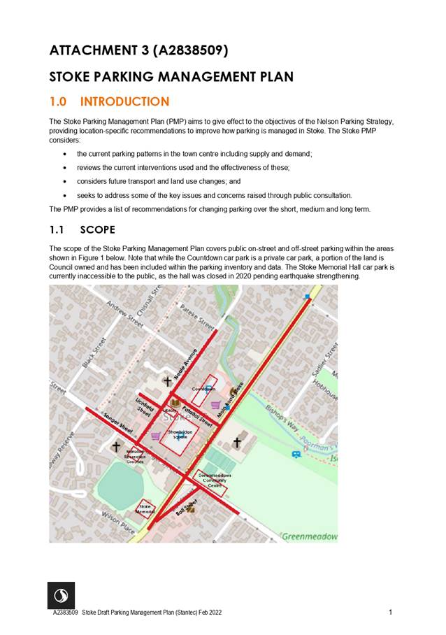
Item 7: Draft Parking Strategy -
Approval to seek public feedback: Attachment 4

Item 7: Draft Parking Strategy -
Approval to seek public feedback: Attachment 4
Item 8: Pride Crossing
- Way Forward
|

|
Infrastructure Committee
31 March 2022
|
REPORT R26253
Pride
Crossing - Way Forward
1. Purpose
of Report
1.1 To
present feedback to the Committee following targeted engagement, and for the
Committee to consider options and decide on either a pride crossing location or
an alternative form and location.
2. Summary
2.1 The
25 February 2021 Infrastructure Committee considered installing a pride
crossing on the Bank Lane central Trafalgar Street raised courtesy crossing as
a permanent feature.
2.2 The
Committee resolved to consider a pride crossing not at that specific location,
but at a location somewhere in the central city on a raised courtesy crossing.
2.3 Additional
engagement on a location in the central city has been undertaken by the Deputy
Mayor and the Chair of the City Centre Engagement Group as well as officers to
guide a preferred location and a way forward – the subject of this
report.
3. Recommendation
|
That the Infrastructure Committee
1. Receives the report Pride Crossing
- Way Forward (R26253) and its attachments (A2749080, A2773987, A2829334 and
A2829335); and
2. Approves either:
a) a pride crossing, as a permanent feature,
on the Central Trafalgar Street courtesy crossing (opposite Bank Lane) at an
estimated cost of $15,000;
OR
b) Revokes Resolution IC/2021/001 of the Infrastructure
Committee meeting held on 25 February 2021:
“Approves
the installation of a Progress Pride design on a central city raised courtesy
crossing as a permanent feature”; then
3. Approves the installation of a
pride decal on either the Trafalgar Street bike rack and/or Montgomery Square
bike rack at an estimated cost of $4,000 or $8,000
respectively.
|
4. Background
4.1 The
Chair of the Infrastructure Committee as part of his Chairs Report to the 25
February 2021 Committee supported the idea, suggested by his Deputy Chair, to
install a pride crossing on the central courtesy crossing in Trafalgar Street
(opposite Bank Lane). The extract from that report is appended as Attachment 1
(A2749080).
4.2 The
Committee however agreed that further city centre engagement was required
before any works proceeded and resolved as follows:
Resolution IC/2021/002
“Approves the
installation of a Progress Pride design on a central city raised courtesy
crossing as a permanent feature”.
4.3 The
Deputy Mayor and the Chair of the City Centre Engagement
Group have engaged with a core group of stakeholders and have proposed an
alternative location for the pride crossing. That engagement included several
walking tours through the central city and consideration of several locations
with the following groups – Police, Q Youth, Lesbian Link, Nelson Pride,
Blind Low Vision Citizens, Youth Council, Arts Nelson, and Uniquely Nelson.
4.4 The
Committee resolution is very clear – that a pride crossing will be
installed on a raised courtesy crossing in the central city as a permanent
feature.
5. Discussion
Original
suggested location – Across Trafalgar Street opposite Bank Lane
5.1 The
cost, as reported to the 25 February 2021 Infrastructure Committee, to install
a pride crossing on the central pedestrian courtesy crossing in Trafalgar
Street was estimated at between $5,000 and $9,000.
5.2 Whilst
that was an estimate at the time, as a result of COVID-19, leading to an
increase in costs of materials as well as the high inflation environment, the
cost of the crossing in Bank Lane is now estimated to be $15,000.
5.3 For
information, the paint to be applied to create a pride crossing (irrespective
of its location) is a specialised product – a cold pressed plastic
(component resin) - that will have high skid and high slip resistance
qualities.
5.4 The
cost to install a pride crossing depends on the extent of the work required as
well as the extent of temporary traffic management required to undertake the
works. The more heavily trafficked the area the greater the traffic management
required to facilitate installation and hence the greater the cost. Undertaking
the work in the warmer months is essential.
Base assumptions for a pride
crossing
5.5 A
pride crossing is deemed road art. The Land Transport Rule: Traffic Control
Devices (2204) notes that roadway art must be installed in a way that is
compliant with the Rule if the art:
a. is
installed in a lower risk environment; and
b. does
not resemble and is not similar to a marking described in this Rule; and
c. does
not mislead road users about the meaning of any traffic control device; and
d. is not
part of or visually integrated into a marking specified in Schedule 2.
5.6 What
this means, in layman’s terms, is that artwork may be installed on a
roadway in New Zealand if it is installed in a lower risk environment
(demonstrable vehicle operating speeds of 30km/h or less – not just
signposted after the art and any other features have been installed) and cannot
be on a zebra crossing.
5.7 With
respect to lower risk environments, this excludes intersections such as the
Trafalgar/Halifax intersection where the operating speed is above 30km/h. Waka
Kotahi has also signalled that it will not support or approve any road art in
an environment that has an operating speed greater than 30km/h.
External Funding
5.8 An
amount of $2,000 was raised through the “Give a Little” fund and
this has been handed over to Council by the organiser. Should the pride
crossing not go ahead, this money would need to be returned to the fund so that
donated money can go back to the original donors.
5.9 In
addition to this, an amount of $5,000 offered by the Youth Council towards this
project last financial year has been carried over into the current financial
year.
6. Other
locations considered
6.1 Halifax/Trafalgar
intersection. This location has been suggested by one of the groups engaged
with. Officers have priced this at an estimated $50,000, but it is nonetheless
deemed unsuitable as the location does not adhere to a 30km/h operating speed
and is not supported by Waka Kotahi. This location is not considered further in
this report.
6.2 The
six alternative locations (refer attachment 2, A2773987), considered for a
pride crossing include the following (none included any existing zebra
crossings):
6.2.1 Either
of the crossings in Trafalgar Street off Bridge Street;
6.2.2 Crossing
in Trafalgar Street off Hardy Street;
6.2.3 Trafalgar
Street crossing New Street/Achilles Avenue walkway;
6.2.4 Trafalgar
Street crossing at Hardy Street end of pedestrian mall;
6.2.5 Trafalgar
Street Bank Lane; and
6.2.6 Selwyn
Street at Upper Trafalgar Street.
6.3 Whilst
there was no unanimous support for a pride crossing, the preferred location,
following engagement by the Deputy Mayor and Chair of the City Centre
Engagement Group, is at the top end of Trafalgar Street across Selwyn Place
between the two existing zebra crossings (refer to Attachment 3, A2829334). It
was noted by those who supported this location that engagement would need to
take place with both iwi and the Anglican Diocese.
6.4 Officers
have major reservations concerning this layout and provide commentary on this
later in the report.
7. Concurrent
work in Selwyn Place/top of Trafalgar Street
7.1 Before
offering specific commentary on the location of a pride crossing, officers for
completeness, bring to the attention of the committee planned works along
Selwyn Place that have the potential to influence any pride crossing work in
that area.
7.2 As
part of the inner-city speed reduction to 30km/h, Council resolved to reduce
the speed on Selwyn Street to 30km/h. As noted previously merely signposting a
street to 30km/h, in itself, is not adequate as the environment needs to be
changed to ensure that the 85th percentile operating speed is in
fact 30km/h or less.
7.3 The work proposed for
Selwyn Place to effect traffic calming intervention measures to give effect to
the Council resolution, includes a new raised pedestrian crossing in the
vicinity of Fashion Island, raising the two existing zebra crossings either
side of the Cawthron Steps and lane narrowing’s in the vicinity of
McDonald’s. This work is due to be completed by the end of the calendar
year, with budget allowance of $150,000. Heavy surface maintenance on Selwyn
Place will be carried out in March/April 2022.
8. Officer
commentary
8.1 Of
the six alternative locations considered (excluding the Halifax/Trafalgar
Street location):
8.1.1 The
Selwyn Place proposal as presented, is not supported by officers and that is
discussed in more detail later in the report. A variation to what is proposed
is offered by officers.
8.1.2 The
other locations in Trafalgar Street are options. The costs to install a pride
crossing on any of these crossings are similar in cost to the Bank Lane
costs.
8.2 No
single location, with the groups engaged, received unanimous support. For
example, the Blind Low Vision Citizens Group did support the Selwyn Street
location if the existing crossing points remained, whilst Police supported the
Bank Lane crossing and others were not in support of the New Street/Achilles
crossing.
Selwyn Place/Upper Trafalgar
Street proposal
8.3 This
location includes installing a pride crossing between the two existing zebra
crossings. Whilst this location does not breach the View Shaft rule in the
District Plan, it does raise serious health and safety (H&S) concerns for
officers.
8.4 The
pride crossing in this location and format would be deemed road art and cannot
be either a formal zebra crossing or a courtesy crossing.
8.5 The
main concern with respect to H&S is that having a colourful feature between
two legal zebra crossings will be potentially very confusing and dangerous for
pedestrians and other users especially as they walk up Trafalgar Street towards
the steps. Users may not differentiate that the road art is not a crossing
point and could be placing themselves in harm’s way by crossing the road
at this point heedless of oncoming traffic. The result of an error by a
pedestrian could result in serious injury or death.
9. Officer
alternative proposal
9.1 Officers,
in keeping with the view that Selwyn Place is a potential location have come up
with an alternative layout (refer to attachment 4, A2829335). This proposal
involves removing the two existing zebra crossings and replacing those with a
single raised zebra crossing (that would also aid slowing traffic speeds down
to achieve the 30km/h lower speed environment) in the centre of Trafalgar
Street opposite the Cawthron steps, with an at-grade pride area leading into
the zebra crossing from Trafalgar Street.
9.2 As
noted earlier, budget already exists to undertake works in Selwyn Street
including raising the two existing zebra crossings. Replacing these with a
central raised zebra crossing can be catered for in the existing budget.
9.3 The
estimated additional cost of incorporating the pride area into the new crossing
would be in the order of $13,000.
Engagement on alternative
option – Upper Trafalgar/Selwyn
9.4 Officers
have engaged further with the groups previously engaged with by the Deputy
Mayor and Chair of the City Centre Engagement Group, as well as with iwi,
Nelson Tasman Chamber of Commerce, and the Anglican Diocese on this alternative
option. Feedback is as follows:
9.4.1 Iwi
– Supportive of a pride crossing but not in support of a Selwyn location
due to the significance of piki mai.
9.4.2 Anglican
Archdiocese – note that whatever is undertaken needs to complement the Cathedral,
the steps and piki mai as these are important visual features and are unique to
Trafalgar Street; that any pride crossing in this area should it go ahead would
need regular maintenance to ensure that it remains fresh; and finally, that the
Upper Trafalgar Street Plaza seems to be becoming congested with all the recent
work compared to other parts of the city.
9.4.3 Chamber
of Commerce – No fixed position on any location but do support any new
investment initiatives that support the inner city.
9.4.4 Police
– Whilst would support the alternative, prefer Bank Lane.
9.4.5 Q
Youth – Not in support of this location.
9.4.6 Lesbian
Link – No problem with the proposal.
9.4.7 Nelson
Pride – Not supportive of crossing in this location and have suggested
other locations at Founders or Tahunanui; note that they are less concerned
about the location than they are about ensuring that the visible support of
flags and crossings be supported by active inclusion policies within Nelson
City Council.
9.4.8 Blind
Low Vision Citizens – Do not support having coloured artwork on any type
of crossing used by pedestrians including courtesy crossings, controlled
mid-block crossings or intersections; do not support coloured art work
immediately adjacent to any of these crossings to avoid confusion which could
lead to unsafe situations for people who are blind or have low vision; do not
support the use of coloured artwork in the clear accessible path of travel 1.8m
out from the building line on footpaths.
9.4.9 Blind
Citizens NZ – Support the Blind Low Vision Citizens position.
9.4.10 Youth
Council – Mixed views with no firm view on this location.
9.4.11 Arts
Council – Selwyn location supported; provides for an elegant solution
that maintains pedestrian safety, while giving visibility to local LGBTQIA+
communities right in the heart of the city in a high foot traffic area; great
step in the right direction.
9.4.12 Uniquely
Nelson – Note that Selwyn is acceptable but would prefer a mural on the
recently installed bike rack in lower Trafalgar Street.
9.4.13 NCC
City Centre Development Team – Supports the Bridge Street option as this
receives the highest footfall numbers and slowest vehicles speeds.
10. Ongoing
maintenance
10.1 Irrespective
of where the pride crossing goes, it will need to be maintained and refreshed
to ensure it is fit-for-purpose. This was also raised by several of those
engaged noting that it is important to maintain the vibrancy of the colours.
10.2 It
is likely that the crossing will need to be refreshed every two years at an
estimated cost of $5,000 plus temporary traffic management costs of around
$2,000 (both at today’s cost).
11. Consultation
11.1 Wider
consultation with the public has not been undertaken other than with the key
groups previously engaged with.
11.2 No
consideration has been given to any location in the wider city in line with the
Infrastructure Committee resolution, other than in the inner city.
12. Alternative
consideration
12.1 Officers
accept that the issue of a pride crossing is topical, unfortunately contentious
and with respect to the location in the city centre is not universally
supported by key stakeholders nor members of the public.
12.2 To
reflect the spirit of the original intent from the Infrastructure Deputy Chair,
officers have considered an alternative form and location - that being decals
on the bike rack in Trafalgar Street and/or Montgomery Square – a
suggestion proposed by Uniquely Nelson.
12.3 The
costs of this would be around $4,000 for one or $8,000 for two.
12.4 It
is likely that the decals will need to be refreshed every three to five years
and the cost of this will reflect the cost at the time and will also attract
temporary traffic management costs.
13. Options
13.1 Six
options are presented to Council as to a possible location for a pride crossing
as detailed below. The Trafalgar/Halifax has been excluded as previously
discussed. In addition, a further option (option 7) has been included, which
offers a different form and location to a pride crossing.
13.1.1 Option
1: Do nothing i.e., no pride crossing; or
13.1.2 Option
2: Pride crossing in original proposed location – Bank Lane; or
13.1.3 Option
3: Pride Crossing on other locations in Trafalgar Street; or
13.1.4 Option
4: Pride crossing between the two existing zebra crossing – Selwyn
Street; or
13.1.5 Option
5: Pride crossing leading into a new raised zebra crossing - Selwyn Place; or
13.1.6 Option
6: Some other location outside the CBD.
13.1.7 Option
7: Consider something other than a pride crossing such as a decal on an
existing feature such as the Trafalgar Street and/or Montgomery Square bike
racks.
13.2 Officers
note that whilst options 1, 2, 3, 5, 6 and 7 are options to be considered,
officers support either option 2 (if the decision was made for a crossing
within the inner city) or option 7 (if the decision was made for an alternative
form and location).
|
Option 1: Do nothing
|
|
Advantages
|
· No
additional funding required
|
|
Risks and Disadvantages
|
· This
topic is in the public arena, very topical, with potential for high
reputational damage if a decision is made not to install a pride crossing
|
|
Option
2: Pride crossing on the central courtesy crossing in Trafalgar Street (Bank
Lane)
|
|
Advantages
|
· Will
attract a cost (additional albeit minimal cost to February 2020 estimate)
· Complies
with Waka Kotahi road art guidance
· Supported
by officers and Police
· Most
likely will not be affected by any future inner-city work
|
|
Risks and Disadvantages
|
· Not
widely supported by those engaged
· This
topic is in the public arena, very topical, and could result in reputational
damage if any decision is made to progress with a pride crossing no matter
the cost.
· Will
incur ongoing maintenance costs
|
|
Option 3: Pride crossing on any one of the other
locations in Trafalgar Street
|
|
Advantages
|
· Additional,
albeit minimal cost
· Complies
with Waka Kotahi road art guidance
· Most
likely will not be affected by any future inner-city work
|
|
Disadvantages
|
· Not
widely supported by those engaged
· This
topic is in the public arena, very topical, and could result in reputational
damage if any decision is made to progress with a pride crossing no matter
the cost
· Will
incur ongoing maintenance costs
|
|
Option 4: Pride crossing between the two existing zebra
crossing – Selwyn Street
|
|
Advantages
|
· Preferred
view from those engaged by Deputy Mayor and Chair of the City Centre
Engagement Group
· Most
likely will not be affected by any future inner-city work
|
|
Disadvantages
|
· Incompatible
with Waka Kotahi road art guidance due to existing zebra crossings
· Very
high risk to health & safety to users
· Not
supported by officers on health and safety grounds
· This
topic is in the public arena, very topical, and could result in reputational
damage if any decision is made to progress with a pride crossing no matter
the cost
· Will
incur ongoing maintenance costs
|
|
Option 5: Pride crossing leading into a new raised zebra
crossing - Selwyn Street
|
|
Advantages
|
· Support
from a few groups
· Complies
with Waka Kotahi road art guidance
· Most
likely will not be affected by any future inner-city work
· Similar
cost over central Trafalgar Street Bank Lane crossing
|
|
Disadvantages
|
· Not
universally supported by all groups – in fact some groups oppose this
location
· Whilst
not the preferred officer option, it is workable
· This
topic is in the public arena, very topical, and could result in reputational
damage if any decisions is made to progress with a pride crossing no matter
the cost
· Will
incur ongoing maintenance costs
· No
engagement with businesses has been undertaken
|
|
Option 6: Pride crossing elsewhere other than central
city
|
|
Advantages
|
· May
be less contentious than in a central city
· Will
attract cost to implement
|
|
Disadvantages
|
· This
topic is in the public arena, very topical, and could result in reputational
damage if any decisions is made to progress with a pride crossing no matter
the cost or location
· Will
require further officer input to explore options - time they do not have
· Will
incur ongoing maintenance costs
|
|
Option 7: Consider decal on existing Trafalgar Street
and/or Montgomery Square bike racks
|
|
Advantages
|
· May
be a less contentious option than on a crossing
· Will
still attract cost to implement (estimated at either $4,000 for one or $8,000
for two)
|
|
Disadvantages
|
· This
topic is in the public arena, very topical, and could result in reputational
damage if any decisions is made to progress with any sort of pride
representation no matter what form that takes, cost or location
|
14. Conclusion
14.1 A
proposal for a pride crossing on the central courtesy crossing in Trafalgar
Street (Bank Lane) by the Deputy Chair of the Infrastructure Committee was not
supported by the Infrastructure Committee. Further engagement by the Deputy
Mayor and the Chair of the City Centre Engagement Group has resulted in a
preferred location at the top of Selwyn/Upper Trafalgar Street.
14.2 Officers
do not support the original preferred location (option 4) in Selwyn Street for
the reasons provided in the report and have suggested an alternative layout in
that location (option 5) and have undertaken further targeted engagement.
14.3 This
alternative, following further officer engagement, has received mixed feedback
from several groups. Some are not in support, others partly in support but
favouring a different location with only two giving their support for the
Selwyn location – the Arts Council and Lesbian Link.
14.4 A
deciding factor in officers not supporting their alternative Selwyn Street
location is that there is no overwhelming support for this location with iwi
signalling their opposition.
14.5 Based
on this, officers suggest and would support either:
14.5.1 Should
a crossing be favoured - a pride crossing in Trafalgar Street (Bank Lane); or
14.5.2 Should
an alternative form be favoured - decals on the new bike stands on the
Trafalgar Street and/or Montgomery Square bike racks. This option will require
the original resolution to be rescinded to reflect the alternative not being a
crossing.
15. Next Steps
15.1 The
next steps, following a decision by this Committee on this matter, will be for
officers to progress the works when weather allows.
Author: Alec
Louverdis, Group Manager Infrastructure
Attachments
Attachment 1: A2749080 - Extract
from Report ⇩
Attachment 2: A2773987
GIS - Options Consulted for Location of Proposed Pride Crossing ⇩
Attachment 3: A2829334
- Selwyn Place 1- Crossing ⇩
Attachment 4: A2829335
- Selwyn Place 2 - Crossing ⇩
|
Important considerations for decision making
|
|
1. Fit
with Purpose of Local Government
The proposal to install a pride crossing supports
the social well-being by demonstrating Nelson’s support for its diverse
communities.
|
|
2. Consistency
with Community Outcomes and Council Policy
The proposal is consistent with the following
community outcomes:
“Our urban and rural environments are
people-friendly, well planned and sustainably managed”;
“Our communities are healthy, safe, inclusive
and resilient”
“Our communities have opportunities to
celebrate and explore their heritage, identity and creativity”;
“Our Council provides leadership and fosters
partnerships, a regional perspective, and community engagement”.
|
|
3. Risk
The community is divided on a pride crossing in the
inner city. Some are in support other very much against. In either case
whatever decision is made some individuals and/or groups will be
unhappy.
|
|
4. Financial
impact
This work is unbudgeted. Depending on the options
chosen the degree of cost will vary and could be absorbed into existing
operational budgets. Any installation will attract ongoing maintenance
costs.
|
|
5. Degree
of significance and level of engagement
Providing a pride crossing in the scheme of things
is deemed of low significance, however the community is divided on this
issue. Targeted engagement has been undertaken by elected members as well as
officers and that feedback has been included in this report.
|
|
6. Climate
Impact
This decision will have no impact on the ability of
Council to proactively respond to the impacts of climate change now or in the
future.
|
|
7. Inclusion
of Māori in the decision-making process
Iwi views on this matter have been sought and theses
are discussed in the report.
|
|
8. Delegations
The matter was discussed at the Infrastructure
Committee and rests with this committee.
Areas of
Responsibility:
· Transport network, including,
roading network and associated structures, walkways, cycleways and shared
pathways, footpaths and road reserve, street lighting, traffic management
control and parking.
Delegations:
The committee has all of the
responsibilities, powers, functions and duties of Council in relation to
governance matters within its areas of responsibility, except where they have
been retained by Council, or have been referred to other committees, subcommittees
or subordinate decision-making bodies.
|
Item
8: Pride Crossing - Way Forward: Attachment 1
Item 8: Pride Crossing - Way Forward:
Attachment 2
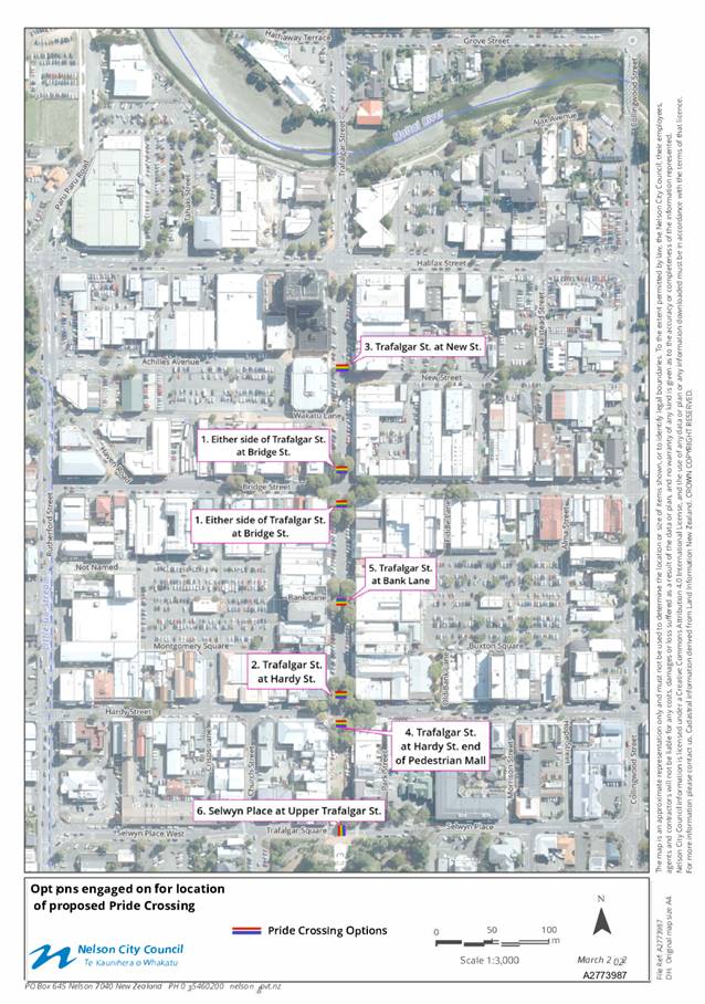
Item
8: Pride Crossing - Way Forward: Attachment 3
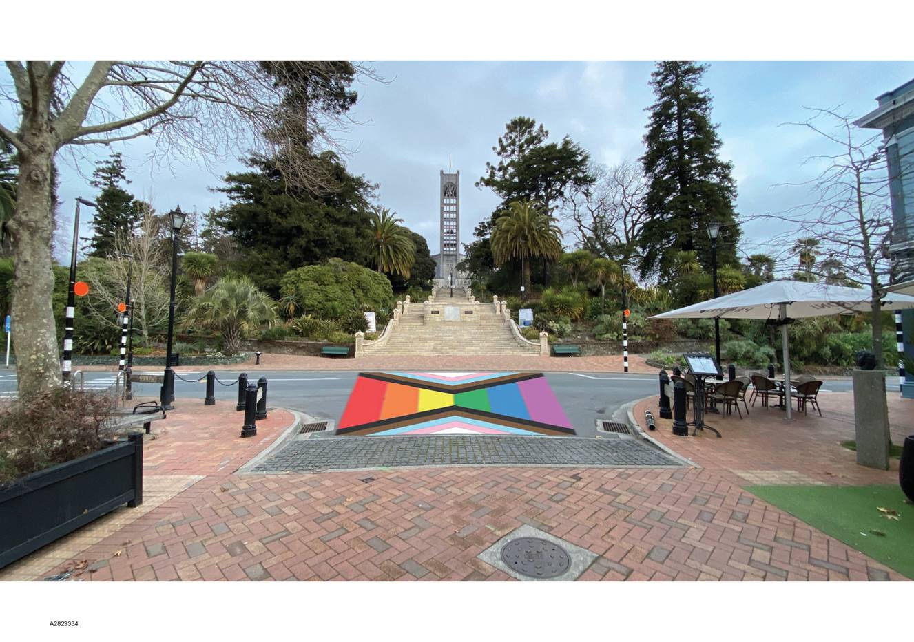
Item
8: Pride Crossing - Way Forward: Attachment 4
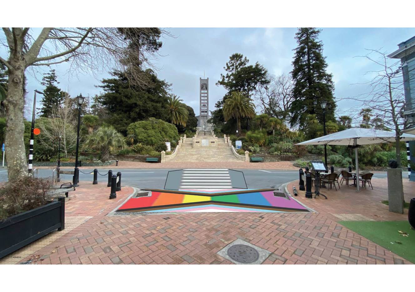
Item
8: Pride Crossing - Way Forward: Attachment 4
|
|
Infrastructure Committee
31 March 2022
|
REPORT R26525
Sandbag
Policy Options
1. Purpose
of Report
1.1 To
consider options for provision of sandbags to protect private property prior
to/during flood events.
2. Summary
2.1 Council
currently does not provide sandbags (either bags or sand) to protect public
property prior to or during flood events. Instead, priority is given to the
protection of key public assets (such as pump stations), and to measures to
reduce the general flood risk (to shore up weak points along riverbanks).
2.2 Different
councils around the country take different approaches although generally there
is no commitment made to providing sandbags to protect specific properties
unless there is known recurring flooding.
2.3 The
general provision of sandbags to private property owners is not supported by
the Nelson Tasman Civil Defence Management Group.
2.4 Providing
sandbags for general use has cost implications relating to purchase and storage
of sandbag materials and presents some risk to Council relating to community
health and safety, liability and reputation.
2.5 Maintaining
a policy of not providing sandbags for individual use sends a clear message
that individuals need to take responsibility for making arrangements to protect
their property. This needs to be accompanied with clear messaging to all
ratepayers and clear information to those potentially affected property owners
on actions that they can take to prepare for flood events.
3. Recommendation
|
That the Infrastructure Committee
1. Receives
the report Sandbag Policy Options (R26525)
and its attachments (A2840348, A2840350).
|
Recommendation to Council
|
That the
Council
1. Confirms that Council does not
support the general provision of sandbags, sand or bags, to private property
owners/occupants prior to or during flood events; and
2. Notes that officers are working in
conjunction with the Nelson Tasman Emergency Management Group to promote
flood readiness to the community, and specifically to those property owners
located within the flood hazard/coastal inundation overlay.
|
4. Background
4.1 Prior
to 2011, Council’s contractors used to hold and supply two pallet loads
of sandbags which would be delivered and deployed on request to private
properties. In December 2011, the region experienced an extreme weather event,
with conditions and demand on resources (council officers, Civil Defence and
contractors) making it impossible for Council and its contractors to provide
sandbags to all those who requested help.
4.2 During
subsequent events, priority was given to protecting Council assets. Public
requests for help to protect private property were declined.
4.3 At
the Deliberations Meeting for the Long Term Plan 2018-2018 held on 15 May 2018,
Council considered a submission that identified the risks of flooding and
coastal inundation due to sea level rise. After deliberating on the issue,
Council resolved as follows:
Requests that officers
investigate potential options to store sand and bags to make available for
community use prior to an emergency and report back to the Works and
Infrastructure Committee.
4.4 Whilst
some preliminary investigative work did start in the 2018/19 year, it has been
treated as a lower priority issue by staff given other pressures on staff
resource, particularly in the Infrastructure group.
5. Discussion
5.1 The
provision of sandbags immediately prior to, or during, flood events presents
some significant logistical challenges. These include:
5.1.1 Resource
Constraints
· Council
and its contractors prioritise the protection of Council assets including pump
stations, buildings and roads and the clearing of watercourses, bridges,
stormwater intakes, culverts and sumps through sandbagging as necessary.
Providing sandbags prior to an event diverts effort away from critical
preparation works and providing sandbags during an event diverts effort away
from critical focussed response. The time and effort required to set up,
deliver and place sandbags to private properties would take key workers away
from that primary focus.
· Storage
of sand and bags or filled sandbags needs to be located in areas accessible by
those at risk of flood. Filled bags are perishable and have limited lifespan.
· In 2011
the extent of the damage from the extreme rainfall event to the wider area was
such that is was impossible for contractors to move around the city to deal
with critical assets let alone private property.
5.1.2 Confused
Public Messaging
· People’s
individual safety is paramount during significant flood events, with property
being a secondary consideration. People should not be endangering their safety
trying to protect property. Key messages should refer to moving valuables and
pets to higher parts of their property and on ensuring they can evacuate safely
and in keeping sumps clear to facilitate proper drainage.
· Determining
appropriate trigger levels as to when to potentially provide sandbags could be
confusing and create a heavy workload for both Council officers and
contractors.
5.1.3 Effectiveness
· Sandbagging
is not always effective. It may give people a false sense of security when they
should be preparing to evacuate.
· Poorly
constructed barriers are prone to failure.
· Sandbags
that have been wet or exposed to UV light will start to disintegrate and become
less effective.
· A
comprehensive review (The Pitt Review[1])
for the United Kingdom’s Environment Agency following the 2007 floods
found:
Strategic sandbagging can be
successfully used alongside roads or adjacent to important buildings to prevent
them from flooding, but the work needs to be done properly by experts. The
Review was unable to obtain any significant evidence that sandbags were
particularly effective during the 2007 summer floods in providing protection to
individual households
5.1.4 Health
and Safety
· Multiple
people trying to access a distribution site whilst there is a flood warning in
place has the potential to cause congestion, putting those people at risk.
· Filling
and carrying sandbags can be hazardous, particularly to people who are less
physically able.
· In
severe floods, evacuation may be delayed whilst people try to protect their
property.
· Post-flooding,
sandbags that have often been in contact with contaminated water, pose handling
risks and contamination to the wider public.
5.1.5 Equity
· Use of
sandbags requires access to them, physical ability and knowledge of how to use
them. Where sandbags are provided, it is on a first-come first-served basis.
Some people will miss out.
6. Civil
Defence Emergency Management Group (NTEMG)
6.1 The
NTEMG appreciates the reasoning behind the current approach. It supports that
more could be done across agencies to provide readiness messages in relation to
flood preparedness. However, key messages during flood events should focus on
ensuring people are safe.
6.2 There
may be situations (e.g. under a declared State of Local Emergency) where
sandbags (or other flood prevention devices) are deployed as conditions
dictate. However, the general provision of sandbags to private property owners
is not supported.
7. Other
Councils’ Approaches
7.1 Different
Councils around the country take different approaches to the provision of
sandbags during flood events. The majority spoken to have a similar position to
that currently used by Council, i.e. whilst sandbags may be deployed by
Councils to protect assets, they are not made available for individual use.
These include Auckland City Council, Tasman District Council, Napier City
Council, Timaru District Council and Stratford District Council.
7.2 A
few exceptions were found:
7.2.1 Marlborough
District Council will provide a pallet of sandbags to streets likely to be
affected by flooding within the urban area. Individuals can use these to
protect their own properties.
7.2.2 Dunedin
City Council makes sandbags available to those potentially affected by
flooding. There have been several flood events in South Dunedin over the last
eight years.
7.2.3 Christchurch
City Council has provided sandbags to residents, most recently when stormwater
infrastructure was damaged.
7.2.4 Buller
District Council, operating under a State of Emergency, supplied over 20,000
bags and sand for volunteers to fill during the February 2022 rainfall event.
7.3 No
other Council was found to have a formal sandbag policy. However, examples of information
provided by Ōpōtiki District Council (webpage) and Auckland
Council-Emergency Management (flyer) are attached (Attachments 1 and 2).
8. Costs
8.1 The
key costs relate to purchase of sand and bags, storage facilities and labour
associated with distribution and collection of sandbags (or their components)
before, during and after a flood event. Whilst costs could be reduced if
Council and/or its contractors did not have to deliver sandbags to private
properties, additional costs would be incurred for traffic management and post
clean-up of any storage and distribution sites.
8.2 Standard
sandbags cost around $5 each at retail outlets. Council could purchase empty
sandbags (around $1 each) and sand in bulk ($30/tonne – one tonne fills
50 sandbags). Labour costs for filling the bags would be additional.
8.3 Council
could rely on volunteers to fill bags, but this would involve additional health
and safety responsibilities for and management from Council. Alternatively, it
could ask contractors to fill the bags, but as previously indicated, this will
take them away from other key priority flood prevention activities.
8.4 Whilst
Council could identify storage and distribution sites for Nelson and Stoke,
such as Trafalgar Park and Saxton Field, work would be required on developing
traffic management plans for use in an emergency event and there would be costs
incurred for any post clean-up works.
9. Alternatives
to Council Provision of Sandbags
9.1 Those
Councils that do not provide sandbags generally make clear information
available to property owners on their responsibilities and options (see also
Attachments 1 and 2).
9.2 Co-ordination
with NTEMG is ongoing to ensure general readiness messages, similar to those
provided for earthquakes and tsunamis. Supporting information (e.g. retailers,
how-to guides) is planned for the Council website.
9.3 Council
knows which properties are located within its flood and inundation zones within
the Nelson Resource Management Plan. It could provide additional targeted
communication with those properties to enhance awareness and enable those
property owners to make their own arrangements prior to a flood event taking
place.
10. Options
10.1 Council
can either continue with its existing position of not providing sandbags, or
could develop a policy setting out when and how sandbags would be provided.
Officers support Option 1: Status quo
|
Option 1: Status quo – do not provide
sandbags to individual property owners/occupants
|
|
Advantages
|
· Doesn’t
divert key resource and focussed effort away from higher priority flood
response activities
· No
additional costs to Council or resource required
· Allows
messaging during events to focus on keeping people safe
· Avoids
health and safety and general liability risks associated with the provision
of sandbags
|
|
Risks and Disadvantages
|
· Some
people may see Council contractors sandbagging Council infrastructure during
a flood event, and feel that their property should also be protected by the
Council
· May
result in some properties being flooded during an event. This can be
partially mitigated by encouraging occupants to make plans in advance to
protect their key valuables/pets etc.
|
|
Option 2: Develop a
policy setting out when and how sandbags will be provided to individual
properties
|
|
Advantages
|
· Community
feels Council is being supportive
· May
decrease impacts of minor floods on some households
|
|
Risks and Disadvantages
|
· Focus
on sandbags can displace resources from other priority flood protection work
· Can
raise unrealistic expectation that properties can be protected from flood
events
· Some
additional costs to Council from storing/distributing sand and bags
· Potential
liability if Council commits to providing a service but then fails to deliver
· Health
and Safety of volunteers, contractors and individuals involved in filling,
carrying and stacking sandbags
· Undermines
message that individuals should take responsibility for preparing for natural
hazard events
|
11. Conclusion
11.1 Council
does not currently provide sandbags to protect individual properties during a
flood event. To do so would take key resources away from other, higher priority
activities, and could lead to an unrealistic expectation from the community
that the Council will always step in to protect their properties from floods.
11.2 Officers
recommend that the current position be maintained, and that better information
is provided to the community to enable them to take responsibility for their
own flood preparations.
Author: David
Light, Manager Utilities
Attachments
Attachment 1: A2840348 - Opotiki
District Council - About Sandbags Webpage - 16Feb2022 ⇩
Attachment 2: A2840350
- Auckland Council-Emergency Management - Guide to sandbag use for properties
at risk from king-tides - Dec2018 ⇩
|
Important considerations for decision making
|
|
1. Fit
with Purpose of Local Government
Providing sandbags to protect private properties is
not a core function of local government. Property owners/occupants are able
to source sandbags and sand from specialist retailers and landscape companies.
Council does have responsibility for providing flood protection, and an
efficient stormwater network. Sandbags provided to individual property owners
do not contribute to that activity.
|
|
2. Consistency
with Community Outcomes and Council Policy
The recommendation aligns with the community outcome
‘Our infrastructure is efficient, cost effective and meets current and
future needs’ and ‘Our communities are healthy, safe, inclusive
and resilient.’
|
|
3. Risk
The recommended option is the least risk option
identified. If Council were to commit to providing sandbags, it raises
increased health and safety, liability and reputational risks, as identified
in the report.
|
|
4. Financial
Impact
There is no financial impact from maintaining the
current position. If Council were to change that position, there would be
some additional costs. The main impact is on availability of contractors to
carry out other flood protection work during an event.
|
|
5. Degree
of Significance and Level of Engagement
This matter is of low significance because the
current policy position has been clearly articulated and there is low
expectation that Council will provide sandbags in an emergency event. The
recommended option includes providing increased information to the community.
|
|
6. Climate
Impact
Climate change is likely to result in increased
flood hazard across Nelson. Providing sandbags is not an effective or
efficient way of mitigating this risk. There is a risk that Council creates
an unrealistic expectation that it will provide sandbags to protect property
from these events.
|
|
7. Inclusion
of Māori in the Decision-making Process
No engagement with Māori has been undertaken in
preparing this report.
|
|
8. Delegations
The Infrastructure Committee has the following delegations
to consider this issue
Areas of Responsibility:
· Stormwater
and flood protection
The Infrastructure
Committee has the following power to recommend to Council:
· Approval
of final versions of strategies, policies and plans
|
Item
9: Sandbag Policy Options: Attachment 1
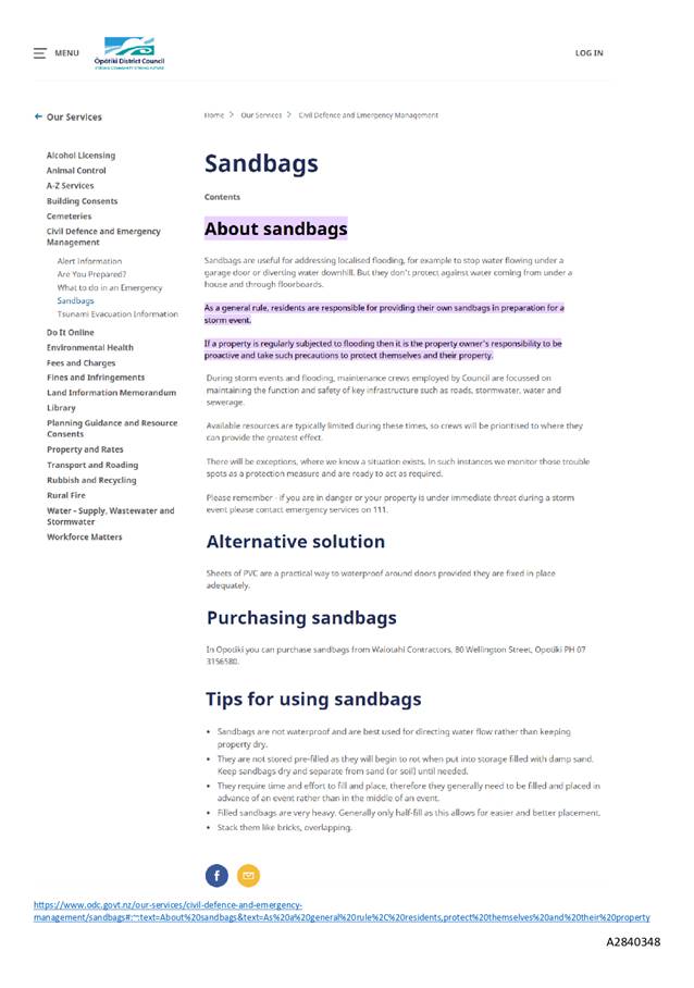
Item
9: Sandbag Policy Options: Attachment 2
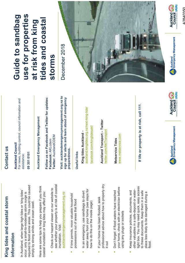
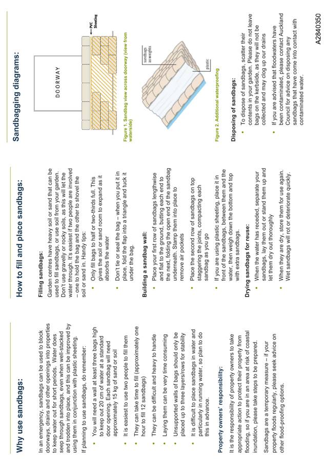
Item 10: Hampden Street
(west) Intersection with Waimea Road- Long term closure to motor
vehicles
|
|
Infrastructure Committee
31 March 2022
|
REPORT R26581
Hampden
Street (west) Intersection with Waimea Road- Long term closure to
motor vehicles
1. Purpose
of Report
1.1 To
present to the Committee the results of the final community feedback regarding
the long-term closure to vehicular access through the intersection of Waimea
Road and Hampden Street (west).
1.2 To
approve the long-term closure of the Waimea Road and Hampden Street (west)
intersection to vehicular traffic under existing powers of the Local Government
Act (section 319).
2. Recommendation
|
That the Infrastructure Committee
1. Receives
the report Hampden Street (west) Intersection with Waimea Road-
Long term closure to motor vehicles (R26581) and its attachment (A2846492); and
2. Determines that the intersection of
Waimea Road and Hampden Street (west) be closed to vehicular traffic long-term
by determining under section 319(1)(f) of the Local Government Act 1974 that
part of the Hampden Street road west of Waimea Road is a footpath and cycle
track.
|
Recommendation to Council
|
That the
Council
1. Approves that the intersection of
Waimea Road and Hampden Street (west) be closed to vehicular traffic
long-term by determining under section 319(1)(f) of the Local Government Act
1974 that part of the Hampden Street (west) road is footpath and cycle track.
|
3. Background
3.1 The
background to this matter is not replicated in this report but is covered
through the latest report presented to the 24 February 2022 Infrastructure
Committee, linked
here.
3.2 In
February 2022 the Infrastructure Committee:
Resolved IC/2022/001
2. Determines
that there is sufficient information available from the feedback and monitoring
process on the Waimea Road and Hampden Street (west) intersection trial
summarised in this report (R24828) to enable the Council to seek community
views on a proposal to close the intersection to vehicular traffic by
determining under section 319(1)(f) of the Local Government Act 1974 that part
of Hampden Street is footpath; and
4. Notes
a report summarising the community views of the proposal will be brought back
to a future Committee for decision.
Discussion
3.3 Council
has power under the s319 Local Government Act to determine what part of a road
shall be a carriageway, and what part a footpath or cycle track.
3.4 Based
on the data and early public feedback since the beginning of the temporary
closure, officers recommend that this part of Hampden Street (west) is closed
to vehicular traffic long-term by way of determination under s 319 LGA 1974
that this part of the road is footpath and cycle track, and in February/March
2022 sought final community views on this.
3.5 In
preparing this report, Council officers have sought final feedback on long term
closure from previously identified key stakeholders including Victory and
Hampden Street Schools, Nelson Intermediate, Nelson College, the AA, Nelsust,
Bicycle Nelson Bays, Fire and Emergency NZ, NMDHB and the Police. Support for
long term closure of Hampden Street had previously been signalled by the AA, NZ
Police, Nelsust, Bicycle Nelson Bays, FENZ, St John Ambulance and the NMDHB.
The AA, Bicycle Nelson Bays and NMDHB responded a second time reaffirming their
support for the closure. Hampden Street school replied supporting the closure,
but still favour traffic signals at the intersection.
3.6 Additional
public feedback since February 2022 has been gathered through Shape Nelson, social media posts, an email to all previous submitters
and a dedicated mail drop to approximately 350 residents/homeowners and
business owners’ letterboxes. A copy of the letter is appended as
Attachment 1.
3.7 Overall
feedback supports the long-term closure by determination under s319 LGA that
part of the road is footpath and cycle track. A total of 68 responses were
received and 81% of the responses supported the closure, many commenting on the
improved feelings of safety as a result. Another 15% opposed the long-term
closure and 4% did not know.
3.8 Suggestions
were received about the placemaking aspect of the closure requesting trees, art
and a safe waiting area for parents collecting or dropping off school children.
An improved parking layout and turning head, and separate facilities for
cyclists and pedestrians were also requested. Some concerns were raised about
provision of seating in the area. If long term closure is approved and that
part of the road is determined to be footpath and cycle track, work will begin
on design, taking these suggestions into consideration.
3.9 A
small number of Kawai Street residents raised concerns about the effect the
current temporary closure has had (increased volumes between Alfred and
Franklyn Street) and called for additional traffic calming and controls
including Compulsory Stop signage at the Hampden Street and Kawai Street
intersection. These suggestions will be considered by officers as part of the
ongoing safety and speed control improvements on the network.
3.10 Three
submitters, including Hampden Street School, requested traffic signals at the
intersection. As stated in the 24 February 2022 report to the Infrastructure
Committee, officers advise further investigation is required to understand the
wider area impacts of signalising the Hampden Street intersection and how to
accommodate or mitigate the changes in traffic flows and a business case made.
The current recommendation does not prohibit traffic signals as a future
option.
4. Options
4.1 Having
considered the monitoring results presented and final public and key
stakeholder feedback, two options for the intersection have been identified
–close the intersection long-term by determining under s 319 LGA 1974
that the road is footpath and cycle track, or do nothing in which case the
temporary closure will lapse and the road will remain carriageway and be
re-opened to vehicles. Officers recommend option 1.
|
Option 1: Close the
intersection by exercising power under
Section 319 LGA 1974 to determine the road is footpath and cycle track
|
|
Advantages
|
· Removes known high crash risk at this location
· Supports safer walking and cycling routes to the
local schools
· Responds to the public and stakeholder support for
the permanent closure of the intersection to motorised vehicles
· Opportunity for placemaking
· Provides a safer intersection as part of the broader
‘Cross Town Links’ active mode route being developed by Council
· The area retains its road reserve status which has
required flexibility and mechanisms for operating utility operators’
licenses and access
|
|
Disadvantages
|
· Some residents may feel aggrieved that the long-term
closure of the intersection to vehicles following a determination that part
of the road is footpath and cycle track will negatively impact them.
|
|
Option
2: Do nothing – temporary closure lapses, road at Hampden Street (west)
remains carriageway and is opened to vehicles
|
|
Advantages
|
· Allows reallocation of funding
· Meets calls from some residents to reopen intersection.
|
|
Risks and Disadvantages
|
· Reopening of road to vehicles would reintroduce
known high safety risk for vulnerable users, such as cyclists and pedestrians.
· Loss of opportunity to support modal shift.
· Lost opportunity for place making.
· Encourages inappropriate use of the network.
· Requires removal of increased parking on Waimea Road
that was gained when the intersection was temporarily closed.
· Negative feedback from those that support the
closure
· Reputational risk
|
5. Conclusion
5.1 Based
on the data, extensive engagement, and public feedback since the beginning of
the temporary closure, officers recommend that vehicle access to Hampden Street
(west) from Waimea Road is closed long-term by determination under s 319 LGA
1974 that part of the road is footpath and cycle track. Council has powers
under the 319 Local Government Act to determine what part of a road shall be a
carriageway, and what part a footpath or cycle track only. Officers have
completed a final round of engagement giving public notice of proposal to close the intersection to vehicular traffic for
the long-term by determining under s 319(1)(f) Local Government Act 1974 that
part of Hampden Street is footpath and cycle track and this is supported
by the majority of respondents.
6. Next
steps
6.1 If
Council determines that part of the road at Hampden Street (west) is
footpath and cycle track, the temporary planter boxes will remain in place
while officers will carry out final design with planned implementation planned
next financial year.
Author: Margaret
Parfitt, Manager - Transport and Solid Waste
Attachments
Attachment 1: A2846492 Resident
letter inviting feedback on long term closure of Hampden Street ⇩
|
Important considerations for decision making
|
|
Fit with Purpose of Local Government
Closing the road to vehicles by determining
that part of the road at Hampden Street (w
est) is footpath
and cycle track will meet the current and future needs of the Nelson
Community in a cost effect manner for the ratepayers. This decision fits with
the purpose of local government by providing support for social and
environmental well-being by demonstrating Nelson’s support for active
transport.
|
|
Consistency with Community Outcomes and Council
Policy
This recommendation supports the
following community outcomes:
· “Our
communities are healthy, safe, inclusive and resilient.”
· “Our
urban and rural environments are people friendly, well planned and
sustainably managed”
· “Our
communities have access to a range of social, educational and recreational
facilities and activities’.
In addition, it supports the Council priority to
create a sustainable transport culture and supports the Regional Land
Transport Plan 2021-31 (RLTP) vision to have a safe and connected region that
is liveable, accessible, and sustainable.
|
|
Risk
Risk to Council is low. Council has power
under section 319 of the LGA 1974 respect of roads to determine what part of
a road shall be a carriageway, and what part a footpath or cycle track. The
final round of engagement and public notice has provided the opportunity for
community to provide feedback on a section of Hampden Street (west) that is
currently carriageway being determined as a foot and cycle path.
|
|
Financial impact
Long term closure to motor vehicle traffic will
incur cost to design and install but this is provided for within existing
budgets.
|
|
Degree of significance and level of engagement
This decision to close the intersection of Waimea
Road and Hampden Street (west) to motor vehicle traffic for the long term and
determine part of Hampden Street west is a foot and cycle path, is a matter
of medium significance to the community. A great deal of data and information
about the effectiveness of the intervention and the views and preferences of
affected parties has been collected. To enable the Council to consider
exercising its General powers under section 319 of the
Local Government Act 1974 with confidence, officers have carried out a
further final round of engagement on the specific proposal to close the
intersection to traffic on a long term basis.
|
|
Climate Impact
The report recommendation has considered the
potential impacts and risks climate change presents to the City.
Encouragement or support of active travel modes may result in reduced
transport emissions and is an example of leadership.
|
|
Inclusion of Māori in the decision making
process
No engagement with Māori has been undertaken in
preparing this report.
|
|
Delegations
The Infrastructure Committee has the following delegations
Areas of Responsibility:
Transport network, including, roading network and
associated structures, walkways, cycleways and shared pathways, footpaths and
road reserve, street lighting, traffic management control and parking.
Delegations:
§ The committee has all of the
responsibilities, powers, functions and duties of Council in relation to
governance matters within its areas of responsibility, except where they have
been retained by Council, or have been referred to other committees, subcommittees
or subordinate decision-making bodies.
§ The exercise of Council’s
responsibilities, powers, functions and duties in relation to governance
matters includes (but is not limited to):
§ Undertaking community engagement,
including all steps relating to Special Consultative Procedures or other
formal consultation processes
Powers to Recommend to Council:
In the following situations the committee may
consider matters within the areas of responsibility but make recommendations
to Council only (in accordance with sections 5.1.3 - 5.1.5 of the Delegations
Register):
· Matters that, under the
Local Government Act 2002, the operation of law or other legislation, Council
is unable to delegate
· Decisions regarding
significant assets
|
Item 10: Hampden Street
(west) Intersection with Waimea Road- Long term closure to motor
vehicles

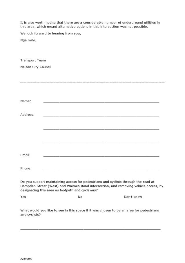

Item 11: Nelson Tasman
Regional Landfill Business Unit 2022/23 Business Plan
|

|
Infrastructure Committee
31 March 2022
|
REPORT R26658
Nelson
Tasman Regional Landfill Business Unit 2022/23 Business Plan
1. Purpose
of Report
1.1 To
receive the Nelson Tasman Regional Landfill (NTRLBU) 2022/23 Business Unit
(Business Plan).
2. Recommendation
|
That the Infrastructure Committee
1. Receives
the report Nelson Tasman Regional Landfill Business Unit 2022/23 Business
Plan (R26658) and its
attachment (A2796488).
|
3. Background
3.1 The
NTRLBU was established by the Nelson City Council (NCC) and Tasman District
Council (TDC) in April 2017 and became operational from 1 July 2017.
3.2 The
approved Terms of Reference (TOR) require that the Draft Business Plan be
presented annually to each Council by 31 October each year and allow for each
Council to provide feedback on the draft Business Plan.
3.3 The
Draft 2022/23 Business Plan was prepared by the NTRLBU General Manager and was
presented to the Board who resolved on 10 December 2021 as follows:
|
Approves the Nelson
Tasman Regional Landfill Business Unit Business Plan 2022/23 (A2796488) for
presentation to the Nelson City Council and Tasman District Council with the
following amendments as agreed by the NTRLBU on 10 December 2021:
· a
17% increase in landfill charges from 2021/22 to 2022/23
· amended
financials to reflect fee changes
· amended
Unique Emissions Factor
· expanded
Emissions Management Improvements section
· amended
Strategic Goals section to reflect whole-of-life management approach
· Clarification
of Deed of Agreement and Terms of Reference review.
Delegates all further
minor amendments to the Business Plan 2022/23 to the Nelson Tasman Regional
Landfill Business Unit Chairperson and General Manager.
|
Recommendation to Nelson City
Council and Tasman District Council
3.4 The
Business Plan was presented to the Infrastructure Committee (refer to report R26208)
on the 24 February 2022 where it was resolved as follows:
Provides
feedback to the Nelson Regional Sewerage Business Unit via the General Manager
of the Nelson Regional Sewerage Business Unit on the draft Nelson Regional
Sewerage Unit 2022/23 Business Plan (A2796488)
3.5 There
were no changes provided by the Committee on the Business Plan.
3.6 The
NTRLBU can only formally adopt the Draft Business Plan after receiving and
considering comment from the two Councils and is then required to present the
final Business Plan to the Councils by 31 May for inclusion in each
Council’s draft Annual Plan.
3.7 The
Board considered the comments and the Business Plan on the 25 March 2022 and
resolved as follows:
That the Infrastructure Committee
1. Receives the report
Nelson Tasman Regional Landfill Business Unit 2022/23 Business Plan (R26658) and its attachment/s () and its
attachment (A2796488); and
2. Approves the Nelson Tasman Regional Landfill Business
Unit 2022/2023 Business plan (A2796488) subject to minor changes approved by
the Chairperson; and
3. Recommends the Nelson Tasman Regional Landfill Business Unit Business Plan
2022/23 (A2796488) be presented to the Tasman
District Council and Nelson City Council.
Recommendation to Nelson City
and Tasman District Councils
That the Nelson
City and Tasman District Councils
1. Receive
the Nelson Tasman Regional landfill Business Unit Business Plan 2022/23
(A2796488).
4. Discussion
4.1 The
NTRLBU Business Plan is appended as Attachment 1 and the General Manager and
Board Chair will be present at the meeting to answer any questions.
5. Options
5.1 The
Committee has already considered the draft Business Plan and provided feedback
(of which there was none) to the General Manager, who has addressed that
feedback in the revised Business Plan and presented that back to the Board. The
Board has subsequently approved the Business Plan.
5.2 All
that remains is for both Council’s to receive that the Business Plan in
line with the TOR.
6. Conclusion
6.1 The
NTRLBU Business Plan 2022/23 has been approved by the NTRLBU Board and is now
presented to the two Councils.
Author: Alec
Louverdis, Group Manager Infrastructure
Attachments
Attachment 1: A2796488 - NTRLBU
Business Plan 2022-2023 ⇩
|
Important considerations for decision making
|
|
1. Fit
with Purpose of Local Government
The NTRLBU is a joint committee constituted pursuant
to the provisions of Schedule 7 to the Local Government Act 2002. A regional
landfill contributes to the four Local Government well-beings of social,
economic, environmental and cultural.
|
|
2. Consistency
with Community Outcomes and Council Policy
The draft Business Plan is required under the TOR to
be received by Council and included in the 2020/21 Annual Plan.
|
|
3. Risk
This report is of low risk as the Committee has
already considered the Business Plan and provided comment back to the Acting
General Manager. The risk of not receiving the Business Plan is that this
could delay the NTRLBU implementing their Business Plan for 2020/21.
|
|
4. Financial
impact
The NTRLBU 2020/21 Business Plan signals an increase
in landfill fees and charges, and this has been included in the 2020/21
Annual Plan.
|
|
5. Degree
of significance and level of engagement
The NTRLBU is a Joint Committee of the two Councils
and its activities are included in the Long Term Plans and Annual Plans of
each Council. Consultation is undertaken by both Councils in the
preparation and adoption of these plans.
|
|
6. Climate
Impact
The draft Business Plan includes a long-term
objective on greenhouse gas emissions with the commitment to measure and
reduce greenhouse gas emissions from the landfill.
|
|
7. Inclusion
of Māori in the decision making process
No engagement with Māori has been undertaken in
preparing this report, but iwi have representation on the Board.
|
|
8. Delegations
The Infrastructure Committee has the following
delegations to consider the Nelson Tasman Regional Landfill Business Plan:
5.6.1 Relevant
Areas of responsibility:
• Regional
Landfill
5.6.2 Delegations:
The exercise of Council’s
responsibilities, powers, functions and duties in relation to governance
matters includes
• Developing,
approving, monitoring and reviewing policies and plans, including activity
management plans and the Infrastructure Strategy
|
Item
11: Nelson Tasman Regional Landfill Business Unit 2022/23 Business Plan:
Attachment 1
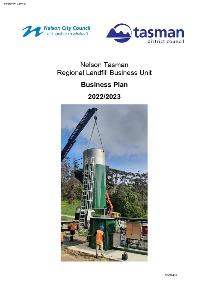
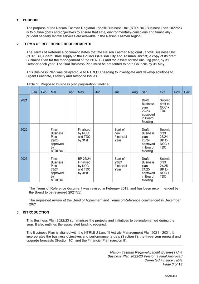
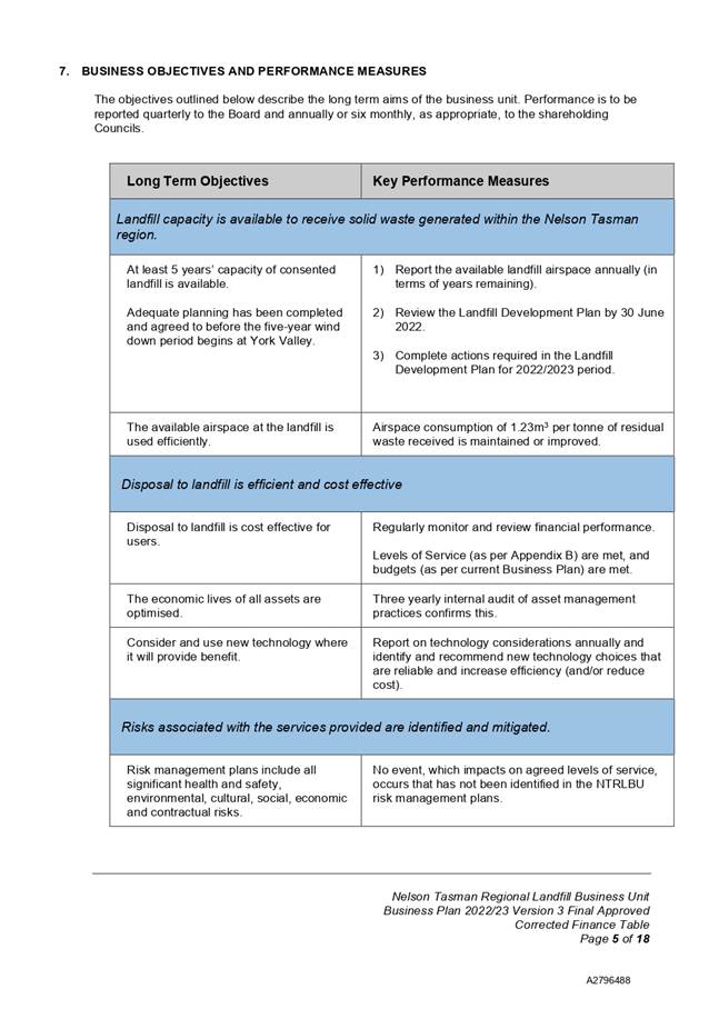
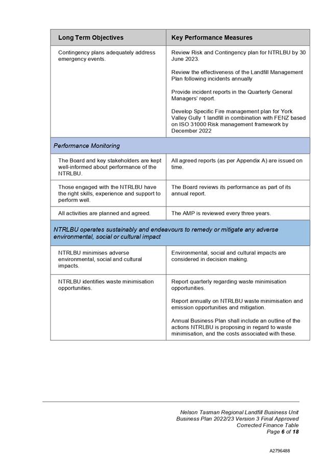
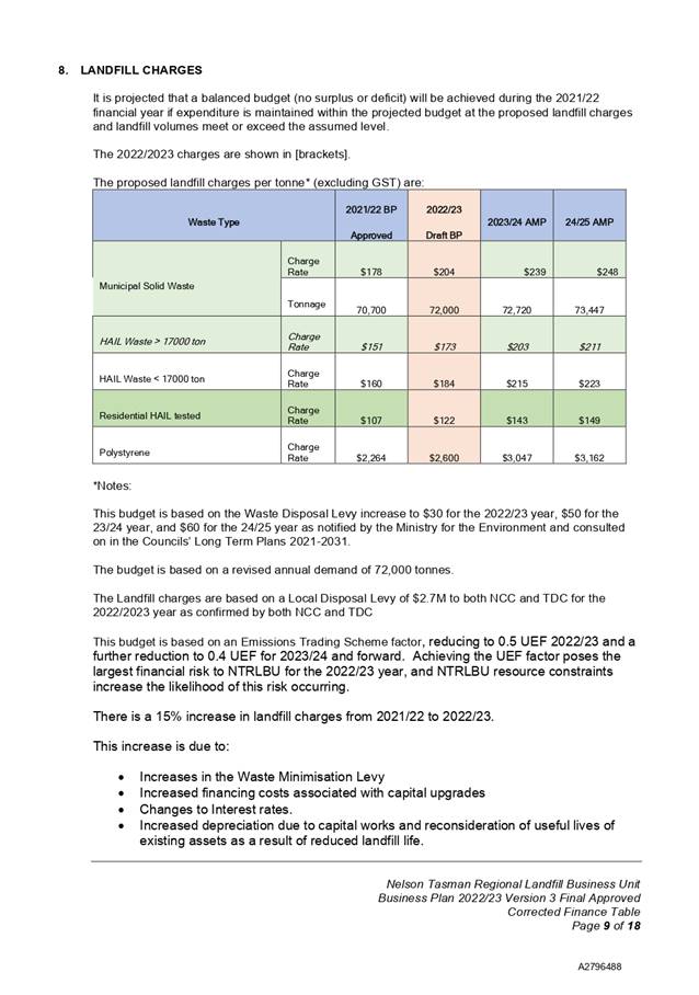
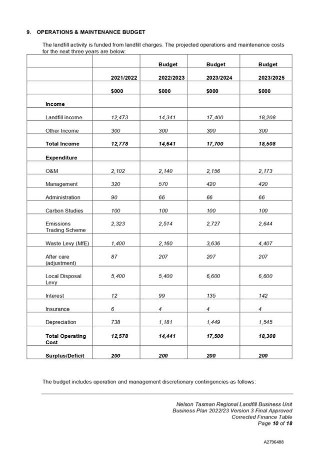
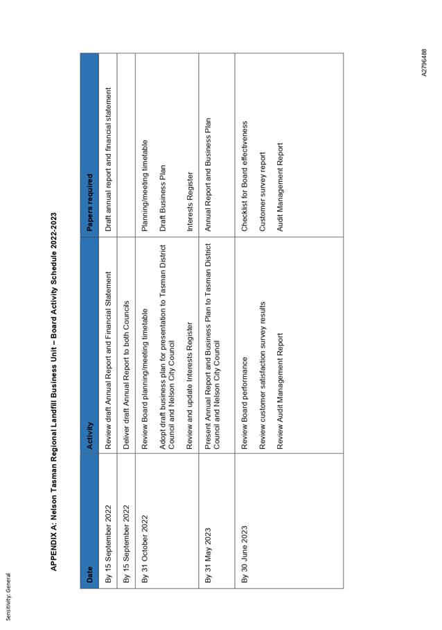
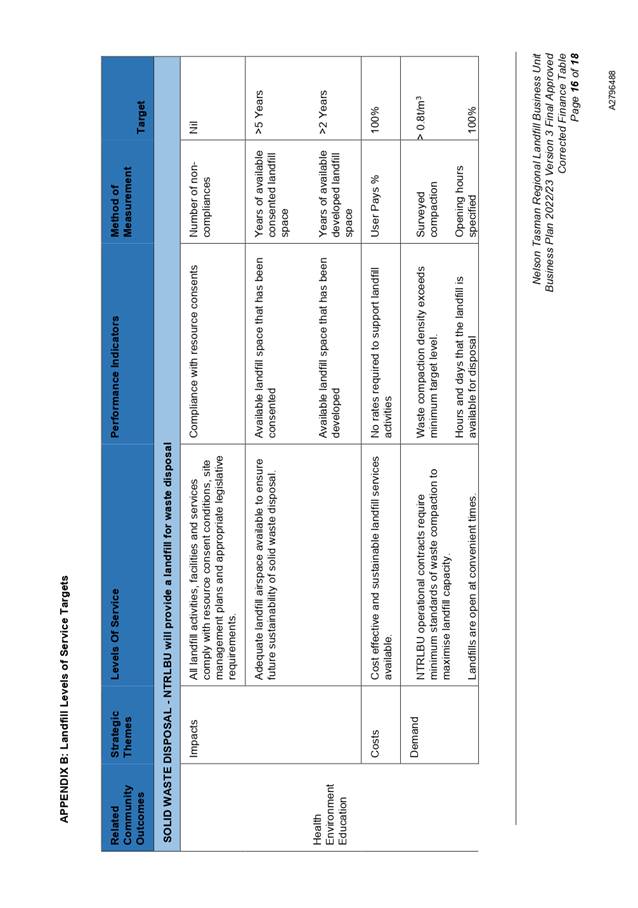
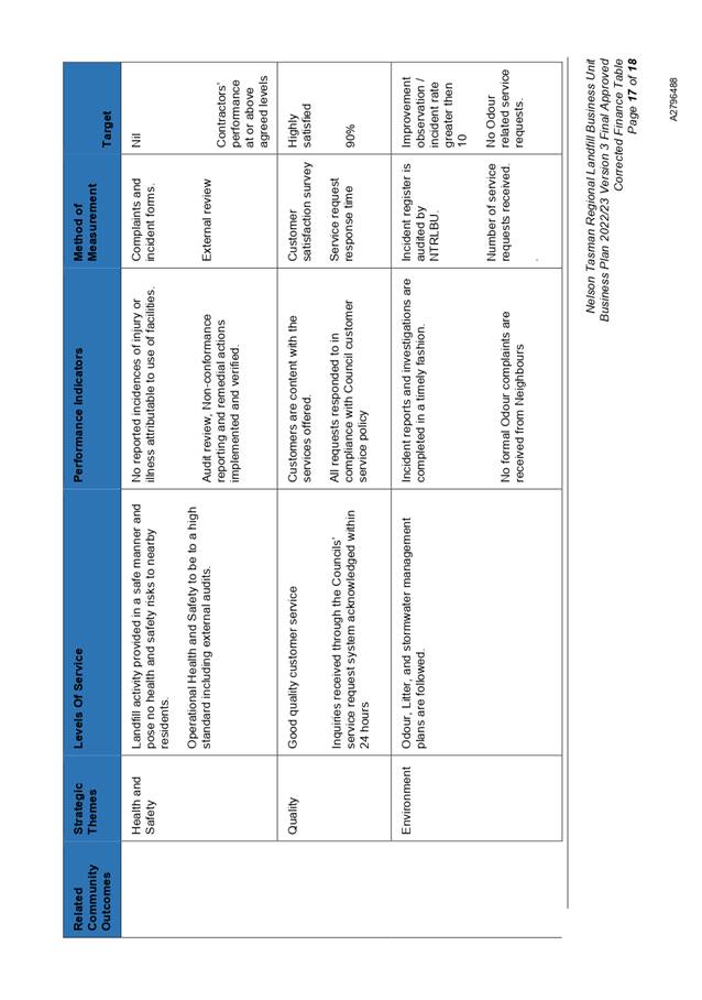
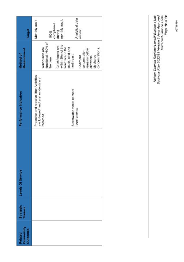
Item
11: Nelson Tasman Regional Landfill Business Unit 2022/23 Business Plan:
Attachment 1
|

|
Infrastructure Committee
31 March 2022
|
REPORT R26659
Nelson
Regional Sewerage Business Unit 2022/23 Business Plan
1. Purpose
of Report
1.1 To
receive the Nelson Regional Sewerage Business Unit (NRSBU) 2022/23 Business
Plan (Business Plan).
2. Recommendation
|
That the Infrastructure Committee
1. Receives
the report Nelson Regional Sewerage Business Unit 2022/23 Business Plan
(R26659) and its attachment (A2728794).
|
3. Background
3.1 The
NRSBU was established by the Nelson City Council (NCC) and Tasman District
Council (TDC) in July 2000. Its purpose is to manage and operate the wastewater
treatment facilities at Bell Island and the associated reticulation network
efficiently and in accordance with resource consent conditions and to meet the
needs of its customers.
3.2 The
five major customers are NCC, TDC, ENZA Foods, Alliance and Nelson Pine
Industries.
3.3 The
Memorandum of Understanding requires that the draft Business Plan be presented
annually to each Council by 31 December each year and allows for each Council to
provide feedback on the draft Business Plan.
3.4 The
draft 2022/23 Business Plan was prepared by the NRSBU General Manager and was
presented to the Board, who resolved on 17 September 2021 as follows:
|
“Approves the Draft Nelson Regional Sewerage Business Unit
Business Plan (A2728794) for submission to Nelson City Council and Tasman
District Council for their consideration and feedback”.
|
|
That the Nelson City Council and Tasman District Councils
Receive the Draft Nelson Regional Sewerage Business Unit
Business Unit Plan 2022-2023 (A2728794) for review and provide feedback to
the Nelson Regional Sewerage Business Unit if required.
|
|
3.5 The
Business Plan was presented to the Infrastructure Committee (refer to report R26207)
on the 18 November 2021 where it was resolved as follows:
Provides
feedback to the Nelson Regional Sewerage Business Unit via the General Manager
of the Nelson Regional Sewerage Business Unit on the draft Nelson Regional
Sewerage Unit 2022/23 Business Plan (A2728794)
3.6 That
report noted that the Draft Business Plan varied very little compared to the
programme and budgets outlined in the approved NRSBU AMP and in Council’s
Long-Term Plan (LTP) and that there were no implications to the NCC budget. The
General Manager was advised accordingly.
3.7 The
NRSBU can only formally adopt the Draft Business Plan after receiving and
considering comment from the two Councils and is then required to present the
final Business Plan to the Councils by 20 March, for inclusion in each
Council’s draft Annual Plan.
3.8 The
Board considered the Business Plan on the 11 March 2022 and resolved as
follows:
That the
Nelson Regional Sewerage Business Unit
1. Receives
the report Nelson Regional Sewerage Business Unit Business Plan Feedback
report. (R26681) and its attachment (A2728794); and
2.
Approves the Nelson Regional Sewerage Business Unit 2022/2023 Business
plan (A2728794) subject to minor changes approved by the Chairperson; and
3.
Recommends the Nelson Regional Sewerage Business Unit Business Plan
2022/23 (A2728794) be presented to the Tasman District Council and Nelson City
Council.
That the
Nelson City and Tasman District Councils
1.
Receive the Nelson Regional Sewerage Business Unit Business Plan 2022/23
(A2728794).
4. Discussion
4.1 The
NRSBU Business Plan 2022/23 is appended as Attachment 1 and the General Manager
and Board Chair will be present at the meeting to answer any questions.
5. Options
5.1 The
Committee has already considered the draft Business Plan and provided the
required feedback to the General Manager (of which there was none). The General
Manager has presented that feedback to the Board. The Board has subsequently
approved the Business Plan.
5.2 All
that remains is for both Council’s to receive that the Business Plan in
line with the Memorandum of Understanding.
6. Conclusion
6.1 The
NRSBU Business Plan 2022/23 has been approved by the NRSBU Board and is now
presented to the two Councils.
Author: Alec
Louverdis, Group Manager Infrastructure
Attachments
Attachment 1: A2728794 - NRSBU
Business Plan 2022-2023 ⇩
|
Important considerations for decision making
|
|
1. Fit
with Purpose of Local Government
The NRSBU is a joint committee constituted pursuant
to the provisions of Schedule 7 to the Local Government Act 2002 and
contributes to the four Local Government well-beings of social, economic,
environmental and cultural.
|
|
2. Consistency
with Community Outcomes and Council Policy
The Business Plan is required under the MoU to be
received by Council following comment and consideration by the Board.
|
|
3. Risk
This report is of low risk as the Committee has
already considered the Business Plan and provided comment back to the General
Manager. The risk not receiving the Business Plan is that this could delay
the NRSBU implementing their Business Plan for 2022/23.
|
|
4. Financial
impact
There is no change to the 2022/23 Business Plan to
that in the AMP and LTP.
|
|
5. Degree
of significance and level of engagement
The NRSBU is a Joint Committee of the two Councils
and its activities are included in the Long-term Plans and Annual Plans of
each Council. Consultation is undertaken by both Councils in the
preparation and adoption of these plans.
|
|
6. Climate
Impact
A key feature of the draft Business Plan is the
inclusion of a long–term objective of greenhouse gas emissions with the
commitment to measure and reduce greenhouse gas emissions from the facility.
|
|
7. Inclusion
of Māori in the decision-making process
No engagement with Māori has been undertaken in
preparing this report but iwi have representation on the Board.
|
|
8. Delegations
The Infrastructure Committee has the following
delegations to consider the Nelson Regional Sewerage Business Plan:
Relevant Areas of responsibility:
• Wastewater,
including Bell Island Wastewater Treatment Plant
Delegations:
The exercise of Council’s
responsibilities, powers, functions and duties in relation to governance
matters includes
• Developing,
approving, monitoring and reviewing policies and plans, including activity
management plans and the Infrastructure Strategy
|
Item
11: Nelson Tasman Regional Landfill Business Unit 2022/23 Business Plan:
Attachment 1
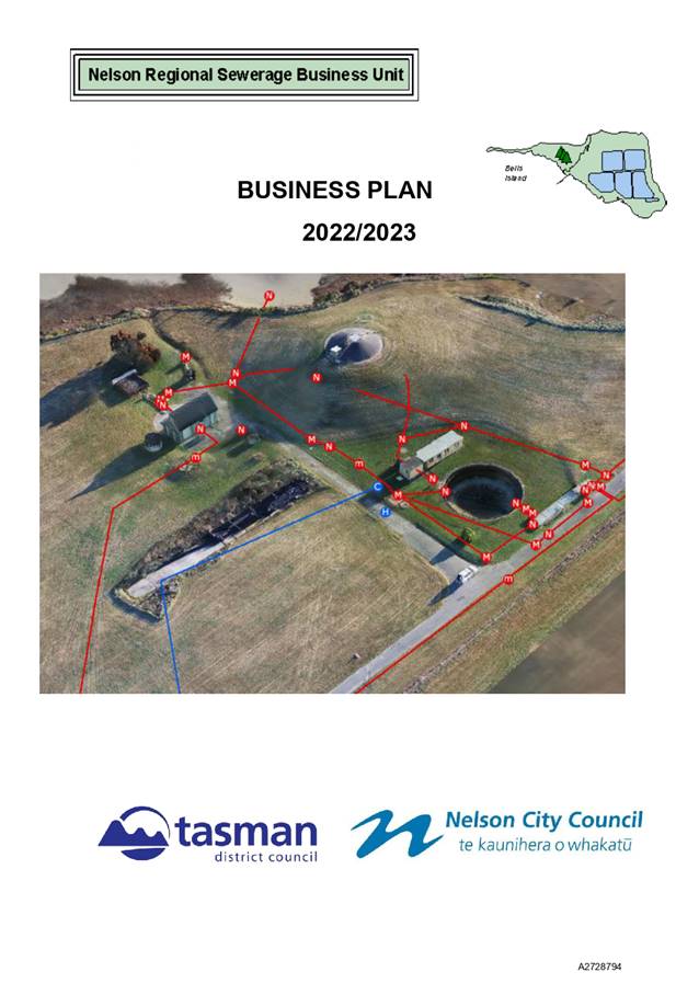

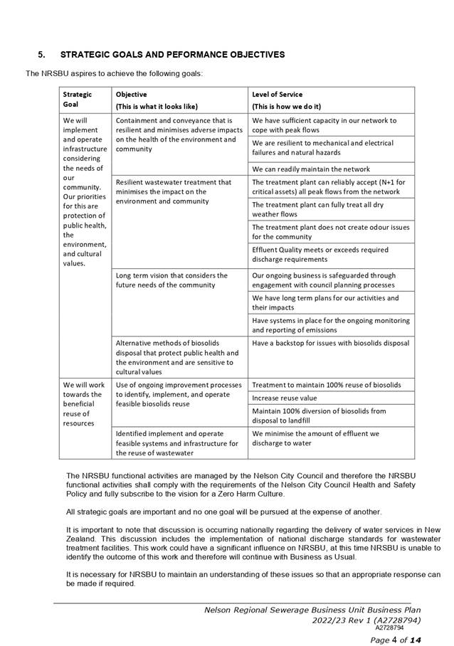
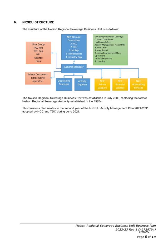
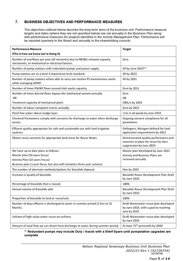
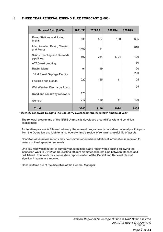
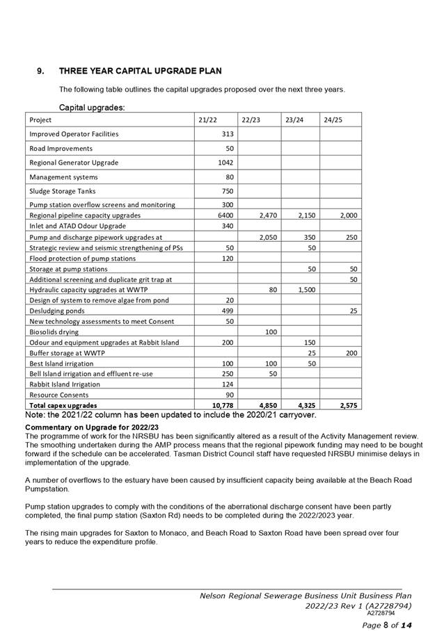
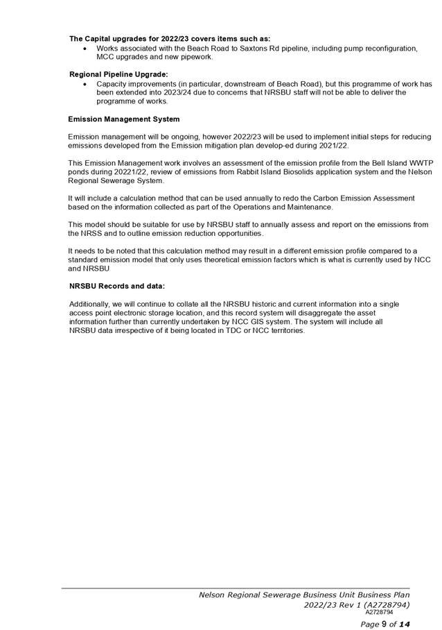
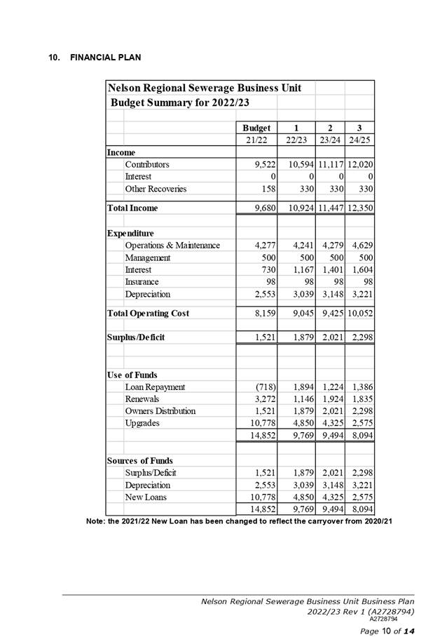
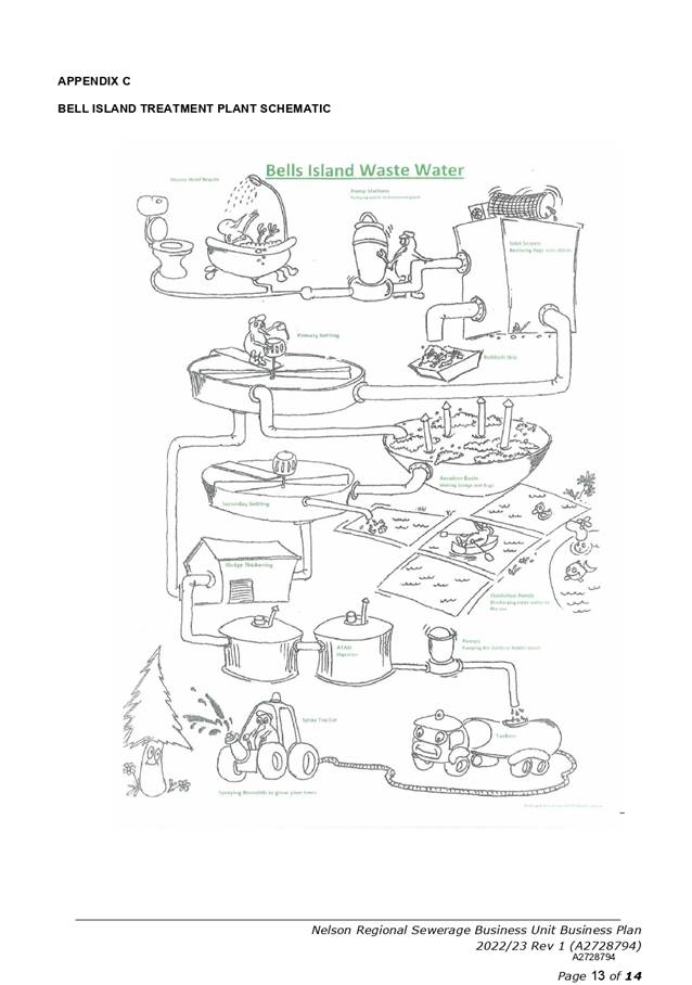
Item 13: Tahunanui
Catchment 4 Stormwater
|

|
Infrastructure Committee
31 March 2022
|
REPORT R26642
Tahunanui
Catchment 4 Stormwater
1. Purpose
of Report
1.1 To
recommend to Council to bring funding forward from 2024/25 into 2021/22 to
allow physical works to be undertaken on the Tahunanui Catchment 4 stormwater
upgrade.
2. Recommendation
|
That the Infrastructure Committee
1. Receives
the report Tahunanui Catchment 4 Stormwater (R26642) and its attachment (A2847780).
|
Recommendation to Council
|
That the
Council
1. Approves bringing forward budgeted
capital funding of $350,000 from 2024/25 to 2021/22, to allow early
completion of the Tahunanui Catchment 4 stormwater project in 2021/22.
|
3. Background
3.1 Council
has been carrying out a multi-stage study of the risk to and from the public
stormwater system within the Tahunanui Slump – an area of deep-seated
instability in Tahunanui that experiences ongoing and episodic periods of
accelerated movement in response to elevated groundwater levels and seismic
events. This movement has the ability to damage below ground infrastructure
such as concrete pipes.
3.2 The
Tahunanui Catchment 4 stormwater upgrade project is a multi-year project and is
a key project for this Council that will improve stormwater management in the
Tahunanui hills. Once completed, the new pipe will provide both primary and
secondary flow capacity for the catchment. Refer to Attachment 1 for
location.
4. Discussion
4.1 Due
to the developed nature of the area, many services run through private
property. The owner of the property, through which the stormwater pipe runs, is
intending to rebuild their house (including demolition) and this creates an
ideal opportunity for Council to upgrade the stormwater pipe through their
property at the same time.
4.2 The
project is tracking ahead of schedule with:
4.2.1 Negotiations
with landowners progressing faster than originally planned.
4.2.2 consultation
with key stakeholders complete including iwi, local businesses, residents,
community groups, utility providers, Waka Kotahi, and emergency services.
4.2.3 detailed
design plans complete.
4.2.4 resource
consent application lodged.
4.2.5 easement
agreed in principle with the property owner.
4.3 Early
contractor engagement has been undertaken with a local contractor at an early
stage of the design to understand risk, constructability, methodology and
optimisation of the design.
5. Financial
5.1 Funding
of $542,000 has been provided in the Long-Term Plan in 2024/25 for constructing
this project and this is a key project to improve stormwater management in the
Tahunanui area.
5.2 Officers
had included $350,000 in the draft 2022/23 Annual Plan to construct this
project, but now anticipate this money is required in 2021/22 for the reasons
described in this report.
5.3 Timing
of construction is dependent on the property owner’s house demolition
timeline. There is a risk of delays beyond council officer’s control,
which could lead to a subsequent full or partial carry over request.
6. Options
6.1 Two
options are presented as detailed below – approve or not approve bringing
funding forward from 2024/25. Officers support option 1.
|
Option 1: Approve bringing
funding forward. Recommended option
|
|
Advantages
|
· Work is
ready to go
· Good
understanding of the risks by all parties.
· Work
can be coordinated around timing of house demolition
· Reduced
flooding in private properties
|
|
Risks and Disadvantages
|
· Construction
timeline is dependent on house demolition timeline, risk of delays beyond
council officer’s control could lead to a full or partial carry over
request.
|
|
Option
2: Not approve the transfer. Not recommended
|
|
Advantages
|
· None
|
|
Risks and Disadvantages
|
· Project
costs substantially increase after the house construction is complete due to
risk of damage
· Property
owner not allowing work to proceed for fear of damage to new building.
|
7. Conclusion
7.1 Officers
recommend bringing forward $350,000 from 2024/25 to 2021/22 to allow award of
the physical works and enable progress of this important work.
8. Next
Steps
8.1 Once
approved, work will get underway as soon as practicable.
Author: Joel
Felber, Team Leader Capital Projects
Attachments
Attachment 1: A2847780 -
Tahunanui Drive - Catchment 4 - Location plan - 25 February 2022 ⇩
8.
|
Important considerations for decision making
|
|
Fit
with Purpose of Local Government
This construction project is part of the
Council’s LTP and meets the purpose of local government to promote the
social, economic, environmental, and cultural well-being of communities in
the present and for the future.
|
|
Consistency with Community Outcomes and Council
Policy
The recommendation in this report aligns with the
following Council’s community outcomes – “Our
infrastructure is efficient, cost effective and meets current and future
needs”, “Our communities are healthy, safe, inclusive and
resilient”, and “Our unique natural environment is healthy and
protected”. The project aligns with Council’s Annual Plan
and LTP.
|
|
Risk
If approval is not given, it is unlikely the works
can be completed within the LTP funding that is available due to increased
costs if the physical work was done after the property is developed.
Construction timeline is dependent on house
demolition timeline, risk of delays beyond council officer’s control
could lead to a full or partial carry forward request.
|
|
Financial impact
Adequate funding exists to deliver this stage of the
project.
|
|
Degree of significance and level of engagement
This matter is of low significance as the project
has been signalled in several LTP’s and Annual Plans. There will be
ongoing local consultation with businesses and residents, as per the formal
Public Consultation Plan developed for this project.
|
|
Climate Impact
The impact of climate is considered
in all projects.
|
|
Inclusion of Māori in the decision-making
process
No engagement with Māori has been undertaken in
preparing this report. Iwi have been consulted from an early stage of this
project to identify their requirements in respect to any areas of potential
cultural interest. An iwi monitor will be formally employed on
site during construction.
|
|
Delegations
The Infrastructure Committee has
the following delegation:
Areas of Responsibility:
·
Transport network, including, roading
network and associated structures, walkways, cycleways and shared pathways,
footpaths and road reserve, street lighting, traffic management control and
parking.
·
Water
·
Wastewater, including Bell Island
Wastewater Treatment Plant
·
Stormwater and Flood Protection
Delegations:
·
The committee has all of the
responsibilities, powers, functions, and duties of Council in relation to
governance matters within its areas of responsibility, except where they have
been retained by Council, or have been referred to other committees,
subcommittees, or subordinate decision-making bodies.
Powers to Recommend to Council:
·
Unbudgeted expenditure relating to the areas of
responsibility, not included in the Long-Term Plan or Annual Plan
|
Item
13: Tahunanui Catchment 4 Stormwater: Attachment 1