
AGENDA
Ordinary meeting of the
Works and Infrastructure Committee
Thursday 28 June 2018
Commencing at 9.00a.m.
Council Chamber
Civic House
110 Trafalgar Street, Nelson
Membership: Stuart Walker (Chairperson), Her Worship the
Mayor Rachel Reese, Councillors Luke Acland, Paul Matheson, Matt Lawrey, Gaile
Noonan, Tim Skinner and Mike Rutledge (Deputy Chairperson)
Guidelines for councillors
attending the meeting, who are not members of the Committee, as set out in
Standing Order 12.1:
·
All councillors, whether or not they are members of the
Committee, may attend Committee meetings
·
At the discretion of the Chair, councillors who are not Committee
members may speak, or ask questions about a matter.
·
Only Committee members may vote on any matter before the
Committee
It is good practice for both Committee members and
non-Committee members to declare any interests in items on the agenda.
They should withdraw from the room for discussion and voting on any of these
items.
 Works and Infrastructure
Committee
Works and Infrastructure
Committee
28
June 2018
Page
No.
1. Apologies
1.1 An
apology has been received from Her Worship R Reese
2. Confirmation
of Order of Business
3. Interests
3.1 Updates
to the Interests Register
3.2 Identify
any conflicts of interest in the agenda
4. Public
Forum
4.1 Stella Chrysostomou,
Church Street Committee, in support of the Church Street Project
4.2 Aaryn Barlow, Health
Promoter, Nelson Marlborough Health, in support of Tahunanui Cycle Network
Project
5. Confirmation
of Minutes
5.1 22 May
2018 8 - 13
Document number M3499
Recommendation
That the
Works and Infrastructure Committee
Confirms
the minutes of the meeting of the Works and Infrastructure Committee, held on
22 May 2018, as a true and correct record.
6. Chairperson's Report 14 - 17
Document number R9417
Recommendation
That the Works and Infrastructure Committee
Receives the Chairperson's Report
(R9417).
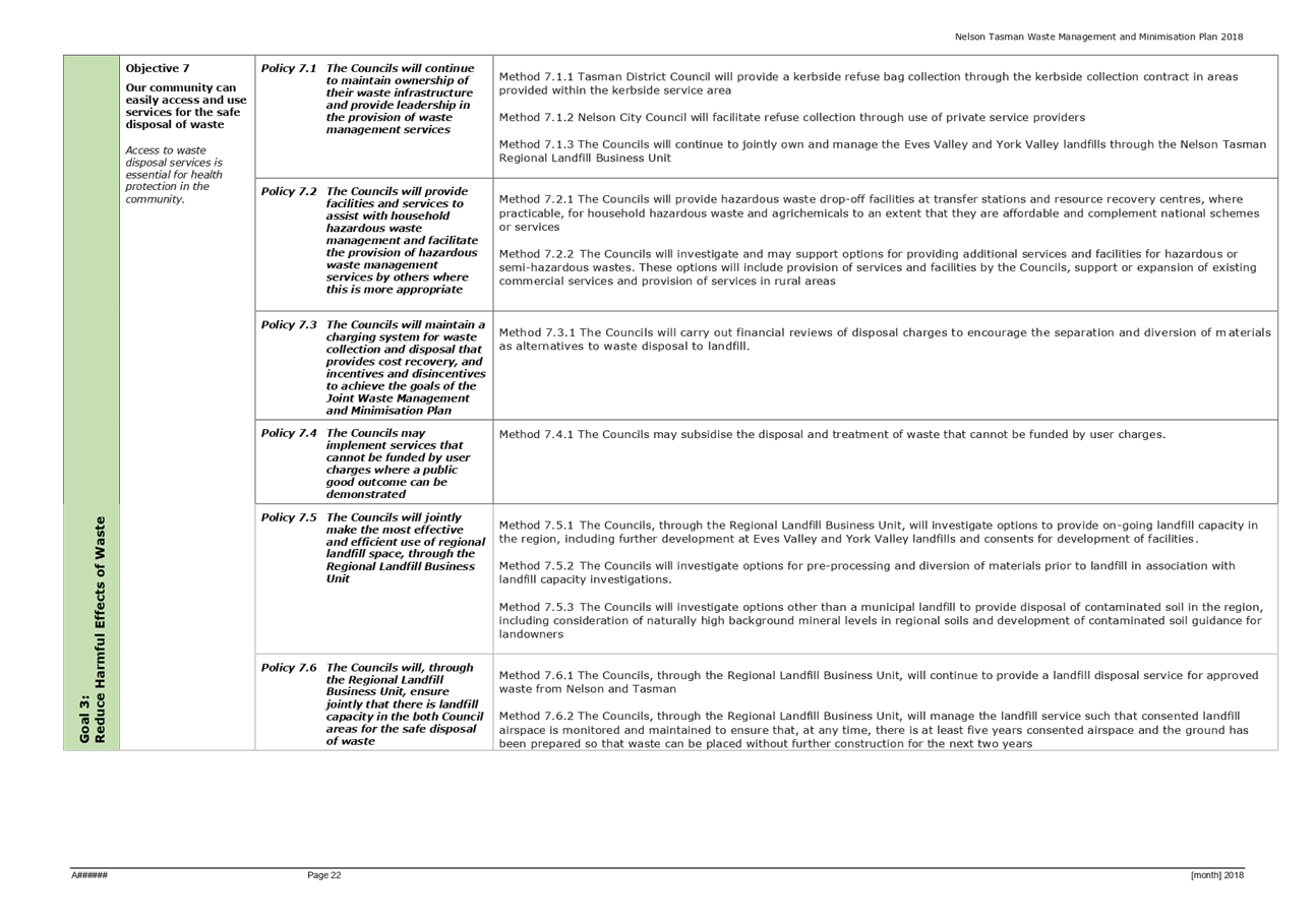
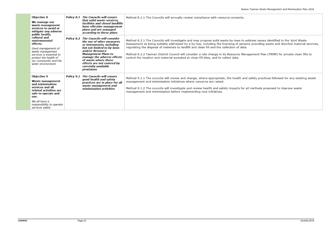
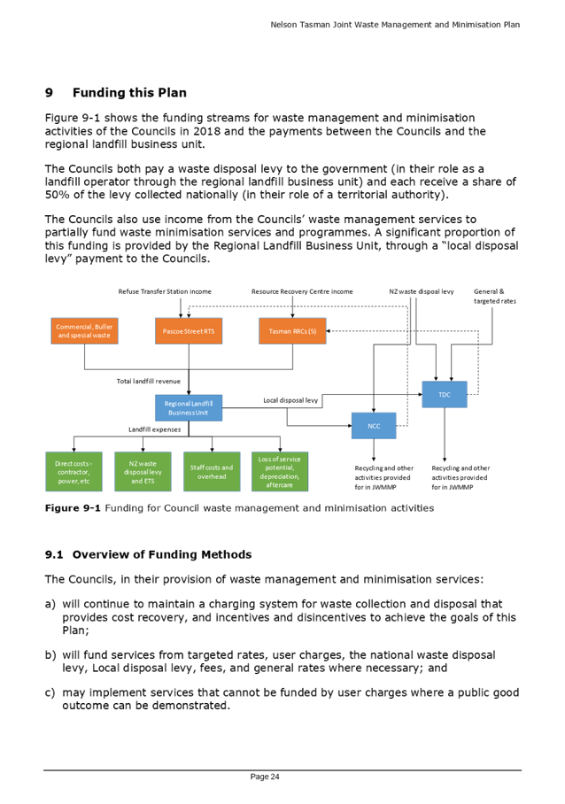
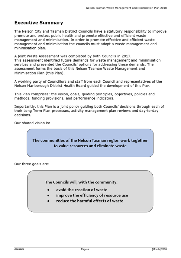
7. Joint Waste
Management and Minimisation Plan 18
- 75
Document number R8965
Recommendation
That the Works and Infrastructure
Committee
Receives the report Joint Waste
Management and Minimisation Plan (R8965)
and its attachments (A1831374, A1987259 and A1987256); and
Approves the Statement of Proposal
(A1987256 of report R8965) and the draft Joint Nelson Tasman Waste Management
and Minimisation Plan (A1987259 of report R8965) for the purposes of community
consultation subject to an equivalent resolution being passed by the Tasman
District Council; and
Delegates
authority to approve any minor changes to the draft Joint
Nelson Tasman Waste Management and Minimisation Plan (A1987259 of report R8965)
and Statement of Proposal (A1987256 of report R8965) to the Chair (Councillor
Kit Maling – Tasman District Council) and Deputy Chair (Councillor Stuart
Walker – Nelson City Council) of the Joint Nelson Tasman Waste Working
Party.
Recommendation to Council
That the
Council
Approves
the draft Joint Waste Management and Minimisation Plan (A1987259 of report
R8965) and the Statement of Proposal (A1987256 of report R8965) that will allow
the Special Consultative Procedure to commence.
8. Recycling -
Effect of International Markets 76 - 84
Document number R9280
Recommendation
That the Works and Infrastructure
Committee
Receives the report Recycling
- Effect of International Markets (R9280); and
Agrees
to continue with recycling in Nelson recognising the strong commitment from Nelsonians;
and
Agrees
to accept the costs resulting from the global drop in commodity prices, for the
2018/19 financial year at an estimated cost of between $88,500 and $94,500,
funded from current reserves in the Solid Waste account; and
Requests
a further follow-up report to a future Works and Infrastructure Committee in
early 2019 advising of the longer term future of recycling.
Recommendation to Council
That the
Council
Approves
the funding resulting from the global drop in commodity prices for the 2018/19
financial year at an estimated cost of between $88,500 and $94,500, funded from
current reserves in the Solid Waste account.
9. Tahunanui Cycle
Network - Preferred Option 85 - 119
Document number R8979
Recommendation
That the Works and Infrastructure Committee
Receives the report R8979
Tahunanui Cycle Network - Preferred Option , and its attachments (A1948256, and
A1979013); and
Approves
as the top priority for progression to targeted consultation, detailed design
and construction Option 1: Route 1 – Annesbrook Roundabout to Beach Road
as detailed in Report R8979; and
Recommends
the package of work as identified in Attachment 2 (A1979013 of Report R8979) to
be considered in the next review of the 2021-2031 Transport Activity Management
Plan and Council’s Long Term Plan 2021-2031.
10. Church Street Upgrade 120 - 145
Document number R9055
Recommendation
That the Works and Infrastructure
Committee
Receives the report Church Street
Upgrade (R9055) and its
attachments (A1990747, A1977465, A1977517, A1979152 and A1952746).
Recommendation to Council
That the
Council:
Approves Option 1 as presented in
Report R9055 at a total project cost of $1,330,000 to fund the Church Street
upgrade; and
Approves
additional unbudgeted funding of $551,000 for Option 1; and
Approves
the re-phasing of the project schedule and budget with $400,000 allocated to
2018/19 and $823,000 allocated to 2019/20, noting $107,000 has been spent to
date.
OR
Confirms
the additional costs are significant and unbudgeted and that any upgrade of
Church Street should be included in the City Centre Strategy being completed in
the 2018/19 year and prioritised accordingly.
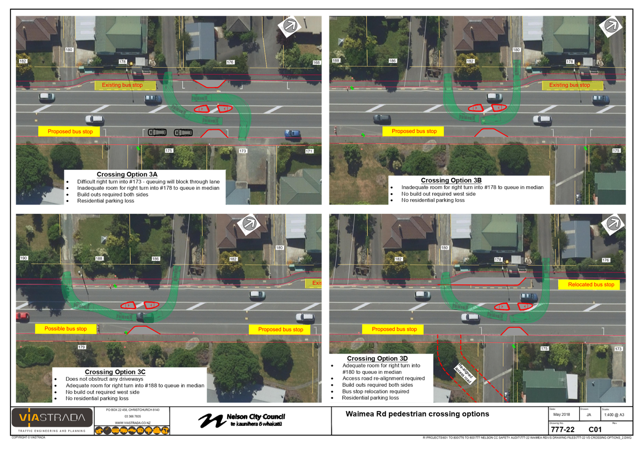
11. Waimea
Road Severance - Pedestrian refuges 146 - 160
Document number R9361
Recommendation
That the Works and Infrastructure
Committee
Receives the report Waimea Road
Severance - Pedestrian refuges (R9361) and attachments (A1985032, A1989357,
A1985289, A1981206); and
Approves
the installation of a pedestrian refuge in the
preferred location depicted on Option 3D (subject to approval by all private
landowners to a change in their Right of Way status) as detailed in Report
R9361, to allow progression to detailed design and construction; and
Approves
the installation of a pedestrian refuge in location Option 3C (as detailed in
Report R9361) should Option 3D be shown to be impractical following
consultation.
Note:
·
This meeting is expected to continue beyond lunchtime. (delete as appropriate)
·
Lunch will be provided. (delete as appropriate)
·
Youth Councillors Samantha Cronin and Jacob Mason will be in
attendance at this meeting. (delete as appropriate)
Works and Infrastructure Committee
Minutes - 22 May 2018

Minutes of a meeting of
the Works and Infrastructure Committee
Held in the Council
Chamber, Civic House, 110 Trafalgar Street, Nelson
On Tuesday 22 May 2018,
commencing at 9.00 a.m.
Present: Councillor
S Walker (Chairperson), Her Worship the Mayor R Reese, Councillors P Matheson,
M Lawrey, G Noonan, T Skinner and M Rutledge (Deputy Chairperson)
In
Attendance: Councillors B McGurk and I Barker, Youth Councillors
Ella Smith and Hayden Rose, Group Manager Infrastructure (A Louverdis) and
Governance Adviser (J Brandt)
Apology: Councillor
Acland
1. Apologies
|
Resolved WI/2018/015
That the Works and
Infrastructure Committee
Receives and
accepts an apology from Councillor Acland.
Rutledge/Walker Carried
|
2. Confirmation of Order of Business
There was no change to the order of business.
3. Interests
There were no updates to the
Interests Register, and no interests with items on the agenda were declared.
4. Public Forum
There was no public forum.
5. Confirmation of Minutes
5.1 29 March
2018
Document number M3376, agenda
pages 7 - 13 refer.
|
Resolved WI/2018/016
That the Works and
Infrastructure Committee
Confirms the
minutes of the meeting of the Works and Infrastructure Committee, held on 29
March 2018, as a true and correct record.
Lawrey/Walker Carried
|
Attendance: Councillor Lawrey
returned to the meeting at 9.03 a.m.
6. Chairperson's Report
Document number R9310, agenda
pages 14 - 15 refer.
The Chairperson presented his
report and tabled supplementary information A1971948 (R9338).
It was noted that Councillor
Dahlberg was no longer a member of the Works and Infrastructure Committee, as
resolved at the 15-17 May 2018 Long Term Plan Council meeting.
It was noted that Councillor
Matheson had a long history with Accessibility for All (A4A) and was the
longest standing member at the A4A forum table.
|
Resolved WI/2018/017
That the Works and Infrastructure
Committee
Appoints
Councillor Paul Matheson to the Councillor Liaison
role for Accessibility for All for the 2016 – 2019 triennium.
Rutledge/Noonan Carried
|
|
Resolved WI/2018/018
That the Works and Infrastructure Committee
Receives the Chairpersons Report
(R9310) including supplementary
information (R9338).
Skinner/Lawrey Carried
|
|
Attachments
1 A1972948 -
Supplementary Chairperson's Report
|
7. Status Report - Works and
Infrastructure - 22 May 2018
Document number R9262, agenda
pages 16 - 22 refer.
Group Manager Infrastructure Alec
Louverdis noted a correction to agenda page 18 – a report on Church
Street Improvement was not on the agenda, but would go to the Works and
Infrastructure Committee meeting on 28 June 2018.
Mr Louverdis answered questions
about Konini Street.
|
Resolved WI/2018/019
That the Works and Infrastructure
Committee
Receives the report Status
Report - Works and Infrastructure - 22 May 2018 (R9262) and its attachment
(A1150321).
Noonan/Rutledge Carried
|
8. Infrastructure Fees and Charges 2018-19
Document number R9074, agenda
pages 23 - 28 refer.
Manager Roading and Utilities
Marg Parfitt presented the report and answered questions about traffic
implications of incentivising direct transport to landfill for commercial
operators dumping hardfill and demolition. Mr Louverdis answered questions
about greenwaste.
|
Resolved WI/2018/020
That the Works and Infrastructure
Committee
Receives the report
Infrastructure Fees and Charges 2018-19 (R9074) and its attachment (A1918450); and
Approves
the proposed fees and charges as per attachment A1918450 of Report R9074
effective 1 July 2018.
Matheson/Lawrey Carried
|
9. Havelock North Drinking Water
Government Inquiry
Document number R8851, agenda
pages 29 - 34 refer.
Senior Asset Engineer – Utilities
Phil Ruffell presented the report and answered questions regarding the
following matters:
·
disestablishment of the current Ministry of Health Unit
overseeing drinking water regulation;
·
chlorination of drinking water in Nelson;
·
Nelson South drinking water; and
·
the Three Waters Review undertaken by Internal Affairs.
|
Resolved WI/2018/021
That the Works and Infrastructure
Committee
Receives the report Havelock
North Drinking Water Government Inquiry (R8851); and
Notes the
findings of the Havelock North Drinking Water Government Inquiry and
the likelihood of future change in the drinking water supplier environment.
Her Worship the Mayor/Matheson Carried
|
10. Exclusion of the Public
|
Resolved WI/2018/022
That the
Works and Infrastructure Committee
Excludes
the public from the following parts of the proceedings of this meeting.
The
general subject of each matter to be considered while the public is excluded,
the reason for passing this resolution in relation to each matter and the
specific grounds under section 48(1) of the Local Government Official
Information and Meetings Act 1987 for the passing of this resolution are as
follows:
Matheson/Skinner Carried
|
|
Item
|
General subject of each matter to be considered
|
Reason for passing this resolution in relation to
each matter
|
Particular interests protected (where applicable)
|
|
1
|
Works and Infrastructure
Committee Meeting - Public Excluded Minutes - 29 March 2018
|
Section 48(1)(a)
The public conduct of this
matter would be likely to result in disclosure of information for which good
reason exists under section 7.
|
The withholding of the
information is necessary:
· Section
7(2)(i)
To enable the local
authority to carry on, without prejudice or disadvantage, negotiations
(including commercial and industrial negotiations)
|
|
2
|
Status Report - Works
and Infrastructure - Public Excluded - 22 May 2018
Enable contractual
negotiations
|
Section 48(1)(a)
The public conduct of this
matter would be likely to result in disclosure of information for which good
reason exists under section 7
|
The withholding of the
information is necessary:
· Section 7(2)(i)
To enable the local
authority to carry on, without prejudice or disadvantage, negotiations
(including commercial and industrial negotiations)
|
The meeting went into public
excluded session at 9.53 a.m. and resumed in public session at 9.56 a.m.
Please note that as the only business
transacted in public excluded was to receive the minutes and the status report,
this business has been recorded in the public minutes. In accordance with the
Local Government Official Information Meetings Act 1987, no reason for
withholding this information from the public exists.
11. Confirmation of Minutes
11.1 29 March 2018
Document number M3377, agenda
pages 3 - 4 refer.
|
Resolved WI/2018/023
That the Works and
Infrastructure Committee
Confirms the
minutes of part of the meeting of the Works and Infrastructure Committee,
held with the public excluded on 29 March 2018, as a true and correct record.
Matheson/Walker Carried
|
12. Status Report - Works and
Infrastructure - Public Excluded - 22 May 2018
Document number R9264, agenda
pages 5 - 6 refer.
|
Resolved WI/2018/024
That the Works and Infrastructure
Committee
Receives the report Status
Report - Works and Infrastructure - Public Excluded - 22 May 2018 (R9264) and
its attachment (A1150333).
Noonan/Rutledge Carried
|
13. Re-admittance of the Public
|
Resolved WI/2018/025
That
the Works and Infrastructure Committee
Re-admits
the public to the meeting.
Noonan/Rutledge Carried
|
There being no further business the meeting ended at 9.56 a.m.
Confirmed as a correct record of proceedings:

 Chairperson
Date
Chairperson
Date
Item 6: Chairperson's
Report
|

|
Works and Infrastructure Committee
28 June 2018
|
REPORT R9417
Chairperson's
Report
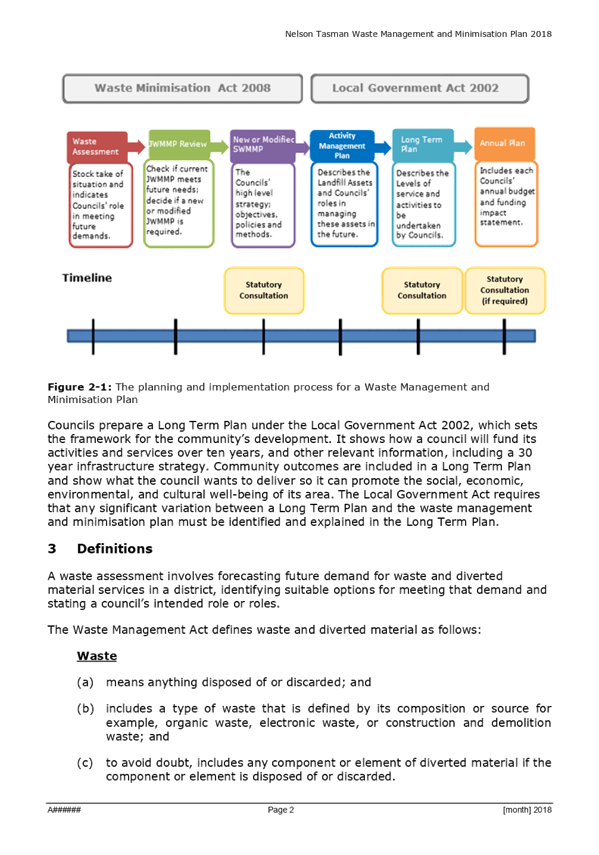
1. Purpose
of Report
1.1 To
update the Works and Infrastructure Committee on infrastructure projects for
the current financial year.
2. Recommendation
|
That the Works and Infrastructure
Committee
Receives the Chairperson's
Report (R9417).
|
2. Discussion
2.1 I
wanted to bring to the Committee’s attention a summary relating to the
infrastructure portfolio for the current financial year.
Projects that have been
completed
· Bronte Street
footpath extension – construction of 3m wide footpath and associated
retaining wall adjacent to St Joseph’s School;
· Footpath
Improvements – minor works to install pedestrian dropped crossing points
in Kawai Street and Alfred Street;
· ANZAC Park
pedestrian refuge – pedestrian refuge in Rutherford Street adjacent to
ANZAC Park;
· Seismic Reservoir
upgrades – installed seismic valves to existing reservoir pipework;
· Orphanage Creek
culvert upgrade – widened the existing culvert at Saxton Road;
· Manhole
rehabilitation works – minor repair works to the interior of existing
manholes;
· Jenner Road sewer
upgrade – relined the existing public sewer within private properties
adjacent to Jenner Road;
· York Stream
upgrade – installed large diameter stormwater pipes and a new intake
structure from Tipahi Street to Bishopdale;
· Maire Stream
erosion repairs – installed rock protection around an existing trunk
watermain that had been exposed by the 2011 extreme rain event;
· Days Track slip
remediation – reconstructed the Days Track pedestrian access from Moana
Avenue to Grenville Terrace;
· Saxton Creek
upgrade – completed stage 3 of the upgrade of Saxton Creek;
· Brook Stream fish
passage – installed two fish passage structures to trial their
effectiveness within the Brook Stream stormwater channel;
· Main Road Stoke
pedestrian refuge - a new pedestrian refuge within Main Road Stoke adjacent to
the Greenmeadows Centre work site;
· Hilliard, Mules
and Suter watermain renewals - upgrade of three aged watermains;
· Hampden Street
East/Little Go Stream Flood Protection – new intake structure in Allan
Street;
· Resurfacing of
Waimea Road and Richardson Street;
· Resurfacing and
pavement rehabilitation of Wildman Avenue/Vickerman Street Roundabout;
· Pavement
rehabilitation and single lane resurfacing of Saxton Road between Main Road
Stoke and Nayland Road;
· Sealing of cracked
pavement surfaces on various city streets;
· Detailed
structural inspection of road retaining walls (undertaken every 5-6 years);
· Stansell Ave slip
repair – retaining wall to support an existing footpath opposite no.46
Stansell Avenue;
· Oldham Creek
bridge replacement - replacement of bridge including road alignment and
footpath improvements;
· Natalie Street and
Joyce Place walkway connection;
· Rock wall
protection reinstatement following storm damage at Akersten Street;
· Repair of Early
Settlers Memorial platform and Rocks Road bollards and chains following
February storms;
· Seafield Terrace
reinstatement and realignment of the existing sewer following February storms;
· Cliff palisade
retaining wall improvements to strengthen existing retaining structure;
· Trafalgar Park
arched footbridge (over Maitai) – installation of hybrid cathodic
protection.
Projects
that are underway or about to commence on site
· Neale Park Sewer
Pump Station Upgrade – currently underway and expected to be completed in
December 2018;
· Nile Street
Stormwater Upgrade – currently underway and expected to be completed in
October 2018;
· Brook MTB Hub -
currently underway and expected to be completed in December 2018;
· Brooklands
watermain renewal – currently underway and stage 1 is expected to be
completed in June 2018;
· Footpath
Improvements – various areas, currently underway and expected to be
completed in June 2018;
· Asphalt surface
crack sealing programme for high volume roads – various areas, currently
underway and expected to be completed in June 2018;
· Seafarers Memorial
and Friendship Walkway repairs following February storms - currently underway
and expected to be completed in July 2018;
· Install of new
CCTV cameras - various areas, currently underway and will be ongoing;
· Cable Bay Road
debris catch fence - currently underway and expected to be completed in June
2018;
· Nelson Waste Water
Treatment Plant sludge removal - currently underway and expected to be
completed in September 2019.
Projects that have been
tendered
· Civic House Floor
1 Upgrade;
· Professional
Services Panel;
· Saltwater Creek
Bridge;
· Orphanage
Creek/Sunningdale Bank Reinstatement;
· Champion Link
Road.
Stuart
Walker
Chairperson
Attachments
Nil
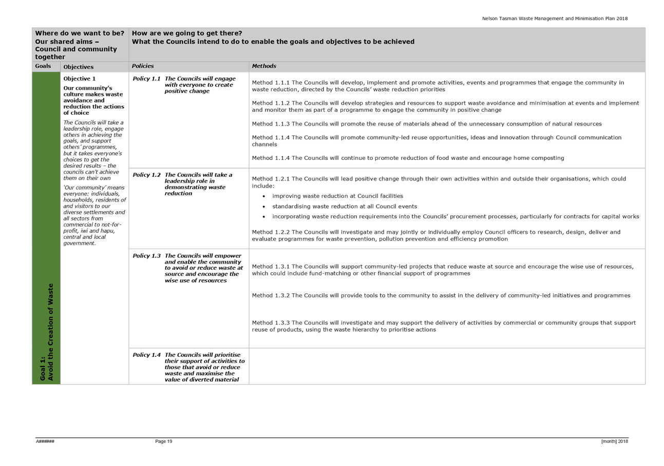
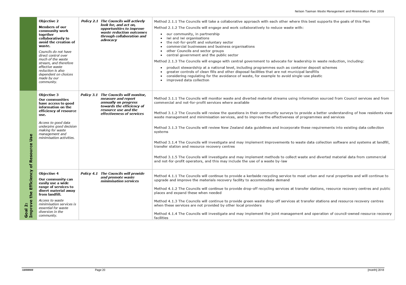
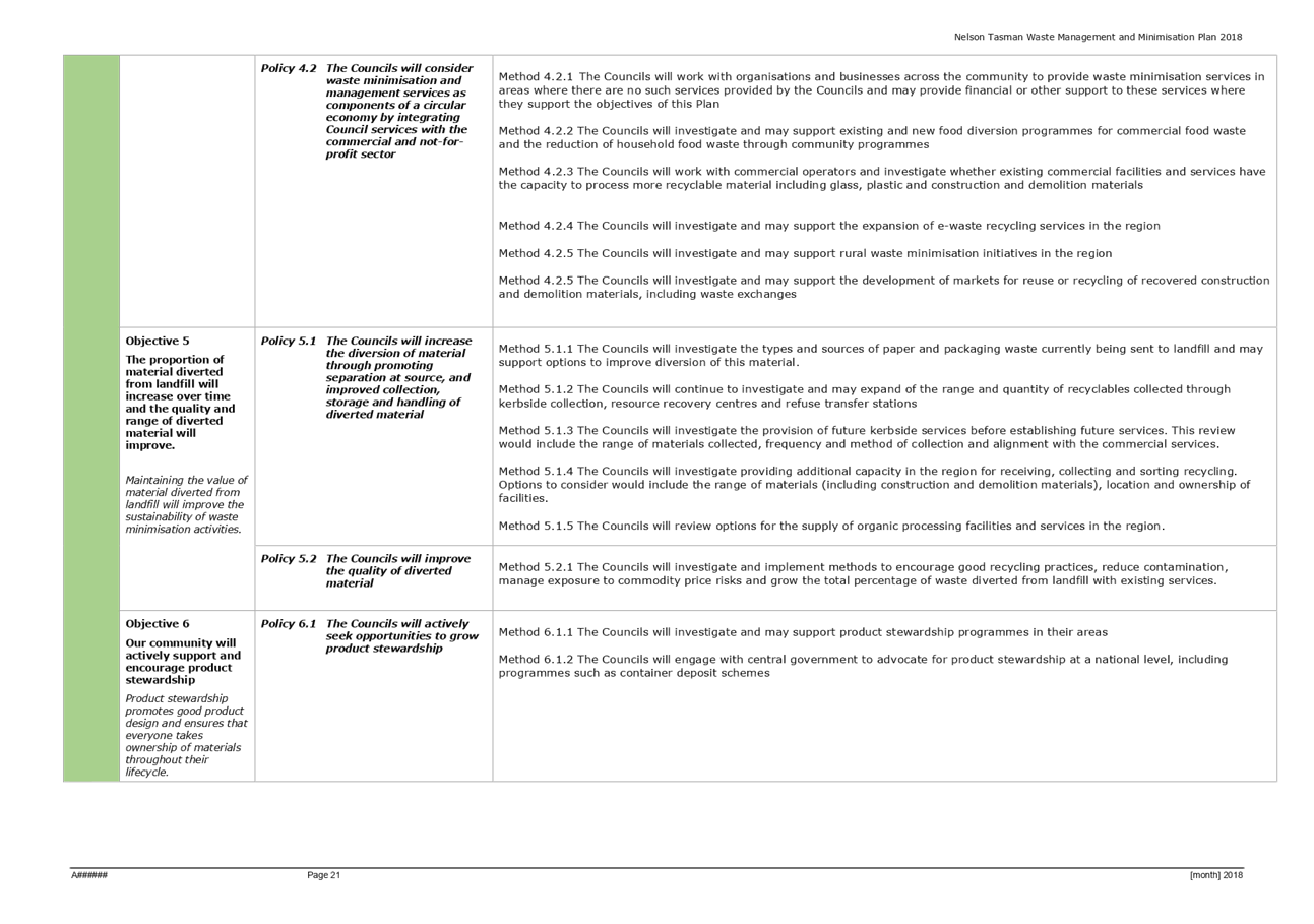
Item 7: Joint Waste
Management and Minimisation Plan
|

|
Works and Infrastructure Committee
28 June 2018
|
REPORT R8965
Joint
Waste Management and Minimisation Plan
1. Purpose
of Report
1.1 To
consider the Draft Nelson Tasman Joint Waste Management and Minimisation Plan
(JWMMP) developed by the Joint Nelson Tasman Waste Working Party (Working
Party) and recommend that Council approves the JWMMP for public consultation.
1.2 To
consider and recommend that Council approves the Statement of Proposal (SOP)
developed by the Working Party for public consultation.
2. Recommendation
|
That the Works and Infrastructure
Committee
Receives the report Joint Waste
Management and Minimisation Plan (R8965)
and its attachments (A1831374, A1987259 and A1987256); and
Approves the Statement of
Proposal (A1987256 of report R8965) and the draft Joint Nelson Tasman Waste
Management and Minimisation Plan (A1987259 of report R8965) for the purposes
of community consultation subject to an equivalent resolution being passed by
the Tasman District Council; and
Delegates authority to approve any minor changes to the
draft Joint Nelson Tasman Waste Management and Minimisation Plan (A1987259 of
report R8965) and Statement of Proposal (A1987256 of report R8965) to the
Chair (Councillor Kit Maling – Tasman District Council) and Deputy
Chair (Councillor Stuart Walker – Nelson City Council) of the Joint
Nelson Tasman Waste Working Party.
|
Recommendation to Council
|
That the Council
Approves
the draft Joint Waste Management and Minimisation Plan (A1987259 of report
R8965) and the Statement of Proposal (A1987256 of report R8965) that will
allow the Special Consultative Procedure to commence.
|
3. Background
3.1 Council
in December 2017 resolved as follows:
Approves
the formation of a Joint Nelson City Council/Tasman District Council Working
Party to advise both Councils on the review of the Nelson Tasman Joint Waste
Management and Minimisation Plan 2012, subject to a reciprocal agreement by
Tasman District Council; and
Approves
the Draft Terms of Reference as amended to reflect the removal of the words
‘co-opt and change of quorum to five, including two councillors from each
council (A1831374); and
Appoints
Councillors Walker, Barker and Lawrey as Nelson City Council members of the
Joint Council Waste Working Party; and
Notes that the
Joint Council Waste Working Party will report back to this Council’s
Works and Infrastructure Committee to ensure that the Joint Waste Management
and Minimisation Plan can be adopted by April 2018.
3.2 The
Working Party’s Terms of Reference (refer to Attachment 1) includes the
preparation of an amended JWMMP and submission of the Plan to the two Councils
for consideration as the basis for consultation.
3.3 The
original date set to bring this item back to both Councils by April 2018 could
not be met due to the time involved in getting all parties from both Councils
together for several workshops and meetings.
3.4 Council
has not been able to meet the statutory requirement to review and adopt a waste
management and minimisation plan within the period of 6 years. There was
general consensus by the Working Group that working through the Plan was more
important than rushing the task to meet the statutory requirement. The Working
Party met on four occasions and agreed at their meeting on the 11 May 2018 to
adopt the Draft JWMMP and for it to be presented to each Council for approval
as the version to go out to wider consultation.
3.5 The
risk to both Councils of not achieving this statutory timeframe is the
potential loss of revenue (waste levy disbursements) from the Ministry for the
Environment (MfE), of around $55,000. However, advice received from the MfE
indicates that there will be no sanction on Council as long as the Plan has
been reviewed.
3.6 Subject
to approval of the Draft JWMMP by the two Councils, consultation is scheduled
to commence in August 2018, after which the Working Group as per their Terms of
Reference will hear submissions, hold hearings and consider submissions on
behalf of the two Councils.
4. Discussion
4.1 The
proposed SOP and Draft JWMMP are required to be approved by both Councils prior
to consultation commencing. The current Long Term Plans of both Councils were developed
within the statutory requirement of the current JWMMP.
4.2 The
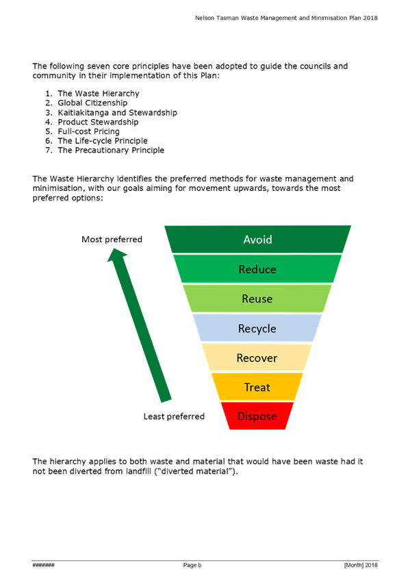
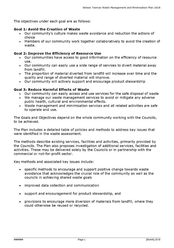
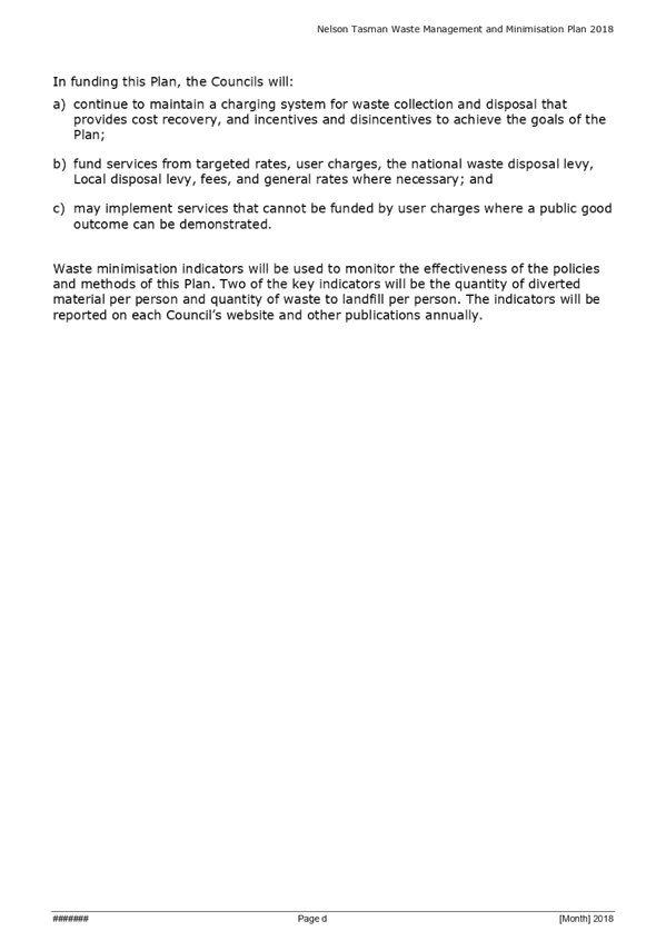
Draft JWMMP provides a policy framework for waste management and minimisation
activities and contains a list of solid waste management options available to
the community and Councils through which the Councils can develop and implement
projects/programmes to achieve improved solid waste management outcomes.
However, the Plan does not place any financial obligations on either Council
and will not impact on the current LTP budget.
5. Key
changes in the Draft JWMMP
5.1 The
Working Party concluded that the existing JWMMP is broadly fit for purpose and
mainly focussed on articulating the concept that the community shares the
responsibility for waste minimisation with the Councils.
6. Options
6.1 The
Council has two options with respect to the Draft JWMMP and SOP as detailed
below:
· Option 1 - Endorse
the recommendation (with minor amendments) from the Working Party that the
Draft JWMMP is suitable to inform the SOP for consultation - preferred option;
or
· Option 2 - Not
accept the recommendation of the Working Party and make recommendations to the
Working Party to amend the SOP and/or Draft JWMMP.
|
Option 1: Accept that the
Draft JWMMP with minor amendments be used to inform the Special Consultative
Procedure.
|
|
Advantages
|
· Provides
consistent policy framework relating to solid waste management and
minimisation for the Regional Landfill Business Unit and the Nelson Tasman
Communities.
|
|
Risks and Disadvantages
|
· None
|
|
Option 2: Not accept that the
Draft JWMMP be used.
|
|
Advantages
|
· None.
|
|
Risks and Disadvantages
|
· Amendments
to the SOP and Draft JWMMP will delay the consultation, which will in turn
delay the adoption of the JWMMP.
· Potential
loss of payment from the MfE.
|
7. Conclusion
7.1 The
Council has a statutory obligation to review the Waste Management and
Minimisation Plan at least every six years.
7.2 The
Draft JWMMP and SOP have been developed and approved by the Joint Working Party
and approval is sought from the Committee and Council to commence consultation.
Johan
Thiart
Senior
Asset Engineer - Solid Waste
Attachments
Attachment 1: Joint
Waste Working Party: Terms of Reference A1831374 ⇩
Attachment 2: Draft
Joint Waste Management and Minimisation Plan A1987259 ⇩
Attachment 3: Statement
of Proposal - Joint Waste Management and Minimisation Plan A1987256 ⇩
|
Important considerations for decision making
|
|
1. Fit
with Purpose of Local Government
The JWMMP is a key strategic document for waste
management and minimisation in the region. It influences the management of
Council services and provision of long-term infrastructure.
|
|
2. Consistency
with Community Outcomes and Council Policy
The development of the JWMMP contributes to the
community outcome “Our infrastructure is efficient, cost effective and
meets current and future needs”. It is a document that will guide waste
management decisions by the Council over the next six years.
|
|
3. Risk
The Waste Minimisation Act 2008 requires the Council
to review the JWMMP at an interval of no less than six years. The risk that
the MfE might delay the payment of Waste Levy disbursements to Council until
the new JWMMP is adopted is assessed to be low as confirmation has been
received from the MfE that it is unlikely that payments from them will be
withheld.
|
|
4. Financial
impact
Decisions made in the review and amendment of the
JWMMP have no direct financial or budgetary implications for the Council in
the medium to long term, but these impacts will be ultimately determined by
the Council through future Long Term Plan and Annual Plan processes.
|
|
5. Degree
of significance and level of engagement
Waste management and minimisation policy affects
most people in our region and commercial operators and the wider community
have a significant interest in this matter. This matter is of medium
importance and a Special Consultative Procedure (SCP) in accordance with
Section 83 of the Local Government Act 2002 is planned.
|
|
6. Inclusion
of Māori in the decision making process
Iwi have been kept up to date and were invited to
take part in the process of developing the Draft JWMMP. The current Draft,
once approved, will be shared by way of separate meetings with Iwi and their
comments will be considered by the Working Party.
|
|
7. Delegations
The Works and Infrastructure
Committee areas of responsibility includes:
“Solid Waste, including landfill and transfer stations, recycling
and waste minimisation”.
A Nelson Tasman Joint Waste Working Party has been
set up and their Terms of Reference include for reviewing the Draft JWMMP,
hearing and considering submission and recommending a final JWMMP to both
Council’s for adoption. The Working Party has no powers to decide.
Their Powers to recommend include:
“Recommending the adoption of an amended JWMMP for Nelson City
Council and Tasman District Council”
The Council has approved that the Draft JWMMP be
considered by the Works and Infrastructure Committee first before coming back
to Council.
|
Item
7: Joint Waste Management and Minimisation Plan: Attachment 1
Item
7: Joint Waste Management and Minimisation Plan: Attachment 2


Item
7: Joint Waste Management and Minimisation Plan: Attachment 3

Item 8: Recycling
- Effect of International Markets
|

|
Works and Infrastructure Committee
28 June 2018
|
REPORT R9280
Recycling
- Effect of International Markets
1. Purpose
of Report
1.1 To
provide the Committee with an update on the current status of recycling as a
result of changes in international commodity markets.
1.2 To
agree a way forward with respect to how recycling is progressed for the 2018/19
financial year.
2. Summary
2.1 Nelsonians
have a very high commitment to recycling evidenced by the 40% increase in
recycling since the new wheelie bins were introduced.
2.2 China,
one of the largest markets for recyclables has made the decision, through their
National Sword initiative, not to accept recycling and have
restricted all licences. This has resulted in a sudden and steep drop in
commodity prices for fibre and certain plastics.
2.3 This
drop in commodity price is having an effect both nationally and internationally
and is an issue that is affecting all local authorities in New Zealand, with
the issue being commented on by the Minister of Conservation. Some Councils in
Australia have already taken steps to divert all recycling to landfill.
2.4 Nelmac
has been affected by the commodity down-turn and has signalled to Council that
they will be seeking relief, as allowed for under their contract with Nelson
City Council (NCC).
2.5 The
contract with Nelmac states that responsibility will become the
Principal’s if the commodity price drops for any one commodity by 70% for
12 months or more. The 70% trigger level has been reached for fibre (January
2018) and PET Mixed plastics (April 2018) and will remain Nelmac’s
responsibility for 12 months until January 2019 and April 2019 respectively.
2.6 When
Council accepts responsibility as Principal for those two commodities, the
additional costs will be able to be covered through the current reserves in the
Solid Waste Account.
3. Recommendation
|
That the Works and Infrastructure
Committee
Receives the report Recycling
- Effect of International Markets (R9280); and
Agrees
to continue with recycling in Nelson recognising the strong commitment from
Nelsonians; and
Agrees
to accept the costs resulting from the global drop in commodity prices, for
the 2018/19 financial year at an estimated cost of between $88,500 and
$94,500, funded from current reserves in the Solid Waste account; and
Requests
a further follow-up report to a future Works and Infrastructure Committee in
early 2019 advising of the longer term future of recycling.
|
Recommendation to Council
|
That the Council
Approves
the funding resulting from the global drop in commodity prices for the
2018/19 financial year at an estimated cost of between $88,500 and $94,500,
funded from current reserves in the Solid Waste account.
|
4. Background
4.1 Council
entered into a contract with Nelmac in late 2004 for “Contract 2906: The
collection and processing of recyclable materials and the operation of the
re-use shop”. That contract is valued at $951,000/annum (and includes
wheelie bin collection).
4.2 Recyclables
collected by Nelmac and their markets until March 2016 are as follows:
· Fibre (paper and
cardboard) to Full Circle;
· Aluminium/steel to
Nelson Metals/Sims Metals;
· HDPE Plastics (milk
bottles) to Comspec;
· PET Mixed Plastics
(water/carbonated bottles) to Full Circle;
4.3 Smart
Environmental Limited (SEL) in collaboration with the Tasman District Council
(TDC) built a Materials Recycling Facility (MRF) in Richmond to process
recyclables. Nelmac have taken all recyclables collected at kerbside (glass,
plastics, aluminium/steel and fibre) to SEL since March 2016.
4.4 Since
the introduction of wheelie bins (around October 2016), recycling has seen a
40% growth, with fibre making up around 80% of all recycling collected in
Nelson.
4.5 China
has traditionally been the single largest purchaser of recyclable materials
with NZ sending around 15 Million kilograms to China every year. In mid-2017
China advised the world that it would no longer receive the rest of the
world’s recyclables. That initiative, known as National Sword,
came into effect in January 2018 and has resulted in the restriction of import
licenses.
4.6 The
restriction of import licenses has seen global commodity prices plummet for
some commodities especially fibre and PET Mixed plastics. SEL have advised
Nelmac that they are working hard to establish new markets (both locally and
overseas), and whilst Nelmac are themselves actively seeking other markets the
message is the same for them – everyone is struggling and competing for
the same markets.
4.7 The
markets for glass and HDPE plastics are unaffected by National Sword for
our region, as those markets remain within New Zealand with glass going to
Auckland and HDPE plastic going to Christchurch.
4.8 Whilst
some material has been diverted to Indonesia, Thailand and Vietnam, SEL advise
that they are seeking alternative markets in the Philippines, Malaysia and
India. They further note that they will continue to sell product even at low
prices and if needs be, if markets cannot be found, will be looking at storing
material. SEL are continuing to take product and have not signalled at this
stage any intention to stop taking product.
4.9 They
have also asked Nelmac to potentially store product - however the ability of
Nelmac to store product, especially fibre (at an average of around 129
tonnes/month and up to 160 tonnes/month) is not feasible. The area required to
stockpile this volume of fibre every month (for potentially up to 12 months)
would require covered storage (as fibre has no value once it is wet) of around
1,700m2.
4.10 In
addition, the storage of recyclables (plastic and fibre) poses a health and
safety risk. As recently as last month a fire broke out at a MRF facility in
Thames that resulted in the destruction of a warehouse and around 150 tonnes of
stored plastic and fibre with another 100 tonnes having to go to landfill due
to fire damage.
4.11 SEL
have reported through various media sources that they are stockpiling paper and
plastic (on behalf of Council’s with whom they have contracts) since the
ban, with around 3,000 to 4,000 tonnes stockpiled around the country. Research
by officers’ also show that most, if not all Councils, are currently
stockpiling recycling.
4.12 The
Minister of Conservation has noted that the Government’s long-term effort
is focused on improving onshore capacity for recyclable materials but that this
will take time. A task force has been set up to look at how to deal with this
growing mountain of recyclable waste in New Zealand and will be led by the
Ministry for the Environment.
Current contract
4.13 The
current recycling contract with Nelmac includes a clause that caters for a drop
in commodity prices. Clause 3.2.2 - National and International Recyclables
markets notes:
“That
in the event of a national or international collapse in any of the specified
recyclable products the financial consequences of such a collapse may, at the
request of the Contractor, become the responsibility of the Principal. In the
circumstances the Contractor will provide the information on all specified
recyclable product values since commencement of the contract. The Engineer will
then assess the impact of the collapse on the Contractor. The Principal,
Engineer and the Contractor shall then determine any necessary variation to the
contract. A market collapse in any one specified recyclable product, other than
glass, is defined as where the commodity price received by the contractor drops
by 70% or more from the prices as at 1 October 2004 for a period of 12 months
or longer.”
4.14 The
average tonnage/month per commodity is shown in the table below:
|
Commodity
|
Average
tonne/month
|
Percentage of
overall recycling
|
|
Fibre
|
129
|
77%
|
|
PET Clear
|
6
|
3.6%
|
|
PET Mixed
|
7
|
4.3%
|
|
HDPE
|
6
|
3.6%
|
|
Aluminium
|
1
|
0.9%
|
|
Steel
|
8
|
5%
|
|
Contamination
|
9
|
5.6%
|
5. Discussion
Commodity prices
5.1 Commodity
prices have steadily decreased since September 2017 as a result of National
Sword. The contract with Nelmac requires commodity prices to have
fallen by 70% for a period of 12 months as at 1 October 2004. Whilst the prices
for all commodities have fluctuated since 2004 when the contract commenced,
Nelmac have only been experiencing significant effects since September 2017.
The table below summarises that history.
|
Commodity
|
04/05
|
Sept 17
|
April 18
|
% drop since
Sept 17
|
70% Trigger
|
Date 70% threshold
reached
|
|
Fibre
|
$62/t
|
$122/t
|
$8/t
|
93%
|
$37/t
|
Jan 2018
|
|
PET Clear
|
$375/t
|
$321/t
|
$151/t
|
53%
|
$96/t
|
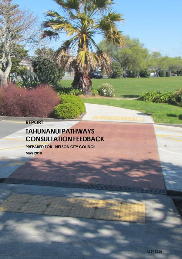
Not yet reached
|
|
PET Mixed
|
$75/t
|
$31/t
|
$0/t
|
100%
|
$9/t
|
April 2018
|
5.2 The
monthly drop in commodity prices since September 2017 and the 70% trigger level
is shown in the following table:
|
Month
|
PET Mixed
|
Fibre
|
PET Clear
|
|
Sept 2017
|
$31
|
$122
|
$321
|
|
Oct 2017
|
$22
|
$102
|
$321
|
|
Nov 2017
|
$12
|
$102
|
$162
|
|
Dec 2017
|
$12
|
$97
|
$162
|
|
Jan 2018
|
$12
|
$37
|
$162
|
|
Feb 2018
|
$12
|
$37
|
$162
|
|
March 2018
|
$12
|
$8
|
$162
|
|
April 2018
|
$0
|
$8
|
$151
|
5.3 From
the two tables, it is clear that commodity prices have dramatically fallen over
the last eight months as a result of National Sword. The industry
view is not positive, with the outlook unlikely to change in the foreseeable
future.
5.4 Currently
the contractual threshold of 70% has been reached as follows and Nelmac has
written to Council giving notice of their intent to seek relief, as allowed for
under the contract:
5.4.1 Fibre
- Jan 2018 and will remain Nelmac’s responsibility until Jan 2019;
5.4.2 PET
Mixed - April 2018 and will remain Nelmac’s responsibility until April
2019;
5.4.3 PET
Clear – trigger not yet reached.
5.5 For
the 2018/19 financial year, Council will be faced with the cost for fibre for
six months and for PET Mixed plastics for two months. At the current prices,
there would be no financial implication to Council for PET Clear during
2018/19.
6. Financial
considerations for 2018/19
Cost to Council for 2018/19
6.1 The
cost to Council for the 2018/19 financial year, for fibre and PET Mixed is as
follows:
|
Commodity
|
Current prices
|
Lower end prices
|
|
Fibre
|
@ $8/t
|
@ $0/t
|
|
6 months
|
$88,000
|
$94,000
|
|
PET Mixed
|
@ $0/t
|
@ $0/t
|
|
2 months
|
$500
|
$500
|
|
TOTAL
|
$88,500
|
$94,500
|
6.2 Council
currently has reserves in the Solid Waste Activity amounting to $570,000 (as at
30 June 2017) that could be used to offset the current commodity price
down-turn for the 2018/19 financial year.
Cost to landfill for 2018/19
6.3 The
cost to take recycling to landfill will attract a charge of $119/tonne
(excluding GST) and will depend on the volumes taken to landfill. The table
below details the indicative costs to take recycling to landfill:
|
Commodity
|
Volume/month
(average)
|
Total
|
Comment
|
|
Fibre
|
129 tonne
|
$92,000
|
For 6 months
|
|
PET Mixed
|
7 tonne
|
$ 2,000
|
For 2 months
|
|
TOTAL
|
$94,000
|
|
7. Options
7.1 Council
has two options as detailed in item 7.2 below. These two options are based on
the assumption that:
7.1.1 Recycling
will continue in Nelson for 2018/19 – officers are of the view that it is
too soon to make any decision to consider stopping recycling as this would
undermine the excellent recycling ethos within Nelson; and
7.1.2 Storing
of recycling product by Nelmac is not viable, as the covered area needed
(particularly for fibre) is large and would cost in the region of $105,000/year
for a lease, $40,000 to $50,000 in transport costs/double handling and would
still pose a fire and safety risk and have implications on insurance.
7.2 The
two options are:
7.2.1 Option
1 – Continue to recycle with Council accepting costs for 2018/19 (6
months for fibre and 2 months for PET Mixed).
7.2.2 Option
2 – Continue to recycle and take to landfill until commodity prices
stabilise.
|
Option
1: Continue to recycle with Council accepting costs for
2018/19
|
|
Advantages
|
· Low
reputational risk.
· Can be
covered from Solid Waste reserves.
· Recycling
momentum maintained.
· No
cost to ratepayer.
|
|
Risks and Disadvantages
|
· Lowers
solid waste reserves.
|
|
Option 2: Continue to recycle
and take to landfill
|
|
Advantages
|
· Can
be covered from Solid Waste reserves.
· No
cost to ratepayer
|
|
Risks and Disadvantages
|
· High
reputational risk.
· Undermines
recycling ethos.
· Greater
cost than (or on a par) with option 1
· Lowers
solid waste reserves
|
8. Conclusion
8.1 Commodity
prices have fallen dramatically for fibre and certain plastics and continue to
be low as a result of National Sword.
8.2 Nelmac
has requested relief, as allowed for under the contract, to cater for low
commodity prices and their mounting losses.
8.3 Council
needs to make a decision as to how they wish to proceed with recycling for
2018/19 and officers have provided options. Officers support Council accepting
the drop in commodity price and continuing to recycle on the basis that the
impact is less than diverting recycling to landfill – and that this be
funded from the reserves in the Solid Waste account.
Alec
Louverdis
Group
Manager Infrastructure
Attachments
Nil
|
Important
considerations for decision making
|
|
1. Fit
with Purpose of Local Government
Recycling is a key Government initiative to address
sustainability in a cost effective manner for households and businesses.
|
|
2. Consistency
with Community Outcomes and Council Policy
Recycling contributes to the following community
outcome:
“Our infrastructure is efficient, cost
effective and meets current and future needs”; “Our unique
natural environment is healthy and protected”; “Our urban and
rural environments are people-friendly, well planned and sustainably
managed” and “Our Council provides leadership and a regional
perspective”.
|
|
3. Risk
How Council deals with the current situation is
critical to the perceptions of the general public on the back of the
excellent work the community has done to embrace and increase recycling. The
risk of reputational risk to Council if recycling is discontinued or if
recycling is collected but taken to landfill is very high.
|
|
4. Financial
impact
The long-term financial impact to Council is
potential high should commodity prices remain low. However, this can be
offset by the reserves in the Solid Waste Activity for the 2018/19 year,
which will allow officers time to assess the commodity markets.
In the interim Nelmac’s profit and therefore
funding dividend to Council will be impacted by the loss they will carry for
12 months.
|
|
5. Degree
of significance and level of engagement
This matter is of medium significance. Council will
however need to clearly communicate their decision to their ratepayers.
|
|
6. Inclusion
of Māori in the decision making process
Maori have not been consulted on with
respect to this report.
|
|
7. Delegations
The Works and Infrastructure
Committee areas of responsibility includes:
“Solid Waste, including landfill and transfer stations, recycling
and waste minimisation”.
|
Item 9: Tahunanui Cycle
Network - Preferred Option
|

|
Works and Infrastructure Committee
28 June 2018
|
REPORT R8979
Tahunanui
Cycle Network - Preferred Option
1. Purpose
of Report
1.1 To
approve a preferred cycle facility route from Annesbrook Roundabout to Beach
Road to allow targeted consultation, detailed design and construction to
proceed.
2. Summary
2.1 Council
resolved in August 2017 to establish the Tahunanui Cycle Network Advisory Group
(Group) consisting of key stakeholders, councillors, community representatives
and Council officers to determine a preferred route for the Tahunanui Cycle
Network.
2.2 The
Group consulted with the Tahunanui community, schools, specific community
groups and cycling advocate groups to better understand how people currently
travel around Tahunanui and what improvements they would like to see. The
outcome from this consultation has identified a preferred option as a priority
as well as an overall programme of works for improving cycling facilities
within Tahunanui.
2.3 As
part of the Regional Land Transport Plan (RLTP) and Long Term Plan (LTP)
deliberations, officers advised the Regional Transport Committee (RTC) that the
cost estimate for this preferred option, at $2.8M, was higher than that
provided in both the RLTP and LTP and made the recommendation to the RTC and
Council to increase the funding to ensure that both NZTA subsidy and/or Urban
Cycle Fund (UCF) funding was secured. This increase was approved by both the
RTC on the 11 May 2018 and Council on the 17 May 2018.
2.4 The
consultation also identified future works and linkages and officers advised the
RTC that this programme of works had as yet not been considered by the Works
and Infrastructure Committee and as a result had not been included in either
the LTP, RLTP or Transport Asset Management Plan (AMP). Should this Committee
approve the future works and linkages, officers propose to consult on these
suite of projects through an application to vary the RLTP in the new financial
year that will enable these projects to be considered in the National Land
Transport Programme and secure funding from the National Land Transport Fund.
Once that process has been completed, the projects, if signed off by the RTC
will be added to the Council’s work programme as part of the 2019/20
Annual Plan. This proposed variation to the RLTP will be co-ordinated with the
variation planned to include the three NZTA State Highway projects identified in
the Transport Agency Investment Proposal but not yet part of the current RLTP
– this work is the subject of a separate report to the Nelson Regional
Transport Committee.
2.5 The
preferred option will provide a high quality asset that will be safer and more appealing
for all active users and is able to provide significant benefits as a
stand-alone project if the remaining works programme is deferred or delayed.
3. Recommendation
|
That the Works and Infrastructure
Committee
Receives the report R8979 Tahunanui
Cycle Network - Preferred Option , and its attachments (A1948256, and
A1979013); and
Approves
as the top priority for progression to targeted consultation, detailed design
and construction Option 1: Route 1 – Annesbrook Roundabout to Beach
Road as detailed in Report R8979; and
Recommends the package of work as identified in Attachment 2
(A1979013 of Report R8979) to be considered in the next review of the
2021-2031 Transport Activity Management Plan and Council’s Long Term
Plan 2021-2031.
|
4. Background
4.1 The
Tahunanui cycleway project was approved by Council on 26 November 2015 as part
of the “Out and About“ Policy, with the specific aim of providing a
safe and efficient cycle route through Tahunanui for ‘interested but
concerned’ cyclists, school children and the local community.
4.2 This project along with two other
projects is part funded by Central Government’s Urban Cycle Fund (UCF)
and includes:
4.2.1 QEII
Drive and Haven Road Shared Path – Work on this project commenced in
February 2018, is programmed for completion in July 2018 and managed entirely
by NZTA.
4.2.2 Saltwater Creek Bridge - currently
out for tender, with agreement reached with NZTA to extend the UCF funding for
this project to the end of June 2019.
4.3 As reported by officers at the 11
May 2018 RLTP deliberations meeting, the form and status of the UCF under the
new Government is still unknown. The RTC and Council have however, as part of
their submission to the Draft GPS, noted their desire that the UCF funding continue
and officers await advice from Central Government and NZTA as to the future of
this fund.
4.4 Work
on a preferred option connecting the airport to Tahunanui Beach using Bolt Rd,
Green Street, Roto Street and Golf Road was debated by the Works and Infrastructure
Committee on 18 May 2017 and was subsequently not approved. It was considered
that the route did not serve the needs of the community as it did not link
directly to the Railway Reserve and to schools, and that a large portion of
Tahunanui, including the Tahunanui Hills area, was not adequately served.
4.5 Council
resolved on 10 August 2017, following a public forum presentation by members of
the Tahunanui community, as follows:
“That
an Advisory Group to include the Chair of the Works and Infrastructure
Committee, Councillor Lawrey, a representative of Bicycle Nelson Bays, a
representative of NZTA and officers; to move this project forward be set up;
and
That a final option for implementation will be presented to a
future Works and Infrastructure Committee for approval in March 2018”.
4.6 The
Group was set up and comprised:
· Councillor Walker
(Chair)
· Councillor Lawrey
· Bicycle Nelson
Bays (Chris Allison & Natalie Lacaze-Campbell)
· Tahunanui Business
Association (John Gilbertson)
· Tahunanui
Community Centre (Judy Robinson)
· Tahunanui Primary
School (Barbara Bowen)
· NZTA Urban
Cycleway Fund (Gerry Dance)
· NCC officers
5. Consultation
5.1 The
Group consulted with the members of the Tahunanui community, schools, various
community groups and cycle advocacy groups to better understand how they
currently travel around Tahunanui and what improvements they would like to see.
The aim of this consultation was to assist in developing an overall programme
of works for improving cycling facilities within Tahunanui and was seen as
important to provide an active travel network for the whole Tahunanui suburb,
including the Tahunanui Hills area.
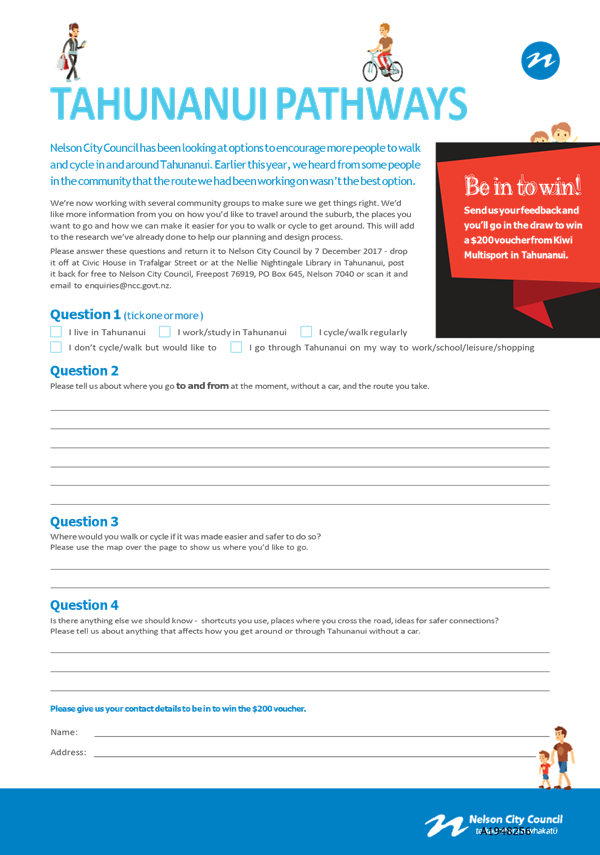
5.2 Public
consultation ran between 13 November and 7 December 2017. The consultation
material consisted of a paper and electronic feedback form and blank map to
gather information on the following:
· Where people
presently go to and from; and
· Their chosen
route; and
· What route they
would use if it was made safer to do so.
5.3 A
total of 220 submissions were received, comprising text and map responses which
have been collated and summarised on Attachment 1. The main feedback from the
consultation was that:
· The most popular
places people presently travel to and from is the Railway Reserve to Rocks
Road, followed by Tahunanui Beach to the Airport/Trent Drive.
· There was
difficulty in crossing Annesbrook Drive, Tahunanui Drive and other busy roads
in various locations.
5.4 A
number of the Group will be in attendance at the meeting to speak to this
project.
6. Programme
of Works
6.1 The
submissions were analysed by the Group and a programme of work developed which
included the development of a main spine route (Route 1) linking Annesbrook
Roundabout to Beach Road, suitable crossing points on State Highway 6, a route
to the airport and secondary routes linking to Route 1.
6.2 The
Group determined the priorities based on the outcome from the consultation,
with the highest priority being Route 1. This route represents the main spine
for Tahunanui and provides a safer link from Tahunanui beach to the Railway
Reserve and will provide a viable and appealing alternative to the use of State
Highway 6 Tahunanui Drive for active transport modes. This route also directly
links up with Stoke schools and the Tahunanui School and Community Centre.
6.3 Route
1 is able to operate independently as a stand-alone project if the remaining
works programme is deferred or delayed.
6.4 NZTA
is supportive of Route 1, in particular, the portion of the route along Annesbrook Drive as this portion of the route will have
minimal impact on the existing traffic lanes as the cycle facility will occupy
road berm and the existing footpath.
6.5 The
full programme of works (refer to Attachment 2) is expected to deliver the
desired benefits, and capture active travel customers from a wider area and
cater for the whole community and schools. The programme of works with
priorities is detailed in Figure 1 below.
7. Facility
Type for Route 1
7.1 Route
1 (yellow route in figure 1 below) is a new cycling facility from Annesbrook
Roundabout to Beach Road via Annesbrook Drive, Parkers Road, Muritai Street,
Waikare Street and will consist of two ‘facility types’ as
determined by the Group, best practice guidelines and detailed multi criteria
analysis. These facility types are shown below.
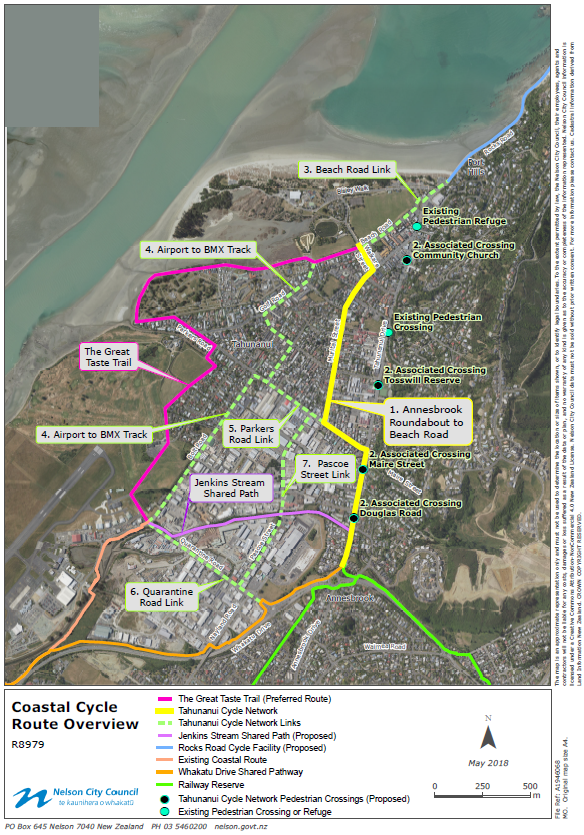
Figure 1 – Coastal Cycle Route Overview
|
Facility Type
|
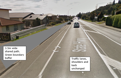
Off Road Shared Path
|
|
Proposed Roads
|
SH6 Annesbrook Drive and some of Parkers Road
|
|
Description
|
A 3.5m wide off-road shared path
is proposed for SH6 Annesbrook Drive (610m long) to the crossing point on
Parkers Road (50m long). A single wide path to be used by both cyclists and
pedestrians. On Annesbrook Drive existing parking, sealed shoulders and
traffic lanes remain unchanged on both sides.
|
|
Layout
|
|
|
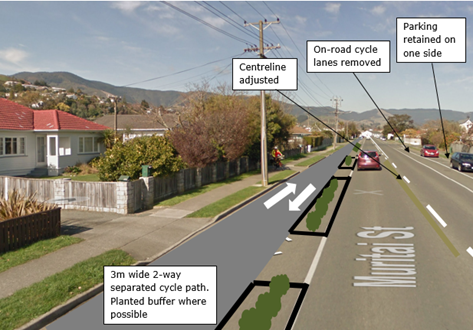
Facility Type
|
Two-way Separated Cycle Path
|
|
Proposed Roads
|
Some of Parkers Road, Muritai Street and Waikare Street
|
|
Description
|
A 3m wide two-way separated
cycle path is proposed from the crossing point on Parkers Road (190m long),
along Muritai Street (840m long) and along Waikare Street (130m long). The
cycle path is to be on one side of the road, protected from traffic by raised
concrete separators, planted wherever possible. Separate footpaths are
retained on both sides. Parking is retained on one side only. On-road cycle
lanes on Muritai Street are removed.
|
|
Layout
|
|
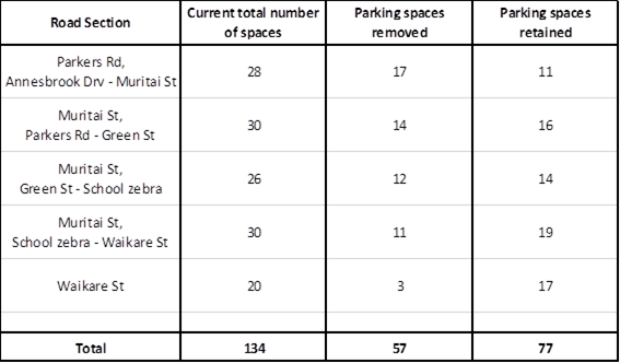
Effect on parking
Route 1 will result in a total
estimated loss of 57 car parking spaces as detailed below.
7.1 There
is demand for parking by local business employees during work days on Parkers
Road and the west end of Muritai Street, but low level demand by residents at
all times in all areas. Loss of parking is never popular, but it is nonetheless
a consequence and outcome of the preferred option selected by the Group.
7.2 It
is hoped that due to the inclusive and collaborative approach taken through the
consultation process that it will be possible to win over potential public
negative opinions in favour of community benefits, particularly the ability for
children to safely get to school using active travel modes. This does however
have the risk of a delay in the project implementation as officers commence
targeted consultation.
7.3 It
is the intention for officers to work with businesses in the area as part of
their Travel Management Plan initiative (due to commence in July 2018) and
officers will be looking to assist affected businesses to assist in developing
work-place travel plans to reduce demand for on-street parking in the vicinity
of Parkers Road.
8. Finances
8.1 Following
the recent RLTP and LTP deliberations, a revised budget of $2.8M was included
in the budgets (to ensure that NZTA subsidy was secured) for Route 1, with the
proposed phasing as follows:
|
Financial
year
|
2018/19
|
2019/20
|
2020/21
|
Total
|
|
Amount
|
$200,000
|
$800,000
|
$1,8M
|
$2,8M
|
8.2 The original funding split for this project was a 1/3 each
from Council, NZTA and UCF. The UCF funding was required to be spent by 2018
and NZTA have recently agreed to extend that to June 2019. That timeframe would
not align with the current anticipated timeline to complete this work (June
2021).
8.3 Officers are still hopeful that the UCF will continue in
some form and that approval will be granted to complete this project beyond
2019. However, should the UCF fund not continue, then Council’s share
will increase from 33% to 50%.
8.4 NZTA, which is part of the Group has indicated strong
support for this preferred route and are also very supportive of the
portion of the route adjacent to SH6 Annesbrook Drive
and has indicated that this portion of the project may be eligible for full
funding by NZTA as it is contained within the State Highway corridor.
8.5 It
is proposed to include the remaining priorities within Attachment 2 (priorities
2 to 7) in the RLTP as a variation in the new financial year and once approved
included in the 2019/20 Annual Plan. The estimated total cost for the future
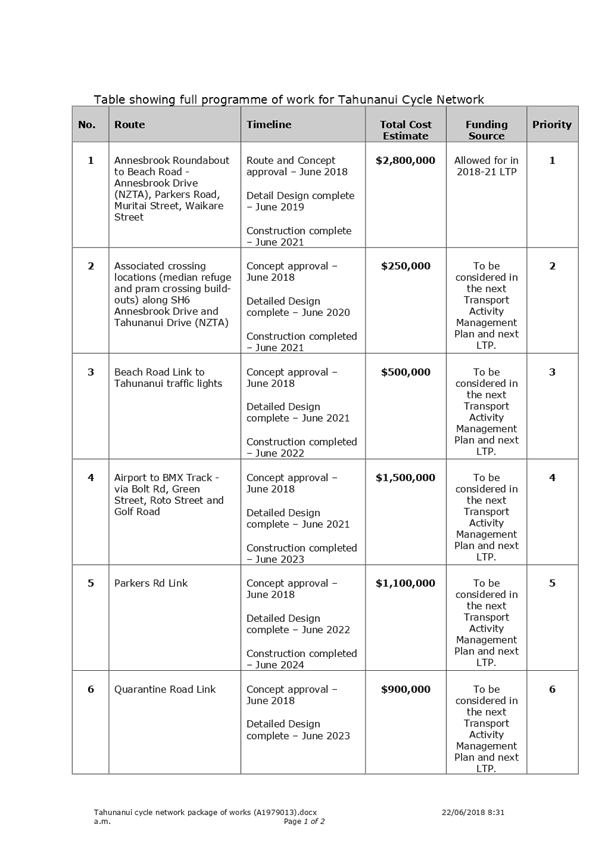
priorities works is $5,500,000 (refer to Attachment 2 for detail).
9. Options
9.1 The
committee has three options to consider as part of this report:
9.1.1 Option
1 - Approve the preferred option from the Group; or
9.1.2 Option
2 - Not approve the preferred option from the Group; or
9.1.3 Option
3 – Do minimum.
|
Option
1: Route 1 – Annesbrook Roundabout to Beach Road
|
|
Scope
|
A 3.5m wide
off-road shared path is proposed for Annesbrook Drive (610m long) to the
crossing point on Parkers Road (50m long).
A 3m wide
two-way separated cycle path is proposed from the crossing point on Parkers
Road (190m long), along Muritai Street (840m long) and along Waikare Street
(130m long).
|
|
Estimated Cost
|
$2,800,000 -
NCC share either $933,000 (1/3,1/3,1/3 split) or $1,400,000 (50/50 split)
|
|
Benefits (from Business
Case)
|
· Increase
in number of recreational/commuter cyclists using route
· Reduction
in vehicle movements
· Increase
in number of students cycling to school
· Decrease
in cycle crash numbers in Tahunanui
|
|
Benefit/Cost Ratio
|
1.4
|
|
Advantages
|
· Provides
a convenient, high quality, appealing and connected route for interested but
concerned cyclists and school children between Annesbrook Roundabout and
Tahunanui Beach.
· Muritai
Street and Waikare Street will benefit from reduced traffic speeds and
improved aesthetics and amenity through increased vegetation and softening of
the existing wide road environment.
· Provides
separation between vehicles & cyclists along the whole route (except at
road crossing points), and separation between cyclists & pedestrians
along Muritai and Waikare Street.
· Issues
with visibility at accesses and intersections alleviated on separated two-way
facility.
· This
route is not subject to concerns over future airport development plans.
· Fulfils
community and stakeholder expectations that a facility will be constructed
promptly after completion of the December 2017 community engagement phase and
that the facility will potentially be followed by a comprehensive connected
network.
|
|
Risks and Disadvantages
|
· Total
parking loss estimate 57 spaces. Parking loss on Parkers Rd (17 spaces)
and Waikare Street (3 spaces). Parking removed for one whole side of the
affected part of Muritai Street (37 spaces). Parking on the opposite side of
all streets can be re-marked with bays to maximise parking density.
· Numerous
access ways and intersections will be crossed by the cycle facilities.
Best-practice design guidelines are well established and will be applied
during detail design.
|
|
Option
2: Do not approve the preferred option
|
|
Scope
|
Leave
the network as is in the current condition
|
|
Expenditure
spent to date (17/18)
|
$65,900
- NCC share $33,000 (50/50 split)
|
|
Benefits
|
· Low
cost
· Road
network is not altered apart from normal maintenance operations
|
|
Benefit/Cost Ratio
|
N/A
|
|
Advantages
|
· No
additional cost
· No
loss of parking
|
|
Risks and Disadvantages
|
· Does
not align with Council “Out and About” Policy
· Would
be very unpopular given the public exposure of the project.
· Reputational
risk
· Potential
reluctance for future financial support from NZTA for other cycling projects
· Will
not provide safety improvements and not reduce associated crash risk.
· Will
not aid in increasing cyclist numbers.
|
|
Option
3: Do Minimum
|
|
Scope
|
Improve
signage to link existing facilities between the Railway Reserve and Tahunanui
Beach.
|
|
Estimated
Cost
|
$135,000
- NCC share $67,500 (50/50)
|
|
Benefits
|
· Low
cost
· Improved
way finding
|
|
Benefit/Cost
Ratio
|
<1
|
|
Advantages
|
· Low
cost
· Low
Risk
· No
loss of parking
|
|
Risks
and Disadvantages
|
· NZTA
would be unlikely to fund improvements on SH6 Annesbrook Drive if a facility
was not provided on local roads to link in to it.
· Would
be very unpopular given the public exposure of the project.
· Will not
provide safety improvements.
· Will
not aid in increasing cyclist numbers.
|
10. Conclusion
10.1 Following the establishment of the Group and consultation,
a preferred priority option has been identified at an estimated cost of $2.8M
as well as a future programme of works to improve cycling and active travel.
10.2 This full programme of works will provide a staged
completion of other links and connections (particularly when combined with the
Great Taste Trail link and SH6 on-road cycling improvements) to achieve a
network for cycling and active travel throughout Tahunanui. Eventual completion
of the programme will link the Tahunanui Hills area, the school and community
centre, the beach, the airport and the railway reserve at Annesbrook, and will
cater for any combination of east-west and north-south journey choices.
10.3 The
preferred route comes at a substantial loss of parking, but will provide a
safer, direct and appealing high quality route that can stand alone should the
other programmes of work not continue.
Paul
D'Evereux
Senior
Asset Engineer - Transport and Roading
Attachments
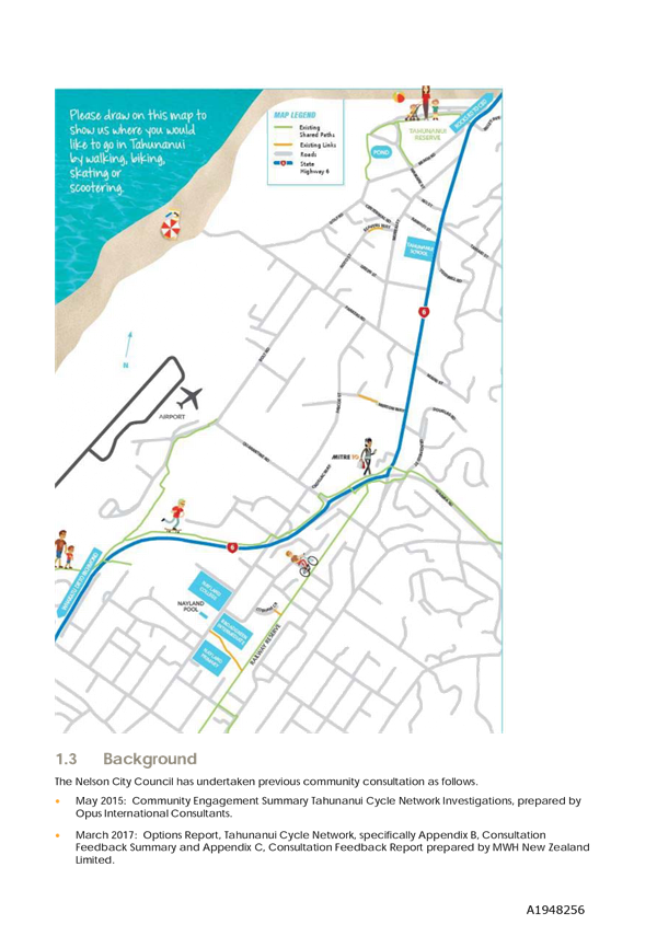
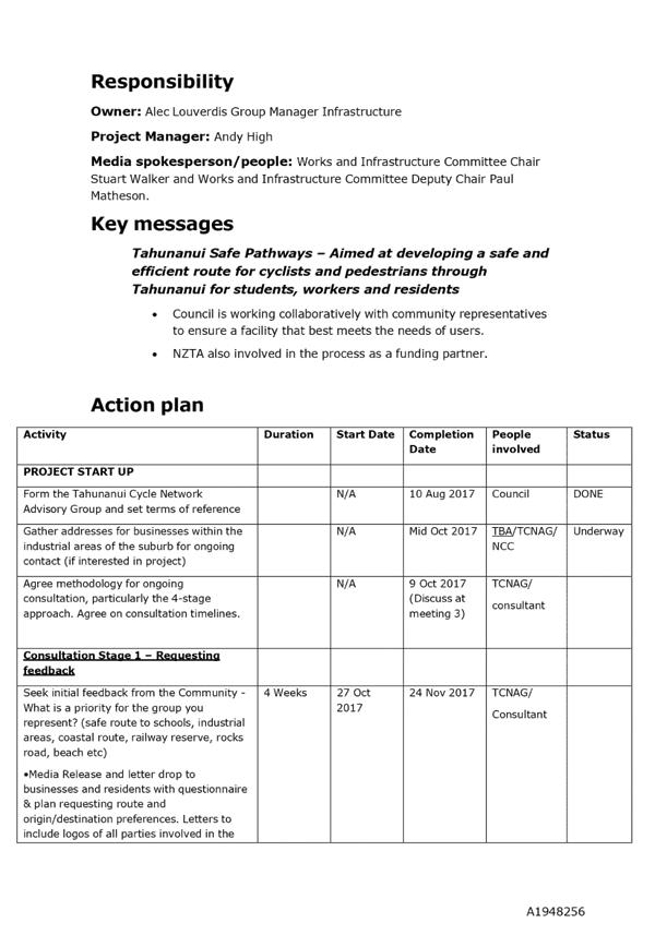
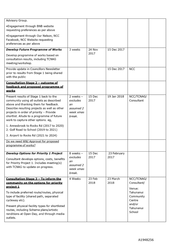
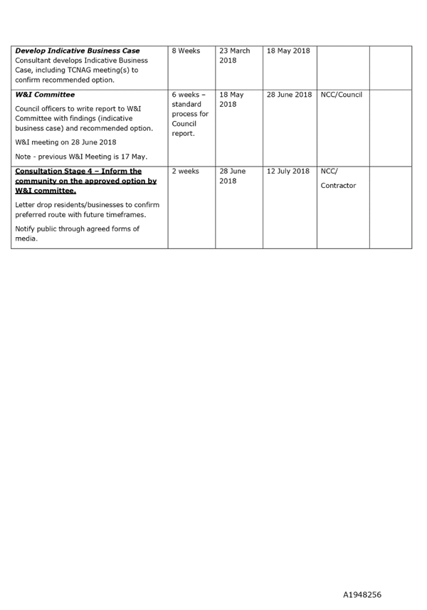
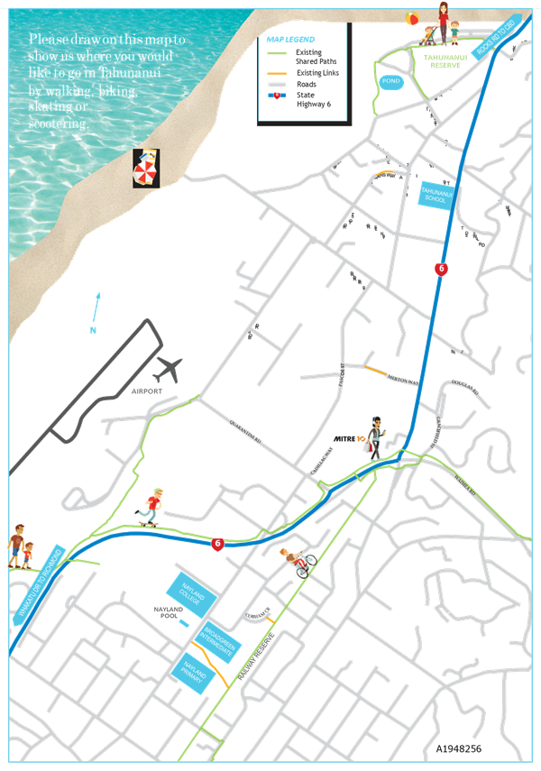
Attachment 1: Tahunanui Cycle Network
Consultation Summary (A1948256) ⇩
Attachment 2: Tahunanui
Cycle Network package of works (A1979013) ⇩
|
Important considerations for decision making
|
|
1. Fit
with Purpose of Local Government
This project will link existing cycling
infrastructure and promote active transport participation rates.
|
|
2. Consistency
with Community Outcomes and Council Policy
The 2018-28 Asset Management Plan has set a target
of 25% of all journeys to be undertaken by walking or cycling by 2021-27. The
2015-2021 RLTP has set objectives to ensure the community has a range of
travel choices and supports national strategies for energy efficiency.
The recommendation will contribute to these goals by
appealing to a wide range of cyclists thereby promoting greater uptake of
active travel modes, supporting Nelson’ Active Travel Hierarchy and the
“Out and About” policy.
This project contributes to the following community
outcome - “Our infrastructure is efficient, cost effective and meets
current and future needs”; “Our unique natural environment is
healthy and protected”; “Our urban and rural environments are
people-friendly, well planned and sustainably managed” and “Our
Council provides leadership and a regional perspective”.
|
|
3. Risk
The risk to implementing the preferred options, due
to loss of parking, is high. However, due to the inclusive and collaborative
approach taken through the Group, it should be possible to win over negative
views in favour of community benefits, particularly the ability for school
children to get to school using active modes.
|
|
4. Financial
impact
The
project is NZTA subsidised and currently falls outside the window of when the
UCF needs to be spent. The RTC and Council have made a submission to the GPS
requesting that the UCF continue and officers are awaiting feedback from
Central Government. There is a risk that if the UCF is discontinued, then
Council’s share through the LTP will be 50% as opposed to 33%. However,
NCC contribution may reduce depending on the outcome of the Annesbrook Drive
portion potentially being fully funding by NZTA.
|
|
5. Degree
of significance and level of engagement
This matter is of medium significance. The work is
contained within road reserve and existing private accesses to the road
corridor are to be retained. Due to the loss of parking, targeted
consultation will need to be undertaken if the Committee approves the
preferred option.
Community consultation has been carried out as
detailed in Section 5 of this report. Close liaison will be required with
residents and businesses whose existing parking is affected and NZTA for
parts of the route located on State Highway road reserve.
|
|
6. Inclusion
of Māori in the decision making process
Maori have not been consulted on this project.
|
|
7. Delegations
The Works and Infrastructure Committee areas of
responsibility includes:
Cycleways and Shared Pathways with an active
transport focus.
|
Item
9: Tahunanui Cycle Network - Preferred Option: Attachment 1


Item
9: Tahunanui Cycle Network - Preferred Option: Attachment 2

Item 10: Church Street
Upgrade
|

|
Works and Infrastructure Committee
28 June 2018
|
REPORT R9055
Church
Street Upgrade
1. Purpose
of Report
1.1 The
purpose of the report is:
(a) To
agree, in the absence of a current city centre strategy, that Church Street is
a focus area for improvement; and
(b) If
the agreed option is to proceed with an upgrade of Church Street then:
(i) Confirm
the preferred option for upgrade; and
(ii) Confirm
the budget available to undertake the works.
2. Summary
2.1 Church
Street was identified in the Heart of Nelson Strategy (2009) as an area for
façade improvements to help enhance and support the city centre
amenity. This was to include verandah provision and footpath /
carriageway enhancement to encourage outdoor seating and a laneway
precinct. It was intended to improve linkages to a proposed performing
art/conference centre. The performing art/conference centre has not eventuated
and there is currently no updated strategic document that identifies the work
in Church Street as a priority area for work.
2.2 The
upgrade proposal arose from a number of property owners/occupiers in Church
Street asking for work to be undertaken. Council has worked in
partnership with these property owners/occupiers to develop a design.
2.3 The
total estimated cost of the design is $1,330,000. The total project budget is
$779,000 (note: this includes $204,000 from the water renewal programme).
2.4 Given
that the opportunity for completion this financial year has passed, should the
Committee agree to the preferred option, work would not take place until
between May and October 2019 at the earliest.
2.5 Several
key issues have been identified since tendering the project, resulting in a
total budget shortfall of $551,000 to deliver the preferred option as supported
by the owners/occupiers.
2.6 A
workshop was held with Councillors on 15 February 2018 where the financial
shortfall was discussed and four options were presented. These options
being:
|
Option No.
|
Description
|
Estimated Cost
|
Additional Budget
|
|
1
|
Upgrade Church St, Convert Road to Shared Zone
|
$1,330,000
|
$551,000
|
|
2
|
Upgrade Church St, Convert Road to Shared Zone with
Removal of Vegetation etc
|
$1,096,000
|
$317,000
|
|
3
|
Upgrade Church St by Retaining Existing Surfaces & Add
Above Ground Elements
|
$575,000
|
$0
|
|
4
|
Do Nothing and Consider City Development Strategy
|
$0
N.B. $107k spent
to date
|
$0
|
2.7 Councillors
expressed a desire to understand the option preferred by the Church Street
business and property owners. The feedback from the businesses and
property owners confirms they prefer Option 1. Option 3 (retain the existing
surfaces and add above ground elements) and Option 4 (do nothing) were less
preferred options.
2.8 A
considerable amount of time, cost and goodwill has been put into Option 1 by
both officers and the Church St business and property owners.
Officer’s support progressing with Option 1 as this option best meets the
desired outcomes. Officers do note that if this project was starting
right now (with the development of the City Centre Strategy about to commence),
then they would have recommended that the City Centre Strategy is undertaken
first, allowing for Church Street to be considered and prioritised as
part of the bigger picture.
3. Recommendation
|
That the Works and Infrastructure
Committee
Receives the report Church
Street Upgrade (R9055) and its
attachments (A1990747, A1977465, A1977517, A1979152 and A1952746).
|
Recommendation to Council
|
That the Council:
Approves Option 1 as presented
in Report R9055 at a total project cost of $1,330,000 to fund the Church
Street upgrade; and
Approves
additional unbudgeted funding of $551,000 for Option 1; and
Approves
the re-phasing of the project schedule and budget with $400,000 allocated to
2018/19 and $823,000 allocated to 2019/20, noting $107,000 has been spent to
date.
OR
Confirms
the additional costs are significant and unbudgeted and that any upgrade of
Church Street should be included in the City Centre Strategy being completed
in the 2018/19 year and prioritised accordingly.
|
4. Background
4.1 On
23 June 2016 the Works and Infrastructure Committee received a proposal for the
improvement of the Church Street urban environment from Church Street property
and business owners. The Committee resolved:
“AND
THAT $75,000 be
allocated from provision in the 2016/17 CBD Enhancement budget to engage with
stakeholders and develop a design for the upgrade of Church Street in the
2016/17 financial year;
AND
THAT the developed design be brought back to the Works and
Infrastructure Committee for approval prior to construction;
AND
THAT construction be prioritised in future Annual/Long Term
Plans.”
4.2 On
30 March 2017 the Committee received a further report to approve concept plans for
the Church Street improvements to allow detailed design to continue. The
concept design included:
· Flush roadway and
footpaths creating a pedestrian oriented environment.
· A one-way, formally
designated “Shared Zone” environment, with a self-enforcing low
design speed (approximately 20km/hr).
· Gateway treatments at
the street entrances.
· Increased pedestrian
path widths.
· Increased outdoor dining
space.
· Central area outside
café/restaurants as a focal point.
· Improved lighting for
aesthetics, usability and safety.
· Ability for property
owners and businesses to give identity to the street.
· Increased vegetation -
approximately 16 additional trees and green planting areas. (Note: 11 trees
have been included in the final detailed design phase.)
· Opportunity
to close the street on a temporary basis for festivals, markets and events
which was supported by the Church Street business and property owners.
4.3 The
Committee resolved as below:
“Approves
the concept design as detailed in Attachment 2 (A1719554) of report R7018 for
the improvement of Church Street that will allow detailed design and
construction to proceed; and
Directs
officers to engage in further discussions with business and property owners to
establish if a financial contribution can be achieved to enable catenary
lighting on Church Street, noting the budget limitation for lighting for this
project.”
4.4 The
overhead ‘catenary’ lighting shown on the concept plans was not
included to keep the project within budget and the owners/occupiers agreed to
fund the lighting to the amount of approximately $35,000.
4.5 Verandahs
cover which were a driver for the work under the Heart of Nelson Strategy was
not included in the concept design.
4.6 The
opportunity arose to replace an existing asbestos cement watermain within the
proposed worksite and this was subsequently included within the design, funded
from the Water Renewal 2017/18 work programme at an estimated cost of
$204,000. Whilst the watermain did not need renewing, constructing directly
on top of the existing watermain would have significantly increased the
likelihood of failure and the need for ongoing repairs, and possibly a
replacement within 10 years of upgrade. Were it not for the upgrade
to Church Street the watermain is not expected to require renewal within the
next 10 years.
4.7 The
approved and available budget for the Church Street upgrade is as follows:
|
Item
|
Amount
|
|
Church Street Upgrade
|
$575,000
|
|
Watermain Upgrade
|
$204,000
|
|
Total Budget
|
$779,000
|
|
Spent to Date
|
$107,000
|
|
Available Budget
|
$672,000
|
5. Discussion
Strategy for the Area
5.1 An
upgrade of Church Street is included in the Heart of Nelson Strategy (2009),
along with a number of other suggested improvements for the city centre.
The Heart of Nelson Strategy saw the street as a connection between the
Rutherford Hotel and at that time a proposed performing arts/conference centre
with canopies to protect pedestrians from the weather. The Rutherford
Hotel subsequently constructed the conference centre within the hotel building
in 2014 and the performing arts centre did not progress.
5.2 No
rain/sun canopies are included within any option outlined in this report.
5.3 Council
has committed to including a focus on the city centre through the 2018/28 Long
Term Plan. The City Development Team will, when the vacancy is filled,
develop an updated strategy for focus areas within the city centre. This
strategy will include a prioritised programme of work centred on development
and improvement opportunities that are expected to maximise desired benefits
given budgetary allocation. The anticipated date for completing this updated
strategy is June 2019.
5.4 A
trial closure of Upper Trafalgar Street was carried out from December 2017
through to the end of March 2018. The purpose of the closure was to
create an inviting pedestrian-friendly space for Nelsonians and visitors to
enjoy and to test the feasibility of declaring Upper Trafalgar Street a
pedestrian mall every summer. Council provided seating and shade for the
community spaces and businesses extended their outdoor dining areas. This
closure was supported by retailers within Upper Trafalgar St and the public
more generally but has raised concern amongst other retailers about the need
for the City Centre Strategy so other areas are known and prioritised.
Costs
5.5 The
project was tendered in October 2017 and tenders received were greater than
budget by $313,000. The two main reasons for the increase in tender costs
were:
· The local
construction market being very buoyant, which is resulting in greater
construction costs. This issue has been costed at $240,000.
· During the
detailed design phase, additional requirements costed at $73,000 were allowed
for, including:
o Greater depth of road pavement
being replaced.
o Increased extent of reseal on
Hardy Street and Selwyn Place.
o Amendments requested from the
Blind Foundation.
o Perimeter Paving introduced
around the block paving area.
o Use of tree pit
‘cells’ to improve longevity of proposed trees (from 5 – 10
years to 50 years).
5.6 In
addition, as a result of the Queens Street upgrade in Tasman where hazardous
coal tar material was identified, officers assessed this risk as being high,
and subsequently tested the Church Street site and discovered coal tar.
The production of coal tar took place at the old Nelson Gas Works located in
Haven Road. This facility was producing gas from coal from 1873 until
1971. Coal tar is a waste product from the gas production process. It is
carcinogenic and is considered a hazardous material under the National
Environmental Standard for Assessing and Managing Contaminants in Soil to
Protect Human Health. Coal tar waste has been used widely in New Zealand
and overseas in the construction of roads. Its use was gradually phased
out through the 1970’s. The estimated cost to manage this issue is
$150,000.
5.7 These
issues, along with an increase in risk contingency and additional costs for
associated delay, result in a budget shortfall of $551,000 for the current
design, referred to as Option 1.
5.8 There
is no budget within the infrastructure area for this shortfall.
5.9 Four
options have been considered to address these issues. Further detail on
these options is described in Section 6 and Attachment 1 of this report.
|
Option No.
|
Description
|
Estimated Cost
|
Additional Budget
|
|
1
|
Upgrade Church St, Convert Road to Shared Zone
|
$1,330,000
|
$551,000
|
|
2
|
Upgrade Church St, Convert Road to Shared Zone with
Removal of Vegetation etc
|
$1,096,000
|
$317,000
|
|
3
|
Upgrade Church St by Retaining Existing Surfaces & Add
Above Ground Elements
|
$575,000
|
$0
|
|
4
|
Do Nothing and Consider City Development Strategy
|
$0
N.B. $107k spent
to date
|
$0
|
5.10 Option
2 issues and risks are similar to Option 1 but the overall cost is lower due to
the reduction in amenity features.
5.11 Option
3 is expected to be within budget as many below ground risk items are removed
and the significant roading elements are not included.
Consultation
5.12 A
workshop was held with Councillors on 15 February 2018 where the financial
shortfall was discussed and these four options were presented.
Councillors expressed a desire to understand the option preferred by the Church
Street business and property owners.
5.13 Officers
presented the options to the business and property owners on 22 February
2018. The Church Street Committee (made up of local business and property
owners) undertook wider consultation with those unable to attend the meeting
and confirmed a preference for Option 1 (continuing with the design as
originally proposed). They confirmed they would not provide any further
funding over the approximately $35,000 for the overhead catenary lighting (a
combination of financial contributions and works in kind). They accept
they will need to also meet the costs of renting footpath space outside their
premises for dining and any costs associated with temporary street closures.
5.14 Officers
met again with business and property owner representatives on 21 May 2018 to
discuss in more detail Option 3 (retain existing surfaces and add above ground
elements). This option had been further developed since the meeting on
the 22 February 2018. The business and property owners who attended this
meeting confirmed that as a group their preferred choice remained Option
1. Those who attended also stated that either Option 3 or Option 4 (do
nothing) were their second choices, although this varied between
business/property owners and did not represent the group as a whole.
Construction Schedule
5.15 Flexibility
was provided when the project was tendered, by allowing construction to take
place within a 6 month window. The local businesses confirmed that they
did not want construction taking place from November to April as this would
have an adverse effect on their businesses.
5.16 The
work cannot now be completed within the current construction window.
Therefore, any construction work would have to wait to next financial year
(i.e. May to October 2019) or future years depending on the option
approved.
Outcomes and Benefits
5.17 The
outcomes and expected benefits for this project are summarised in the table
below:
|
Outcomes
|
%
|
Expected Benefits - Investment Objectives
|
|
Increase street amenity
|
70%
|
· Increase in
pedestrian counts during the day and evening.
· Increase
retail spend.
· Increase
use of outdoor space.
· Positive
news stories about the street.
· Improved
night time light levels.
· Maintain
full occupancy rates of rentable/commercial spaces.
· Increase in
visitor length of stay.
· Enhanced
opportunity to activate additional spaces.
· Reduce
average traffic speeds (stakeholders request).
|
|
Improve traffic efficiency
and overall safety
|
30%
|
· Reduce
vehicle conflicts and confusion.
· Reduce
bottlenecks or unintended network efficiencies (i.e. rat runs).
· Improve
safety for cyclists, pedestrians, and vehicle movements.
|
5.18 If
the project was starting following completion of the City Centre Strategy, it
is unclear whether the outcomes above would remain the same.
6. Options
6.1 A
summary of the four options are summarised in this section. The
advantages, disadvantages, financial summaries, timeframes and outcomes
assessment for the four options are discussed in detail in Attachment 1.
|
Option and Description
|
Est Cost
|
|
Option 1 - Upgrade Church Street, Convert Road to
Shared Zone
Maintain the one way traffic flow from Hardy to Selwyn
Place, but extend it for the full length of Church Street. Double
extent of pedestrian space and convert road to shared space.
Use of urban design principles to enliven streetscape and
improve dining space and connections through Church Street
Key features include: the flush roadway and footpaths
creating a pedestrian oriented environment; gateway treatments at the street
entrances; improved lighting for aesthetics, usability and safety; ability
for property owners and businesses to give identity to the street; central
area outside café / restaurants as a focal point; increase in green
space and trees.
Businesses fund the catenary lighting.
Renew existing watermain.
Refer to Attachment 2 for artistic impression.
Timeline:
· Construction
Window - May 2019 to October 2019
|
CAPEX: $1.330M
OPEX Yr1: $56k
ADDITIONAL FUNDING REQUIRED
$551k
|
|
Option 2 - Upgrade Church Street, Convert Road to
Shared Zone with Removal of Vegetation etc
As per Option 1 except for the removal of some items
including, public seating, tree pits, vegetation, several rubbish recycling
bins, quality paving in the central area and public drinking fountain.
Businesses fund the catenary lighting.
Renew existing watermain.
Refer to Attachment 3 for artistic impression.
Timeline:
· Construction
Window - May 2019 to October 2019
|
CAPEX: $1,096k
OPEX Yr1: $40k
ADDITIONAL FUNDING REQUIRED
$317k
|
|
Option 3 - Upgrade Church Street by Retaining Existing
Surfaces & Add Above Ground Elements
The aim is to create improved
outdoor dining experiences, constructing an aesthetic vibrant pedestrian
friendly street scape – includes catenary lighting.
This involves retaining the
majority of the existing roadway pavements but working with the Church Street
business and property owners to provide an improved dining experience
(increased dining area and catenary lighting), utilising local artists to
enliven the street, e.g. artwork, entranceway features and placement of
planter boxes.
Council funds the catenary lighting.
Watermain is not renewed as majority of road is
unaffected.
Refer to Attachment 4 for artistic impression.
Timeline:
· Stakeholder Engagement,
Concept Design – 2018/19
· Design, Procurement –
2019/20
· Construction
phased over 2019/20 to 2020/21.
|
CAPEX: Est $575k
OPEX Yr1 $31.5k
ADDITIONAL FUNDING REQUIRED
Nil
|
|
Business Option 4 - do nothing different –
baseline
Leave street as is and consider in the city development
strategy
|
CAPEX: $0k
OPEX: write off of $107k spent to date
|
6.2 These
four options were evaluated under a multi-criteria analysis (MCA). Each
indicator was scored from 1 to 5. Where 5 is the ‘best’ (as
contributing most improvement) and 1 is the ‘worst’. Refer to
Attachment 1 for further detail on the decision criteria, indicators and MCA.
|
Indicator
|
Weight
|
Option 1
|
Option 2
|
Option 3
|
Option 4
|
|
Scale of benefit improvement - Street Amenity
Ref to Attachment 5
|
40%
|
5
|
3
|
3
|
1
|
|
Cost
|
30%
|
1
|
3
|
4
|
5
|
|
Scale of benefit improvement: traffic flow efficiency and
user safety
|
20%
|
5
|
5
|
4
|
1
|
|
Stakeholder support
|
10%
|
5
|
1
|
3
|
3
|
|
Total
|
100%
|
3.8
|
3.2
|
3.5
|
2.4
|
|
Rank
|
1
|
3
|
2
|
4
|
6.3 The
outcome from the MCA shows that Option 1 is the highest scoring, followed by
Option 3 and then Option 2.
6.4 When
taking into account the MCA, a review of the business case, and the views
expressed by the owners/occupiers, officers consider Option 1 is likely to
bring the most benefit. If the job is to proceed then it should be done
in a manner that adds to the vitality of the city centre rather than a solution
to fit within budget. It is acknowledged that Option 3 can be achieved
within the existing budget. Option 2 has been discounted by officers
because it does not achieve many of the amenity aims of the project and it is
the least preferred option of the business and property owners.
6.5 With
any option, other than Option 1, there will be disappointment from the Church
Street owners/occupiers. Officers have worked in partnership with them
for some period of time and there is a raised expectation that works will
occur.
6.6 A
considerable amount of time, cost and good will has been put into Option 1 by
both officers and the Church St business and property owners.
Officer’s support progressing with Option 1 as this option best meets the
desired outcomes. Officers do note that if this project was starting
right now (with the development of the City Centre Strategy about to commence),
then officers would have recommended that the City Centre Strategy is undertaken
first, allowing for Church Street to be considered and prioritised as
part of the bigger picture.
6.7 There
has been no engagement with the wider Nelson retail community to canvas their
views on where activation should occur and in what order. Progression of
work on Church Street may result in negative comments from other retailers
within Nelson.
7. Conclusion
7.1 The
Church Street Upgrade project progresses an idea that has been put forward by
business and property owners on the street.
7.2 Officers
have worked in partnership with the businesses since 2016 to develop a design
that best meets the desired benefits for the project.
7.3 Several
key issues have come to light resulting in a budget shortfall of $551,000 if
Option 1 (proposed and supported by the owners/occupiers) is progressed.
7.4 Each
option has been assessed against decision criteria and officers recommend
Option 1 is developed through to construction. If the unbudgeted
additional costs of the work are considered to be significant then officers
recommend nothing further occur at this time until the completion of the City
Centre Strategy work which will include a prioritisation of work areas.
7.5 Should
the Committee recommend any option to Council, construction is planned to be
undertaken from May to October 2019 with the exception of Option 3 which would
be phased over 2 years (19/20-20/21).
Clare
Barton
Group
Manager Environmental Management
Attachments
Attachment 1: A1990747 - Description of
Options and Multi Criteria Analysis ⇩
Attachment 2: A1977465
- Option 1 - Artist Impression ⇩
Attachment 3: A1977517
- Option 2 - Artist Impression ⇩
Attachment 4: A1979152
- Option 3 - Artist Impression ⇩
Attachment 5: A1952746
- Assessment of Options Contribution to Street Amenity ⇩
|
Important
considerations for decision making
|
|
1. Fit with Purpose of Local Government
This project is expected to assist in increasing the
vitality, walkability and permeability of the central city bringing economic
and wellbeing benefit for the community.
|
|
2. Consistency with Community Outcomes
and Council Policy
The proposal contributes to the following community
outcome: ‘Our urban and rural environments are people-friendly, well
planned and sustainably managed’, and ‘Our communities are
healthy, safe, inclusive and resilient’
The proposal is also consistent with Nelson 2060,
Goal Seven states “Our economy thrives and contributes to a vibrant
and sustainable Nelson”.
|
|
3. Risk
The key risk is the removal of hazardous material
(Coal Tar). If works involve excavation below ground, then the risk of
encountering hazardous material is high. The consequence of this is
increased cost for disposal of waste to landfill. Options proposed in
this report allow for these costs, therefore reducing the consequence of this
risk to low.
An additional risk is the focus on Church St, in the
absence of a wider strategy, which may raise negative commentary from other
Nelson retailers and property owners within the city centre.
|
|
4. Financial impact
Should the Committee approve to proceed with the
Option 1, additional funding of $551,000 is required. Ongoing roading
maintenance costs will be funded through operational budgets.
|
|
5. Degree
of significance and level of engagement
This matter is considered of low significance.
Extensive consultation has been undertaken with the Church Street business
and property owners but no other retailers or business owners have been
consulted.
|
|
6. Inclusion of Māori in the
decision making process
Maori have not been consulted on this report.
|
|
7. Delegations
The Works and Infrastructure Committee has the
responsibility for considering the “roading network,
including associated structures, bridges and retaining walls, walkways,
footpaths and road reserve, landscaping and ancillary services and
facilities, street lighting and traffic management control”.
Council has delegated responsibility to approve
additional funding.
|
Item
10: Church Street Upgrade: Attachment 1
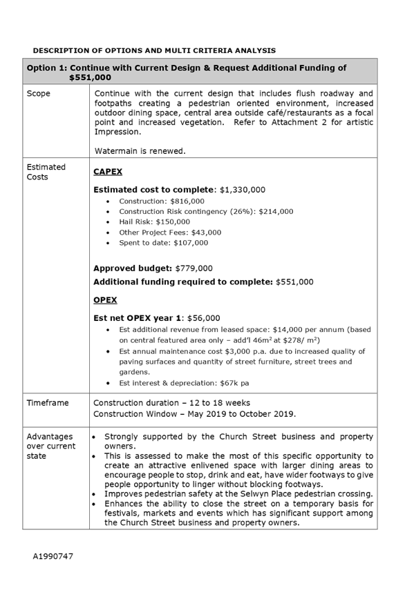
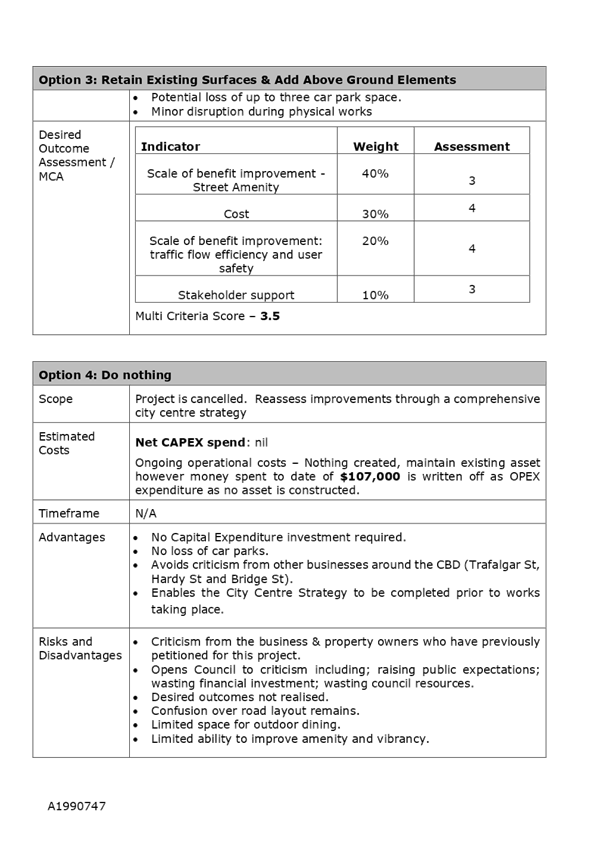
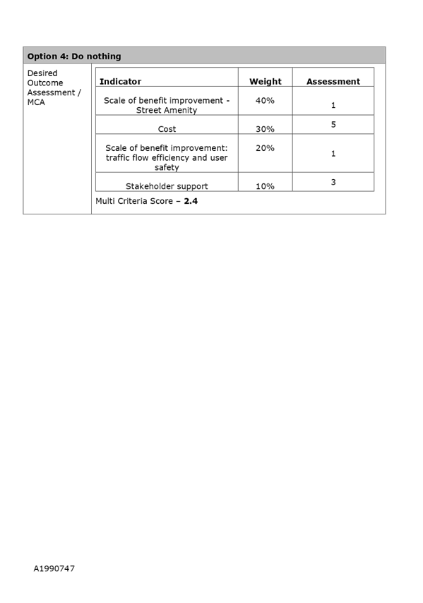
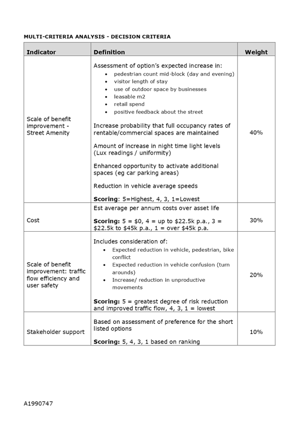
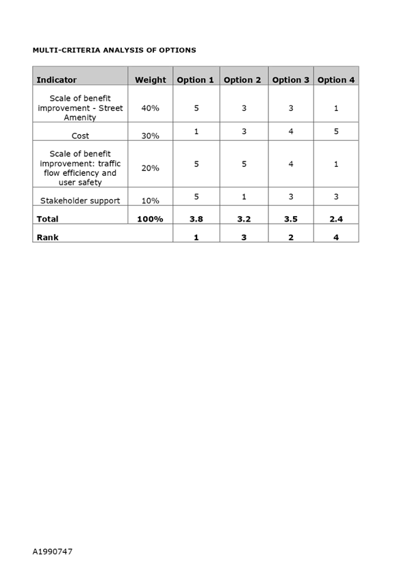
Item
10: Church Street Upgrade: Attachment 2
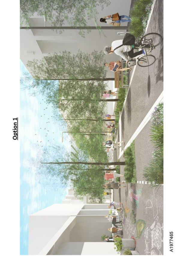
Item
10: Church Street Upgrade: Attachment 3
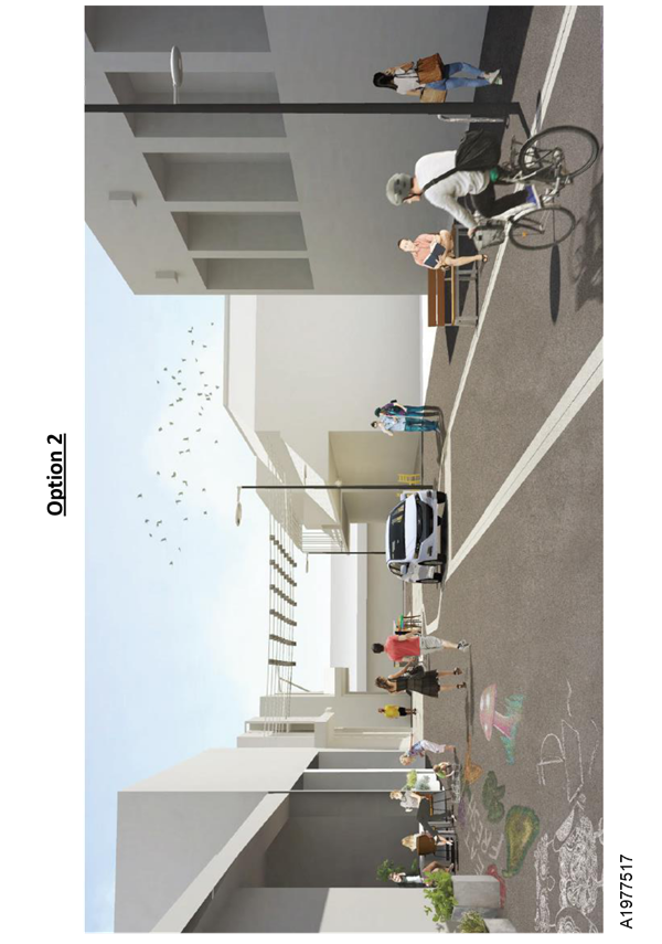
Item
10: Church Street Upgrade: Attachment 4
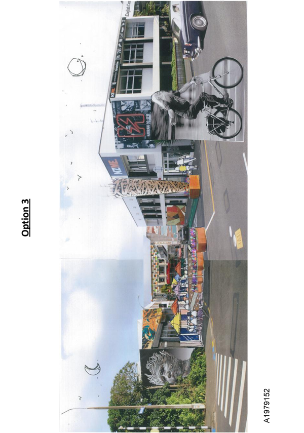
Item
10: Church Street Upgrade: Attachment 5
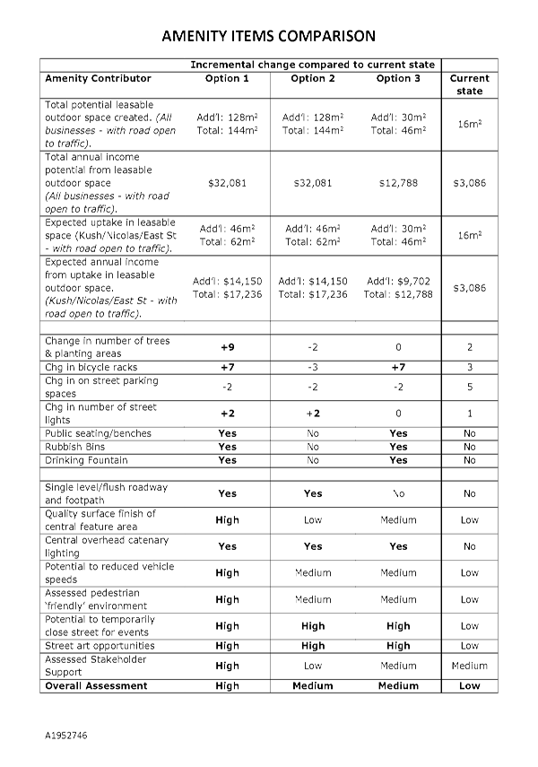
Item 11: Waimea Road
Severance - Pedestrian refuges
|

|
Works and Infrastructure Committee
28 June 2018
|
REPORT R9361
Waimea
Road Severance - Pedestrian refuges
1. Purpose
of Report
1.1 To
advise the committee on options to address severance across Waimea Road.
1.2 To
consider and approve a preferred location for a pedestrian refuge.
2. Summary
2.1 Council
resolved in March 2016 to investigate pedestrian severance along Waimea Road
between Tukuka Street and Boundary Road, recognising the poor level of service
to pedestrians wanting to cross Waimea Road.
2.2 The
draft Government Policy Statement (GPS) released in April 2018 places emphasis
on Safety and Access as priorities. Provision of safe crossing points on busy
arterial roads is consistent with this strategic direction.
2.3 A pedestrian refuge was installed as part of the stormwater
upgrade works at the intersection of Waimea Road and Boundary Road in June
2016.
2.4 Installing
another pedestrian refuge in the section of Waimea
Road between Tukuka and Boundary Road is challenging due to the high
number of private property access ways, high traffic volumes and safety
concerns for turning motorists.
2.5 This
report summarises the options to improve pedestrian amenity across Waimea Road.
3. Recommendation
|
That the Works and Infrastructure
Committee
Receives the report Waimea Road
Severance - Pedestrian refuges (R9361) and attachments (A1985032,
A1989357, A1985289, A1981206); and
Approves the installation of a pedestrian refuge in the preferred
location depicted on Option 3D (subject to approval by all private landowners
to a change in their Right of Way status) as detailed in Report R9361, to
allow progression to detailed design and construction; and
Approves
the installation of a pedestrian refuge in location Option 3C (as detailed in
Report R9361) should Option 3D be shown to be impractical following
consultation.
|
4. Background
4.1 In
March 2016 Council considered a report on “Waimea Road issues and
opportunities”. This report identified a number of projects for action
and investigation, including provision of a pedestrian/cycle refuge between
Tukuka Street and Boundary Road and officers were requested to initiate
consultation on these opportunities and report that feedback to a future Works
and Infrastructure meeting.
4.2 On
10 May 2016, the Works and Infrastructure committee approved the construction
of a pedestrian refuge immediately north of Boundary Road as part of the
stormwater upgrade, which has since been installed.
4.3 At
the March 2018 Works and Infrastructure meeting, the committee requested
officers to bring back a report to review and progress consideration of another
pedestrian refuge on Waimea Road between Tukuka and Boundary Road.
4.4 Officers
have undertaken an Indicative Business Case, assessed pedestrian movements and
investigated a number of locations. Officers have also had this work
independently assessed by Viastrada Limited (traffic engineers and planners
specialising in walking and cycling facilities).
5. Discussion
5.1 Waimea
Road traffic
5.1.1 Waimea
Road has a traffic volume of 24,000 vehicles/day, with an average of 2,200 vehicles/hour at peak times, making
it challenging for pedestrians/cyclists to cross Waimea Road and creating a
severance issue for the Bishopdale/Nelson South Community. The next safe
crossing facility other than the pedestrian refuge at Boundary Road is at the
intersection of Waimea Road and Tukuka Street. These two refuge crossings are
470 metres apart.
5.1.2 The
average speed along Waimea Road is 50km/h with three percent of the southbound
traffic travelling at speeds in excess of 70km/h.
5.1.3 There
were five reported crashes between Tukuka Street and Boundary Road in the five
year period 2013 to 2017 resulting from loss of control and nose to tail. No
crashes involving pedestrians were reported.
5.2 Pedestrian facilities guidelines
5.2.1 The Land Transport New Zealand Pedestrian Planning
Guide (Guide) shows various levels of service to pedestrians at different
crossing facilities (Attachment 1). The chart shows pedestrian delay based on
traffic volume and crossing facility type. It recommends that for the volumes
of traffic on Waimea Road that a pedestrian refuge with kerb build outs
provides a level of service that is on the cusp of acceptable levels (shown by
the red dot on the graph in attachment 1).
5.3 Waimea
Road pedestrian issues
5.3.1 A
survey of where pedestrians cross Waimea Road between Tukuka Street and Market
Road shows that 137 crossed Waimea Road between 7am and 6pm, comprising 28
students, 91 adults, and 18 elderly. Crossing demand was concentrated at Tukuka
Street (19%), Brunner Street walkway - north end of Russell Flats (15%) and
Boundary Road (17%), but was otherwise random. The location of crossing
facilities and bus stops on the length of Waimea Road from Bishopdale Hill to
Rutherford Street are shown on Attachment 2.
5.3.2 Nelson
Intermediate was consulted regarding their students crossing Waimea Road. Five
students regularly cross at Boundary Road, and four at Tukuka Street. They
reported that cars stop if the traffic is moving slowly or they wait for gaps
in traffic to cross. No concerns were raised.
5.3.3 Managers
of the Russell Flats were consulted on pedestrian demands from the Russell
Flats community. Concern was raised about attracting elderly pedestrians to a
crossing facility that might not deliver any safety benefits. Provision of a
refuge means elderly residents would still need to cross the live lanes
unaided.
5.4 Existing
and future pedestrian facilities
5.4.1 There
are two existing pedestrian refuge islands for pedestrians/cyclists to cross
Waimea Road – one at Tukuka Street and one at Boundary Road. These are
meeting some of the current demands with 36% of surveyed pedestrians using
these crossing points.
5.4.2 Pedestrian facilities also compete against parking
demand for kerbside space. Unless there is an existing no parking provision,
any pedestrian facility will result in loss of parking.
5.5 Bus stops
5.5.1 Bus
stops are a critical factor when considering the location of pedestrian
crossing points. In the section under consideration, there are 4 bus stops
– two southbound, the first being at 143 Waimea
Road, and the second adjacent to the Caltex Bishopdale, and two northbound at
178 Waimea Road and 136 Waimea Road.
5.5.2 The existing southbound bus stop adjacent to Caltex
Bishopdale was temporarily relocated to Russell Flats during the York Stream
stormwater upgrade works in 2016. This temporary location received very
positive public feedback and will become the permanent location.
5.6 Emergency services
5.6.1 A
pedestrian refuge could reduce vehicle access to the painted median, and this
could restrict passing opportunities for emergency vehicles. Waimea Road is
relatively wide and Emergency Services were
asked if they could accommodate a pedestrian refuge on the painted median in
the area of Russell Flats. Fire, Police and Ambulance services all responded
that they had no issues with a pedestrian refuge along this stretch of
road.
5.7 Resident turning movements and exact location of
refuge
5.7.1 A pedestrian refuge is considered to have a
“safety flaw” when it does not allow a right turning vehicle to
completely leave the traffic lane when turning right into a property and this
is a key consideration for Waimea Road due to its high traffic volume.
5.7.2 A pedestrian refuge will also impact on vehicles
turning right when exiting a property. Vehicles exiting a property are
inconvenienced in that they need to wait for a gap to cross both traffic lanes
at once because the refuge occupies the painted median where they could
previously wait until merging into traffic. These vehicles can turn left but
have to “go around the block” to return to their desired direction
of travel.
5.7.3 Officers have also gained knowledge from previously
installed pedestrian refuges around the City and a summary of where refuges
have been installed locally on arterial roads in recent years is appended as
Attachment 3. Complaints and concerns have been raised from these crossings
specifically in relation to vehicle turning movements. Mitigation measures have
been implemented to address some of these concerns.
5.7.4 Landowners potentially affected by a pedestrian refuge
along Waimea Road were written to in October 2017. Five responses were received
with comments generally in support of assisting pedestrians to cross Waimea
Road, but with concern about their individual vehicle access to their
properties.
5.7.5 Many Waimea Road driveways are very steep off the back
of the footpath or have steep crossings onto the road. These issues combined
with the traffic volume already make access challenging without further
restricting vehicular turning movements.
6. Financial
6.1 Pedestrian
refuges are funded through the NZTA Subsidised Transport Low Cost/Low Risk
(LC/LR) at 51% funding assistance.
6.2 The
implementation costs of the options considered as part of this report range
from between $115,000 (Option 3C) and $350,000 (Option 3D). Any option chosen
would need to be prioritised against other items in the LC/LR works programme.
The 2018-21 budget in the Regional land transport Plan (RLTP) for LC/LR is $10
million.
7. Options
7.1 Numerous
options were considered by officers and these were peer reviewed by an
independent consultant, Viastrada.
7.2 The
following options were considered but not pursued for the following reasons:
7.2.1 Overpass/Underpass
– The underpass option would not address Crime Prevention Through
Environmental Design (CPTED) principles. Both options have detour lengths that
would make such facilities unappealing to the target audience as the Waimea
crossing distance is simply too short, both would require utility service
relocations and property acquisition, both would have major impacts on traffic
during construction and both have an estimated cost of around $2.5M.
7.2.2 A
pedestrian crossing (zebra crossing) has not been considered as a viable option
because of the poor safety record associated with pedestrian crossings that are
not on raised platforms. A raised platform is not suited to an arterial such as
Waimea Road.
7.2.3 A
signalised pedestrian crossing (similar to Waimea Road outside Hampden Street
School) would have an impact on the traffic flow along Waimea Road. The pedestrian
volume is not considered high enough to justify the negative effects on traffic
flows or the estimated cost of $600,000.
7.3 The
Viastrada peer review considered the three options proposed by officers and one
further option (Option 3D) suggested by them - Option 3D had not been consulted
on. Refer to Attachment 4 for location plans.
7.4 Both
options 3A and 3B have safety flaws that relate to turning movements of traffic
into and out of driveways and have not been considered further.
7.5 There
are three options for the Committee to consider as detailed in the table below.
7.5.1 Option
1 – Do nothing;
7.5.2 Option
2 – Install pedestrian refuge at location 3C at an estimated cost of
$115,000.
7.5.3 Option
3 – Install pedestrian refuge at location 3D at an estimated cost of
$350,000. This is the preferred option of officers.
7.6 Options
3C and 3D require targeted consultation with directly affected residents
(property owners and tenants). Option 3D would require all private property
owners to agree to an easement change over their Right of Way (ROW). Officers
note that it would only take one land owner not to agree to this change to
their ROW to make this option unable to be implemented.
7.7 The
major difference and advantage of Option 3D over 3C is that Option 3D caters
for the known pedestrian desire line generated by the bus stop and the Brunner
Street Walkway that would result in the refuge getting more use than Option 3C
which is 50 metres further south. There is a risk pedestrians will not walk to
Option 3C, but merely cross the road at a location that suits them. Option 3D
is the safer crossing option but does however attract a much higher
implementation cost over Option 3C.
|
Option 1: Do nothing
|
|
Advantages
|
· No effect on
traffic flow or movement;
· Property
owners not affected;
· No loss of
parking.
|
|
Risks and Disadvantages
|
· Does not
address severance issue;
· No
improvement for pedestrians wanting to cross Waimea Road;
· No provision
for relocated bus stop pedestrian desire line;
· Ongoing
safety risk for pedestrians crossing Waimea Road;
· Potential to
suppress demand for walking as a mode of transport.
|
|
Option 2: Install Pedestrian
refuge at location 3C
|
|
Advantages
|
· Closer alignment
to recommendations in the National Pedestrian Planning Guide;
· Kerb
buildouts provide a shortened crossing distance, which particularly suits
elderly and children crossing the road;
· Provides a
protected pedestrian space on the painted median;
· Northbound
bus stop (outside 178 Waimea Road) does not need to be relocated.
· Addresses
anticipated desire line resulting from relocation of south bound bus stop,
from Caltex Bishopdale to Russell Flats.
· Least effect
on property access of all options. Two (of four) affected landowners in
support of refuge.
|
|
Risks and Disadvantages
|
· Drivers
coming out of driveway at 186 Waimea Road intending to turn right will have
to find a gap in traffic in both directions simultaneously, or turn left.
This affects three households;
· Currently
located at the least used pedestrian desire line;
· Loss of six
6 carparks;
· Buildouts
and refuge will limit carriageway width on Waimea Road which affect
over-dimension vehicles but design can include the removal of central island
to allow safe passage of over-dimension vehicles.
· Ongoing
safety risk for pedestrians crossing Waimea Road who chose not to use the
refuge.
· Refuge could
fail to deliver the safety benefits expected by less-able pedestrians
resulting in high safety risk for those pedestrians, because of the high
traffic volume and speed, and the time required for less-able pedestrians to
cross to/from the refuge.
· Residents
resist proposal in final targeted consultation prior to construction.
|
|
Option 3: Install Pedestrian
refuge at location 3D
|
|
Advantages
|
· Best fit to
the current pedestrian desire line so is expected to get the most pedestrian
use;
· Closer alignment to
recommendations in the national Pedestrian Planning Guide;
· Kerb
buildouts provide a shortened crossing distance, which particularly suits
elderly and children crossing the road.
· A refuge
provides a protected pedestrian space on the painted median which reduces the
risk for pedestrians waiting to cross the road.
|
|
Risks and Disadvantages
|
· High cost;
· Drivers
coming out of driveway at 178 Waimea Road, and Russell Flats driveway
intending to turn right will have to find a gap in traffic in both directions
simultaneously, or turn left. This affects 6 households and Russell Flats.
· Closer
proximity of realigned driveway may have an impact on quality of life for
residents in the Russell Flats.
· Risk of
complications with altering driveway and affected easements over council
land.
· Loss of at
least 6 carparks.
· Northbound
bus stop and shelter outside 178 Waimea Road will need to be relocated.
· Buildouts
and refuge will limit carriageway width on Waimea Road which will affect
over-dimension vehicles but design can include the removal of central island
to allow safe passage of over-dimension vehicles.
· Ongoing
safety risk for pedestrians crossing Waimea Road who would not use the
refuge.
· Residents
could resist proposal in final targeted consultation prior to construction
– it would only take one owner not to agree to a change in the easement
across their ROW for this option not to be able to be implemented.
|
8. Conclusion
8.1 Following
a detailed business case and independent peer review of those options, a
preferred option (Option 3D) to improve pedestrian levels of service on Waimea
Road between Tukuka Street and Boundary Road has been identified at an
estimated cost of $350,000. This option (option 3D) to realign the Russell
Flats driveway to provide a location for the refuge on the pedestrian desire
line is the preferred option.
8.2 The
preferred refuge option results in some loss of parking, but will provide a
safer crossing point for pedestrians.
8.3 Whilst
option 3D is the preferred option, it will require agreement from all private
landowners to change the easement across their Right of Way. It would only take
one resident to not agree to this for option 3D not to be able to be
implemented. Should this scenario eventuate, officer’s note that Option
3C would be a viable workable alternative location.
Margaret
Parfitt
Manager
Roading and Utilities
Attachments
Attachment 1: A1985032: Pedestrian
planning guide - Level of service graph ⇩
Attachment 2: A1983957:
Waimea Road crossing facilities and bus stop locations ⇩
Attachment 3: A1985289:
Recently installed pedestrian refuge islands on Nelson arterial roads ⇩
Attachment 4: A1981206:
Waimea Road pedestrian refuge options ⇩
|
Important considerations for decision making
|
|
1. Fit
with Purpose of Local Government
The report recommendation considers current and
future needs of communities in contributing to safe use of the roading and
parking network in the City. A pedestrian refuge on Waimea Road is something
the Council is authorised to deliver as a Road Controlling Authority - no
other agency can deliver this.
|
|
2. Consistency
with Community Outcomes and Council Policy
Provision of a Pedestrian Refuge on Waimea Road
aligns with Councils “Out and About” Policy, Community Outcomes
and Transport AMP by providing for transport choice, active transport, and
suitable safe and connected footpaths.
|
|
3. Risk
A pedestrian refuge does not preclude any future
developments on Waimea Road. It could be designed to be removed.
|
|
4. Financial
impact
At $200,000, the preferred option is roughly double
what a standard pedestrian refuge would cost. However this option does
provide the best outcome and can be funded from the Subsidised Transport Low
Cost/Low Risk at 51% funding assistance.
|
|
5. Degree
of significance and level of engagement
This matter is of medium significance as it affects
the driveways of several properties. Consultation has been undertaken but
further consultation will be required with the Russell Street flats if Option
3D is approved.
|
|
6. Inclusion
of Māori in the decision making process
Consultation with Maori has not been undertaken.
|
|
7. Delegations
The Works and Infrastructure Committee areas of
responsibility includes
“Roading network, including associated
structures, bridges and retaining walls, walkways, footpaths and road
reserve, landscaping and ancillary services and facilities, street lighting
and traffic management control”
|
Item
11: Waimea Road Severance - Pedestrian refuges: Attachment 1
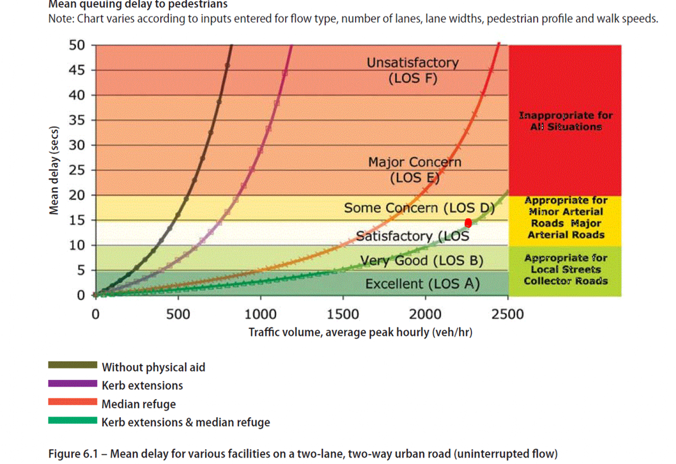
Item
11: Waimea Road Severance - Pedestrian refuges: Attachment 2
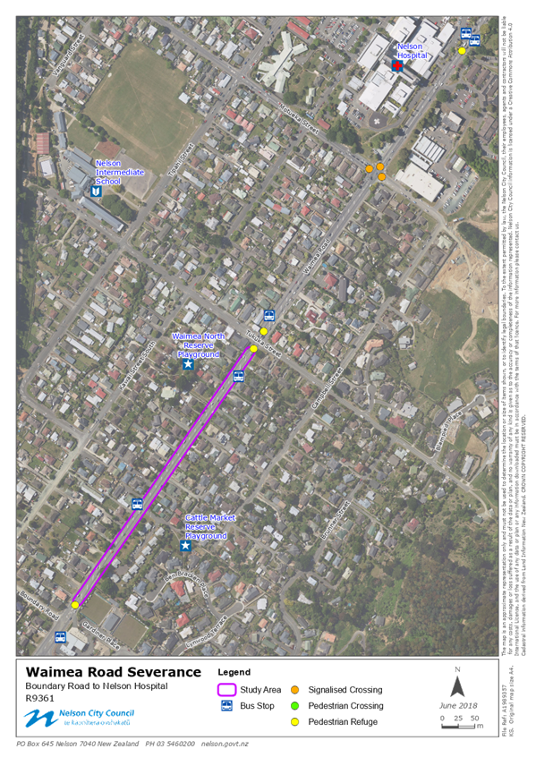
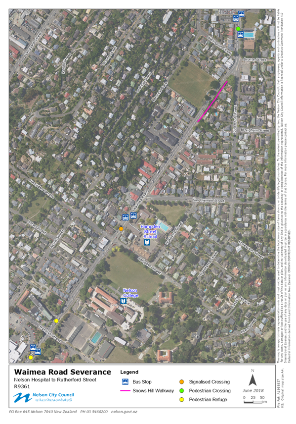
Item
11: Waimea Road Severance - Pedestrian refuges: Attachment 3
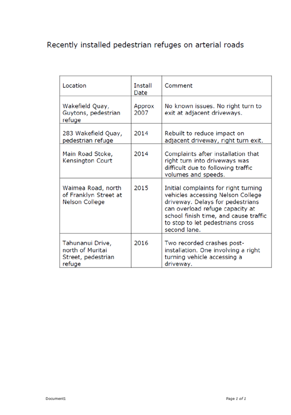
Item
11: Waimea Road Severance - Pedestrian refuges: Attachment 4